
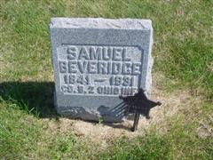
Samuel Beveridge
| Birth | : | 16 Nov 1841 Highland County, Ohio, USA |
| Death | : | 18 Mar 1931 Villisca, Montgomery County, Iowa, USA |
| Burial | : | St. John The Baptist Churchyard, Boldre, New Forest District, England |
| Coordinate | : | 50.7924070, -1.5422530 |
| Description | : | According to a Kinzer family researcher, Samuel was a Civil War veteran having served in the 81st Ohio Heavy Artillery for 21/2 years. He was a member of the Villisca, Iowa G.A.R. He married Christena Kinzer in Highland County, Ohio. Samuel Beveridge, father of Mrs. Carl Stanley of Coming, died at his in home in Villisca Monday morning, after an illness of a little more than a week. Mr. Beveridge was quite aged being eighty-nine years old, but until recently had enjoyed fairly good health. His son. Dr. T. F. Beveridge, of Muscatine. visited him last week and his... Read More |
frequently asked questions (FAQ):
-
Where is Samuel Beveridge's memorial?
Samuel Beveridge's memorial is located at: St. John The Baptist Churchyard, Boldre, New Forest District, England.
-
When did Samuel Beveridge death?
Samuel Beveridge death on 18 Mar 1931 in Villisca, Montgomery County, Iowa, USA
-
Where are the coordinates of the Samuel Beveridge's memorial?
Latitude: 50.7924070
Longitude: -1.5422530
Family Members:
Parent
Spouse

Siblings
Children

Flowers:


Nearby Cemetories:
1. St. John The Baptist Churchyard
Boldre, New Forest District, England
Coordinate: 50.7924070, -1.5422530
2. St Nicholas Churchyard
Brockenhurst, New Forest District, England
Coordinate: 50.8146060, -1.5681240
3. St Mary Churchyard
South Baddesley, New Forest District, England
Coordinate: 50.7691430, -1.5026160
4. St. Thomas the Apostle Churchyard
Lymington, New Forest District, England
Coordinate: 50.7576410, -1.5451200
5. Lymington Cemetery
Lymington, New Forest District, England
Coordinate: 50.7576200, -1.5576200
6. St. Mark's Churchyard
Pennington, New Forest District, England
Coordinate: 50.7545700, -1.5631100
7. St Luke Churchyard
Sway, New Forest District, England
Coordinate: 50.7839000, -1.6058800
8. Sway Cemetery
Sway, New Forest District, England
Coordinate: 50.7930690, -1.6131930
9. East Boldre Old Chapelyard
East Boldre, New Forest District, England
Coordinate: 50.8100600, -1.4756000
10. East Boldre Baptist Chapelyard
East Boldre, New Forest District, England
Coordinate: 50.8044770, -1.4707650
11. St Paul Churchyard
East Boldre, New Forest District, England
Coordinate: 50.8011710, -1.4693300
12. Beaulieu Cemetery
Beaulieu, New Forest District, England
Coordinate: 50.8046600, -1.4594000
13. All Saints Churchyard
Hordle, New Forest District, England
Coordinate: 50.7549400, -1.6136200
14. Blessed Virgin and Holy Child Churchyard
Beaulieu, New Forest District, England
Coordinate: 50.8216320, -1.4501550
15. Ashley Baptist Cemetery
New Milton, New Forest District, England
Coordinate: 50.7529200, -1.6336400
16. All Saints Churchyard
Milford-on-Sea, New Forest District, England
Coordinate: 50.7278170, -1.5897770
17. Lyndhurst Cemetery
Lyndhurst, New Forest District, England
Coordinate: 50.8723000, -1.5644600
18. Milford Road Cemetery
New Milton, New Forest District, England
Coordinate: 50.7472700, -1.6502700
19. St Michael and All Angels Churchyard
Lyndhurst, New Forest District, England
Coordinate: 50.8722520, -1.5778710
20. Christ Church Churchyard
Emery Down, New Forest District, England
Coordinate: 50.8742900, -1.5935600
21. New Milton Cemetery
New Milton, New Forest District, England
Coordinate: 50.7507690, -1.6650340
22. St Mary Magdalene Churchyard
New Milton, New Forest District, England
Coordinate: 50.7481200, -1.6645700
23. St James Churchyard
Yarmouth, Isle of Wight Unitary Authority, England
Coordinate: 50.7055370, -1.4991890
24. St Katherine Churchyard
Exbury and Lepe, New Forest District, England
Coordinate: 50.8003950, -1.3957510