
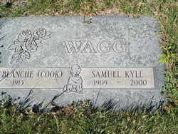
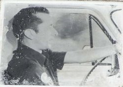
Samuel Kyle Wagg
| Birth | : | 28 Aug 1909 Mouth of Wilson, Grayson County, Virginia, USA |
| Death | : | 6 Oct 2000 Pateros, Okanogan County, Washington, USA |
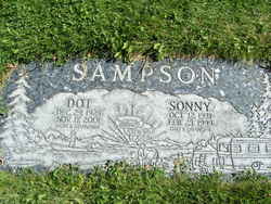
| Burial | : | Pateros Cemetery, Pateros, Okanogan County, USA |
| Coordinate | : | 48.0516600, -119.9097300 |
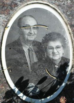
| Description | : | Samuel "Kyle" Wagg, 91, died suddenly at home on Friday, Oct. 6, 2000. Kyle was born Aug. 28, 1909, in Mouth of Wilson, VA. He moved to Pateros in 1929. In January of 1931, he married Blanche Cook of Pateros. They lived at McFarland Creek where he worked at Bennett's Sawmill for about six years. He then worked as a truck driver until he bought his own orchard on the Methow. After the big flood in 1948, he went to work for the Washington State Highway Department from which he retired in 1972. He lived in Brewster for the past 43... Read More |
frequently asked questions (FAQ):
-
Where is Samuel Kyle Wagg's memorial?
Samuel Kyle Wagg's memorial is located at: Pateros Cemetery, Pateros, Okanogan County, USA.
-
When did Samuel Kyle Wagg death?
Samuel Kyle Wagg death on 6 Oct 2000 in Pateros, Okanogan County, Washington, USA
-
Where are the coordinates of the Samuel Kyle Wagg's memorial?
Latitude: 48.0516600
Longitude: -119.9097300
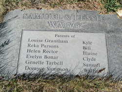
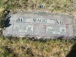
Family Members:
Parent

Spouse
Siblings
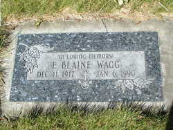
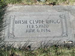
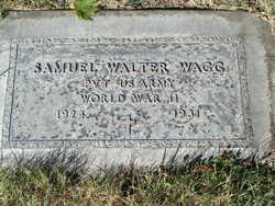
Children
Flowers:


Nearby Cemetories:
1. Pateros Cemetery
Pateros, Okanogan County, USA
Coordinate: 48.0516600, -119.9097300
2. Dick Family Cemetery
Okanogan County, USA
Coordinate: 48.0502700, -119.9241700
3. Miller Family Cemetery
Okanogan County, USA
Coordinate: 48.0530300, -119.9288000
4. Packwood Memorial Cemetery
Dyer, Douglas County, USA
Coordinate: 48.0118305, -119.8178880
5. Methow Cemetery
Methow, Okanogan County, USA
Coordinate: 48.1102982, -120.0124969
6. Locust Grove Cemetery
Brewster, Okanogan County, USA
Coordinate: 48.1114006, -119.7746964
7. Paradise Hill Cemetery
Brewster, Okanogan County, USA
Coordinate: 48.1848980, -119.8411900
8. Elizabeth Osborn Mikel Gravesite
Brewster, Okanogan County, USA
Coordinate: 48.1498900, -119.7514700
9. Bridgeport Cemetery
Bridgeport, Douglas County, USA
Coordinate: 48.0050000, -119.6738800
10. Fort Okanogan Memorial Cemetery
Okanogan, Okanogan County, USA
Coordinate: 48.1594009, -119.6632996
11. Chelan Fraternal Cemetery
Chelan, Chelan County, USA
Coordinate: 47.8502998, -120.0081024
12. Mount Olivet Cemetery
Chelan, Chelan County, USA
Coordinate: 47.8451000, -119.9946000
13. Saint Andrews Episcopal Church
Chelan, Chelan County, USA
Coordinate: 47.8397460, -120.0183780
14. Riverview Cemetery
Chelan, Chelan County, USA
Coordinate: 47.8335991, -119.9944000
15. Manson Indian Cemetery
Manson, Chelan County, USA
Coordinate: 47.8800000, -120.1300000
16. Chiliwist Cemetery
Okanogan County, USA
Coordinate: 48.2630997, -119.7363968
17. Buckingham Cemetery
Douglas County, USA
Coordinate: 47.8669014, -119.6286011
18. Malott Community Cemetery
Malott, Okanogan County, USA
Coordinate: 48.2925000, -119.7047300
19. Beaver Creek Cemetery
Twisp, Okanogan County, USA
Coordinate: 48.3272000, -120.0564000
20. Mansfield Cemetery
Mansfield, Douglas County, USA
Coordinate: 47.8088880, -119.6508330
21. Ballard Family Cemetery
Stayman, Chelan County, USA
Coordinate: 47.7811100, -120.1133300
22. Fletcher Cemetery
Douglas County, USA
Coordinate: 47.7430992, -119.9403000
23. Cameron Lake Pioneer Memorial Cemetery
Malott, Okanogan County, USA
Coordinate: 48.2708330, -119.5700000
24. Jean Cemetery
Mansfield, Douglas County, USA
Coordinate: 47.8292999, -119.4916000