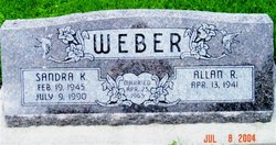
Sandra Kay Oliver Weber
| Birth | : | 19 Feb 1945 Logan, Harrison County, Iowa, USA |
| Death | : | 9 Jul 1990 Riverside County, California, USA |
| Burial | : | Saint John the Baptist Churchyard, North Cheriton, South Somerset District, England |
| Coordinate | : | 51.0309000, -2.4474000 |
| Description | : | California, U.S., Death Index, 1940-1997 Name: Sandra Kay Weber [Sandra Kay Oliver] Social Security #: 508548596 Gender: Female Birth Date: 19 Feb 1945 Birth Place: Iowa Death Date: 9 Jul 1990 Death Place: Riverside Mother's Maiden Name: Osborne Father's Surname: Oliver MARRIED April 25, 1965 to Allan Ray Weber, son of Ray & Ella Mae (Glawinski) Weber DEATH NOTICE: THE DUNLAP (IOWA) REPORTER DATED THURSDAY, JULY 12, 1990 Word was received here of the death of Mrs. Allan (Sandra) Weber of California. Funeral services have been scheduled for Monday morning, July 16,... Read More |
frequently asked questions (FAQ):
-
Where is Sandra Kay Oliver Weber's memorial?
Sandra Kay Oliver Weber's memorial is located at: Saint John the Baptist Churchyard, North Cheriton, South Somerset District, England.
-
When did Sandra Kay Oliver Weber death?
Sandra Kay Oliver Weber death on 9 Jul 1990 in Riverside County, California, USA
-
Where are the coordinates of the Sandra Kay Oliver Weber's memorial?
Latitude: 51.0309000
Longitude: -2.4474000
Family Members:
Parent
Spouse
Siblings
Flowers:
Nearby Cemetories:
1. Saint John the Baptist Churchyard
North Cheriton, South Somerset District, England
Coordinate: 51.0309000, -2.4474000
2. North Cheriton Cemetery
North Cheriton, South Somerset District, England
Coordinate: 51.0284840, -2.4389150
3. Saint Nicholas Churchyard
Holton, South Somerset District, England
Coordinate: 51.0401280, -2.4502641
4. St. Peter & St. Paul Churchyard
Maperton, South Somerset District, England
Coordinate: 51.0335993, -2.4686628
5. Saint John's Churchyard
Horsington, South Somerset District, England
Coordinate: 51.0126300, -2.4238400
6. St. Michael's Churchyard
Blackford, South Somerset District, England
Coordinate: 51.0336960, -2.4892290
7. Saint Peter & Saint Paul Churchyard
Charlton Horethorne, South Somerset District, England
Coordinate: 51.0060200, -2.4790100
8. St. Nicholas' Churchyard
Bratton Seymour, South Somerset District, England
Coordinate: 51.0679406, -2.4625400
9. Blessed Virgin Mary Churchyard
Compton Pauncefoot, South Somerset District, England
Coordinate: 51.0336770, -2.5089430
10. Saint Stephen Churchyard
Charlton Musgrove, South Somerset District, England
Coordinate: 51.0678630, -2.4008550
11. St Michael Churchyard
North Cadbury, South Somerset District, England
Coordinate: 51.0416670, -2.5213610
12. Corton Denham Cemetery
Corton Denham, South Somerset District, England
Coordinate: 51.0015810, -2.5202380
13. Saint Andrew Churchyard
Corton Denham, South Somerset District, England
Coordinate: 51.0015790, -2.5203100
14. All Saints Churchyard
Poyntington, West Dorset District, England
Coordinate: 50.9782070, -2.4997530
15. Civic Cemetery
Buckhorn Weston, North Dorset District, England
Coordinate: 51.0212440, -2.3484600
16. St Leonard Churchyard and Extension
Pitcombe, South Somerset District, England
Coordinate: 51.0925600, -2.4684600
17. St John The Baptist Churchyard
Buckhorn Weston, North Dorset District, England
Coordinate: 51.0212870, -2.3481780
18. St Lawrence Churchyard
Cucklington, South Somerset District, England
Coordinate: 51.0487190, -2.3507950
19. St Nicholas Churchyard
Henstridge, South Somerset District, England
Coordinate: 50.9762610, -2.3957980
20. Milborne Port Cemetery
Milborne Port, South Somerset District, England
Coordinate: 50.9662940, -2.4605880
21. Saint John's Churchyard
Charlton Musgrove, South Somerset District, England
Coordinate: 51.0840723, -2.3869787
22. Milborne Port Churchyard
Milborne Port, South Somerset District, England
Coordinate: 50.9653900, -2.4621550
23. St Peter Churchyard
Redlynch, South Somerset District, England
Coordinate: 51.0983279, -2.4299457
24. Castle Cary Cemetery
Castle Cary, South Somerset District, England
Coordinate: 51.0803800, -2.5223600


