
| Memorials | : | 0 |
| Location | : | Bratton Seymour, South Somerset District, England |
| Coordinate | : | 51.0679406, -2.4625400 |
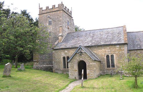
| Description | : | From the Church of Bratton Seymour, situated on the slope of Bratton Hill,there are outstanding views east towards Penselwood and St Alfred’s Tower. it is in the centre of a small scattered village, just to the north of the Wincanton-Castle Cary road near Jack White’s Gibbet, and dates back to Norman times. The name Bratton means farmstead by a brook with the suffix St Maur indicating manorial ownership by the family of that name. A Norman Font and the Norman south doorway are unique features of this simple two cell church of nave, chancel, and tower. The low perpendicular tower was... Read More |
frequently asked questions (FAQ):
-
Where is St. Nicholas' Churchyard?
St. Nicholas' Churchyard is located at Church Walk, Bratton Seymour, Wincanton, Somerset Bratton Seymour, South Somerset District ,Somerset , BA9 8BYEngland.
-
St. Nicholas' Churchyard cemetery's updated grave count on graveviews.com?
0 memorials
-
Where are the coordinates of the St. Nicholas' Churchyard?
Latitude: 51.0679406
Longitude: -2.4625400
Nearby Cemetories:
1. St Leonard Churchyard and Extension
Pitcombe, South Somerset District, England
Coordinate: 51.0925600, -2.4684600
2. Saint Nicholas Churchyard
Holton, South Somerset District, England
Coordinate: 51.0401280, -2.4502641
3. St. Peter & St. Paul Churchyard
Maperton, South Somerset District, England
Coordinate: 51.0335993, -2.4686628
4. St Peter Churchyard
Redlynch, South Somerset District, England
Coordinate: 51.0983279, -2.4299457
5. St. Michael's Churchyard
Blackford, South Somerset District, England
Coordinate: 51.0336960, -2.4892290
6. Saint John the Baptist Churchyard
North Cheriton, South Somerset District, England
Coordinate: 51.0309000, -2.4474000
7. All Saints
Castle Cary, South Somerset District, England
Coordinate: 51.0865760, -2.5165400
8. Saint Stephen Churchyard
Charlton Musgrove, South Somerset District, England
Coordinate: 51.0678630, -2.4008550
9. Castle Cary Cemetery
Castle Cary, South Somerset District, England
Coordinate: 51.0803800, -2.5223600
10. Church of the Holy Trinity
Bruton, South Somerset District, England
Coordinate: 51.1070450, -2.4843710
11. North Cheriton Cemetery
North Cheriton, South Somerset District, England
Coordinate: 51.0284840, -2.4389150
12. St Andrew Churchyard
Ansford, South Somerset District, England
Coordinate: 51.0943350, -2.5180470
13. Bruton Abbey
Bruton, South Somerset District, England
Coordinate: 51.1114890, -2.4530300
14. Blessed Virgin Mary Churchyard
Bruton, South Somerset District, England
Coordinate: 51.1115790, -2.4520520
15. Blessed Virgin Mary Churchyard
Compton Pauncefoot, South Somerset District, England
Coordinate: 51.0336770, -2.5089430
16. St Michael Churchyard
North Cadbury, South Somerset District, England
Coordinate: 51.0416670, -2.5213610
17. Saint John's Churchyard
Charlton Musgrove, South Somerset District, England
Coordinate: 51.0840723, -2.3869787
18. Bruton Cemetery
Bruton, South Somerset District, England
Coordinate: 51.1208280, -2.4464270
19. Stavordale Priory
Charlton Musgrove, South Somerset District, England
Coordinate: 51.0870410, -2.3778130
20. Saint John's Churchyard
Horsington, South Somerset District, England
Coordinate: 51.0126300, -2.4238400
21. St Nicolas' Churchyard
North Barrow, South Somerset District, England
Coordinate: 51.0623705, -2.5605033
22. Saint Peter & Saint Paul Churchyard
Charlton Horethorne, South Somerset District, England
Coordinate: 51.0060200, -2.4790100
23. Church of St John the Baptist
Brewham, South Somerset District, England
Coordinate: 51.1236330, -2.4017130
24. All Saint's Church
Alford, South Somerset District, England
Coordinate: 51.0916210, -2.5659300