

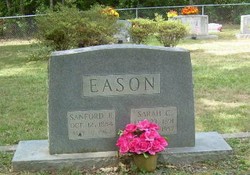
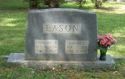
Sarah Catherine Tadlock Eason
| Birth | : | 23 Feb 1891 North Carolina, USA |
| Death | : | 7 Jul 1957 Lancaster County, South Carolina, USA |
| Burial | : | Sheppey Cemetery, Sheerness, Swale Borough, England |
| Coordinate | : | 51.4232780, 0.7718320 |
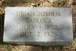
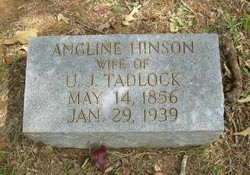
| Description | : | Sarah's South Carolina death certificate indicates she was married at the time of her passing. Her husband was Sanford Roscoe Eason and they wed on June 30, 1912 in Union Co., North Carolina. Sarah died from metastatic carcinoma of the femur along with complications from being diabetic. The certificate lists her parents as Joshua and Angeline Hinson Tadlock. Sarah was laid to rest in the Griffin Cemetery on July 8, 1957 |
frequently asked questions (FAQ):
-
Where is Sarah Catherine Tadlock Eason's memorial?
Sarah Catherine Tadlock Eason's memorial is located at: Sheppey Cemetery, Sheerness, Swale Borough, England.
-
When did Sarah Catherine Tadlock Eason death?
Sarah Catherine Tadlock Eason death on 7 Jul 1957 in Lancaster County, South Carolina, USA
-
Where are the coordinates of the Sarah Catherine Tadlock Eason's memorial?
Latitude: 51.4232780
Longitude: 0.7718320
Family Members:
Parent
Spouse
Siblings

Children
Flowers:


Nearby Cemetories:
1. Sheppey Cemetery
Sheerness, Swale Borough, England
Coordinate: 51.4232780, 0.7718320
2. Holy Trinity Churchyard
Queenborough, Swale Borough, England
Coordinate: 51.4174080, 0.7443560
3. Ss Mary and Sexburga New Churchyard
Minster on Sea, Swale Borough, England
Coordinate: 51.4235540, 0.8098720
4. Minster Abbey
Minster on Sea, Swale Borough, England
Coordinate: 51.4219320, 0.8119580
5. St James Churchyard
Grain, Medway Unitary Authority, England
Coordinate: 51.4585991, 0.7173300
6. All Saints Churchyard
Iwade, Swale Borough, England
Coordinate: 51.3787920, 0.7306550
7. All Saints Churchyard
Eastchurch, Swale Borough, England
Coordinate: 51.4068909, 0.8574320
8. Holy Trinity Churchyard
Milton Regis, Swale Borough, England
Coordinate: 51.3556700, 0.7401300
9. Garden of England Crematorium
Bobbing, Swale Borough, England
Coordinate: 51.3595330, 0.7179190
10. St Margaret of Antioch Churchyard
Lower Halstow, Swale Borough, England
Coordinate: 51.3752975, 0.6711660
11. St. Bartholomew's Churchyard
Bobbing, Swale Borough, England
Coordinate: 51.3537600, 0.7101420
12. St Giles Churchyard
Tonge, Swale Borough, England
Coordinate: 51.3424640, 0.7757790
13. Murston Cemetery
Sittingbourne, Swale Borough, England
Coordinate: 51.3424700, 0.7527100
14. Holy Trinity Church
Sittingbourne, Swale Borough, England
Coordinate: 51.3416000, 0.7316000
15. St Clement Churchyard
Leysdown, Swale Borough, England
Coordinate: 51.3970440, 0.9066620
16. St. Laurence's Churchyard
Bapchild, Swale Borough, England
Coordinate: 51.3330520, 0.7655020
17. St Mary the Virgin Churchyard
Upchurch, Swale Borough, England
Coordinate: 51.3764687, 0.6476030
18. St Mary the Virgin Churchyard
Newington, Swale Borough, England
Coordinate: 51.3567080, 0.6733120
19. St Mary Churchyard
Teynham, Swale Borough, England
Coordinate: 51.3377640, 0.8213570
20. Lower Stoke Methodist Chapelyard
Stoke, Medway Unitary Authority, England
Coordinate: 51.4537680, 0.6336680
21. Sittingbourne Cemetery
Sittingbourne, Swale Borough, England
Coordinate: 51.3345300, 0.7348000
22. All Saints Churchyard
Allhallows, Medway Unitary Authority, England
Coordinate: 51.4670950, 0.6417880
23. St Peter and St Paul Churchyard
Stoke, Medway Unitary Authority, England
Coordinate: 51.4452700, 0.6225300
24. Deerton Natural Burial Ground
Teynham, Swale Borough, England
Coordinate: 51.3344460, 0.8297850