

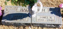
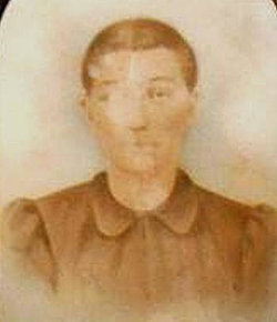
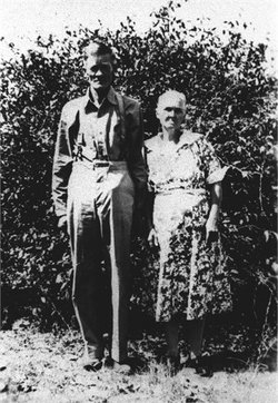
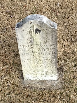
Sarah Elizabeth “Sadie” Jones Hackworth
| Birth | : | 22 May 1884 Gatewood, Ripley County, Missouri, USA |
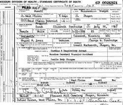
| Death | : | 30 Jul 1967 West Plains, Howell County, Missouri, USA |
| Burial | : | Fort Jackson National Cemetery, Columbia, Richland County, USA |
| Coordinate | : | 34.0900560, -80.8490750 |
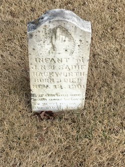
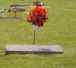
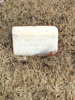
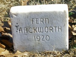
| Description | : | Daughter of Bryant H. Jones and Samantha A. (Miller) Jones. She was of the Freewill Baptist faith. Married James Newton Hackworth in 1900 at Gatewood, MO. Mother of Wade, Virgie Vesta, Josephine 'Josie' A., Arnett 'Arney' Leo, Ted O., Charles "Junior", Odie, David B., Grace Christine, Mardell, and an infant daughter. Married George Washington Sandridge 07/Dec/1954 in Oregon Co., MO. Burial, held 01/Aug/1967, is beside her first husband. |
frequently asked questions (FAQ):
-
Where is Sarah Elizabeth “Sadie” Jones Hackworth's memorial?
Sarah Elizabeth “Sadie” Jones Hackworth's memorial is located at: Fort Jackson National Cemetery, Columbia, Richland County, USA.
-
When did Sarah Elizabeth “Sadie” Jones Hackworth death?
Sarah Elizabeth “Sadie” Jones Hackworth death on 30 Jul 1967 in West Plains, Howell County, Missouri, USA
-
Where are the coordinates of the Sarah Elizabeth “Sadie” Jones Hackworth's memorial?
Latitude: 34.0900560
Longitude: -80.8490750
Family Members:
Parent
Spouse
Siblings

Children

Flowers:


Nearby Cemetories:
1. Fort Jackson National Cemetery
Columbia, Richland County, USA
Coordinate: 34.0900560, -80.8490750
2. Ford Family Graves
Columbia, Richland County, USA
Coordinate: 34.0919930, -80.8771630
3. Spears Creek Baptist Church Cemetery
Pontiac, Richland County, USA
Coordinate: 34.1042140, -80.8249520
4. Salem Methodist Church Cemetery
Richland County, USA
Coordinate: 34.0886002, -80.8116989
5. Spring Valley Presbyterian Memorial Gardens
Spring Valley, Richland County, USA
Coordinate: 34.1124482, -80.8804385
6. Enon Cemetery
Columbia, Richland County, USA
Coordinate: 34.0661011, -80.8788986
7. Royal Pines Independent Holiness Church Cemetery
Pontiac, Richland County, USA
Coordinate: 34.1211310, -80.8694600
8. Richland County Cemetery
Pontiac, Richland County, USA
Coordinate: 34.1223570, -80.8677770
9. Northeast Presbyterian Church Cemetery
Columbia, Richland County, USA
Coordinate: 34.0961690, -80.8919480
10. Saint Davids Episcopal Church Cemetery
Columbia, Richland County, USA
Coordinate: 34.0961790, -80.8929210
11. Saint John Neumann Catholic Church Cemetery
Columbia, Richland County, USA
Coordinate: 34.1033800, -80.8967150
12. Midway Methodist Church Cemetery
Columbia, Richland County, USA
Coordinate: 34.0756080, -80.8983890
13. Spring Valley Pentecostal Holiness Church Cemetery
Pontiac, Richland County, USA
Coordinate: 34.1100630, -80.8961530
14. Mount Pleasant Baptist Church Cemetery
Richland County, USA
Coordinate: 34.0514000, -80.8178000
15. Oak Grove Baptist Church
Elgin, Kershaw County, USA
Coordinate: 34.1368770, -80.8513150
16. Macedonia Cemetery
Richland County, USA
Coordinate: 34.0483017, -80.8846970
17. Corley Chapel Cemetery
Columbia, Richland County, USA
Coordinate: 34.0749454, -80.9081729
18. Alpine Baptist Church Cemetery
Columbia, Richland County, USA
Coordinate: 34.0650500, -80.9053840
19. Old Macedonia Cemetery
Columbia, Richland County, USA
Coordinate: 34.0664260, -80.9073220
20. Sandy Run Protestant Methodist Church Cemetery
Pontiac, Richland County, USA
Coordinate: 34.1475990, -80.8548260
21. Greenhaven Memorial Gardens
Richland County, USA
Coordinate: 34.1479590, -80.8245330
22. Jacobs Mission A.M.E. Church Cemetery
Richland County, USA
Coordinate: 34.1548030, -80.8506160
23. Enon Southern Methodist Church Cemetery
Columbia, Richland County, USA
Coordinate: 34.0569680, -80.9173300
24. Northeast Wesleyan Church Cemetery
Columbia, Richland County, USA
Coordinate: 34.1171350, -80.9236410