
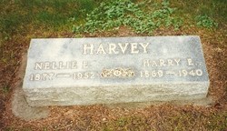
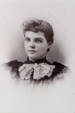
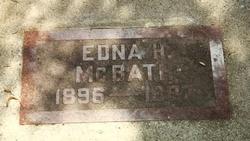
Sarah Ellen “Nellie” James Harvey
| Birth | : | 20 Nov 1876 Wyoming, Iowa County, Wisconsin, USA |
| Death | : | 24 Apr 1952 Watertown, Codington County, South Dakota, USA |
| Burial | : | Sunset View Cemetery, El Cerrito, Contra Costa County, USA |
| Coordinate | : | 37.9077721, -122.2871017 |
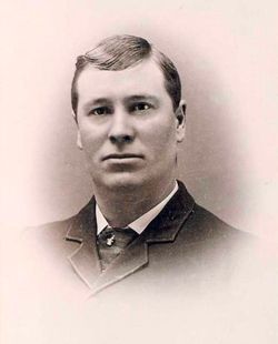
| Description | : | OBITUARY: Watertown Public Opinion, April 1952 Illness Fatal to Mrs. H.E. Harvey Was Pioneer Area Resident Mrs. H. E. Harvey, mother of Mrs. Earle McBath, 606 First street N.W., died this morning after a long illness. Mrs. Harvey, the former Nellie E. James, was born in Wyoming Prairie, Wis., Nov. 20, 1876. At the age of four she came to South Dakota with her parents and two brothers. Her parents had a homestead on the James river near Mellette. She married Harry E. Harvey in 1895. Mr. Harvey died 12 years ago. Her... Read More |
frequently asked questions (FAQ):
-
Where is Sarah Ellen “Nellie” James Harvey's memorial?
Sarah Ellen “Nellie” James Harvey's memorial is located at: Sunset View Cemetery, El Cerrito, Contra Costa County, USA.
-
When did Sarah Ellen “Nellie” James Harvey death?
Sarah Ellen “Nellie” James Harvey death on 24 Apr 1952 in Watertown, Codington County, South Dakota, USA
-
Where are the coordinates of the Sarah Ellen “Nellie” James Harvey's memorial?
Latitude: 37.9077721
Longitude: -122.2871017
Family Members:
Parent
Spouse
Siblings

Children
Flowers:


Nearby Cemetories:
1. Sunset View Cemetery
El Cerrito, Contra Costa County, USA
Coordinate: 37.9077721, -122.2871017
2. Golden Gate Mausoleum and Columbaria
El Cerrito, Contra Costa County, USA
Coordinate: 37.9073150, -122.2857220
3. Northbrae Community Church Columbarium
Berkeley, Alameda County, USA
Coordinate: 37.8905500, -122.2763200
4. Golden Gate Fields
Albany, Alameda County, USA
Coordinate: 37.8854000, -122.3117000
5. Salesian Cemetery
Richmond, Contra Costa County, USA
Coordinate: 37.9532650, -122.3401230
6. Saint Joseph Catholic Cemetery
San Pablo, Contra Costa County, USA
Coordinate: 37.9612700, -122.3336600
7. Saint Pauls Cemetery (Defunct)
San Pablo, Contra Costa County, USA
Coordinate: 37.9563332, -122.3430099
8. Rolling Hills Memorial Park
Richmond, Contra Costa County, USA
Coordinate: 37.9756012, -122.3146973
9. Saint Mary's Cemetery
Oakland, Alameda County, USA
Coordinate: 37.8349991, -122.2418976
10. Home of Eternity Cemetery
Oakland, Alameda County, USA
Coordinate: 37.8322970, -122.2448270
11. Chapel of the Chimes Columbarium and Mausoleum
Oakland, Alameda County, USA
Coordinate: 37.8318863, -122.2456894
12. Chapel of Memories Columbarium
Oakland, Alameda County, USA
Coordinate: 37.8310471, -122.2480927
13. Gan Shalom Cemetery
Contra Costa County, USA
Coordinate: 37.9528122, -122.1975098
14. Mountain View Cemetery
Oakland, Alameda County, USA
Coordinate: 37.8327600, -122.2395200
15. Saint Stephens Episcopal Church Memorial Garden
Orinda, Contra Costa County, USA
Coordinate: 37.8982650, -122.1729170
16. Cathedral of Christ the Light Mausoleum
Oakland, Alameda County, USA
Coordinate: 37.8105316, -122.2633896
17. Lafayette-Orinda Presbyterian Church Garden
Contra Costa County, USA
Coordinate: 37.8866040, -122.1606950
18. Yerba Buena Island Cemetery (Defunct)
San Francisco, San Francisco County, USA
Coordinate: 37.8127420, -122.3707880
19. Saint Paul Lutheran Church
Oakland, Alameda County, USA
Coordinate: 37.8020820, -122.2222780
20. Angel Island Cemetery (defunct)
Tiburon, Marin County, USA
Coordinate: 37.8621830, -122.4325920
21. Home of Peace Cemetery
Oakland, Alameda County, USA
Coordinate: 37.7790604, -122.2036285
22. First Street Cemetery (Defunct)
San Francisco, San Francisco County, USA
Coordinate: 37.7906170, -122.3991770
23. Muir-Strentzel Hanna Cemetery
Martinez, Contra Costa County, USA
Coordinate: 37.9784393, -122.1232681
24. Bush Street Cemetery (Defunct)
San Francisco, San Francisco County, USA
Coordinate: 37.7907950, -122.4011960