
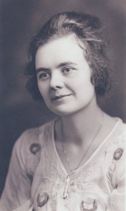
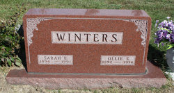
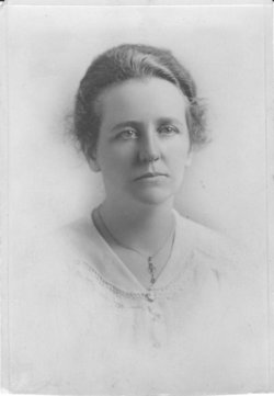
Sarah Etta Mudgett Winters
| Birth | : | 10 Feb 1894 Galesburg, Jasper County, Iowa, USA |
| Death | : | 19 Nov 1991 Knoxville, Marion County, Iowa, USA |
| Burial | : | St Chad's, Tamworth Borough, England |
| Coordinate | : | 52.6433000, -1.7418000 |
| Description | : | Sarah E. Winters Services for Sarah E. Winters, 97, of Knoxville, who passed away Nov. 19, 1991 at Knoxville Area Community Hospital, were held Nov. 21 at Evans-McClerry Funeral Home. Interment was in Hewitt Cemetery in Reasnor. Rev. Herbert Lewellen officiated at the services. Music was provided by organist Jim Kidder and vocalists John Winters and Teresa Lucas. Casketbearers were John Winters, Irv Pettyjohn, Ron Wilhite, Michael Winters and Tim Lucas. Mrs. Winters was born on Feb. 10, 1894 in Galesburg, the daughter of Woodbury and Harriett Luella Awtry Mudgett.... Read More |
frequently asked questions (FAQ):
-
Where is Sarah Etta Mudgett Winters's memorial?
Sarah Etta Mudgett Winters's memorial is located at: St Chad's, Tamworth Borough, England.
-
When did Sarah Etta Mudgett Winters death?
Sarah Etta Mudgett Winters death on 19 Nov 1991 in Knoxville, Marion County, Iowa, USA
-
Where are the coordinates of the Sarah Etta Mudgett Winters's memorial?
Latitude: 52.6433000
Longitude: -1.7418000
Family Members:
Parent
Spouse
Siblings
Children
Flowers:


Nearby Cemetories:
1. St Chad's
Tamworth Borough, England
Coordinate: 52.6433000, -1.7418000
2. Hopwas Cemetery
Tamworth, Tamworth Borough, England
Coordinate: 52.6417200, -1.7362600
3. St Bartholomew Churchyard
Hints, Lichfield District, England
Coordinate: 52.6237460, -1.7683840
4. St. Editha Churchyard
Tamworth, Tamworth Borough, England
Coordinate: 52.6344040, -1.6946000
5. Wigginton Road Cemetery
Tamworth, Tamworth Borough, England
Coordinate: 52.6479590, -1.6928170
6. St Mary the Virgin New Churchyard
Weeford, Lichfield District, England
Coordinate: 52.6330806, -1.7923083
7. St. Mary the Virgin Churchyard
Weeford, Lichfield District, England
Coordinate: 52.6322300, -1.7923200
8. St. Giles' Churchyard
Whittington, Lichfield District, England
Coordinate: 52.6723850, -1.7677160
9. St. Paul's Churchyard
Fazeley, Lichfield District, England
Coordinate: 52.6128860, -1.7002090
10. St Leonard Churchyard
Wigginton and Hopwas, Lichfield District, England
Coordinate: 52.6704490, -1.6927530
11. Glascote Cemetery
Glascote, Tamworth Borough, England
Coordinate: 52.6290130, -1.6774860
12. St Peter Churchyard
Drayton Bassett, Lichfield District, England
Coordinate: 52.5993180, -1.7165990
13. St Peter's Churchyard
Elford, Lichfield District, England
Coordinate: 52.6928330, -1.7274120
14. Wilnecote New Cemetery
Wilnecote, Tamworth Borough, England
Coordinate: 52.6119140, -1.6716640
15. Amington Cemetery
Amington, Tamworth Borough, England
Coordinate: 52.6356092, -1.6552355
16. Wilencote Old Cemetery
Wilnecote, Tamworth Borough, England
Coordinate: 52.6099808, -1.6676261
17. Chapel of All Saints, Statfold
Thorpe Constantine, Lichfield District, England
Coordinate: 52.6611100, -1.6510330
18. St John the Baptist Churchyard
Middleton, North Warwickshire Borough, England
Coordinate: 52.5826140, -1.7406020
19. St Michael's Churchyard
Lichfield, Lichfield District, England
Coordinate: 52.6834590, -1.8182370
20. Sutton Coldfield Crematorium
Sutton Coldfield, Metropolitan Borough of Birmingham, England
Coordinate: 52.5869060, -1.7886810
21. St. Matthew's churchyard
Harlaston, Lichfield District, England
Coordinate: 52.6957682, -1.6832017
22. Grey Friars Churchyard
Lichfield, Lichfield District, England
Coordinate: 52.6829030, -1.8282720
23. St Chad Churchyard
Lichfield, Lichfield District, England
Coordinate: 52.6895810, -1.8209640
24. Lichfield Cathedral
Lichfield, Lichfield District, England
Coordinate: 52.6855650, -1.8304500