
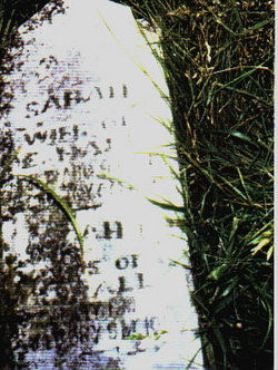
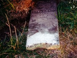
Sarah Hale Hall
| Birth | : | 25 Feb 1805 Greene County, Tennessee, USA |
| Death | : | 9 Aug 1851 Kilwinning, Scotland County, Missouri, USA |
| Burial | : | Lee-On-Solent Memorial, Lee-on-the-Solent, Gosport Borough, England |
| Coordinate | : | 50.8045110, -1.2068440 |
| Description | : | Sarah Hale md A. Endimyon Hall 10 Jan 1824 Greene Co. Tennessee. She was the daughter of Meshack Hale and Mary Kincheloe. Sarah had at age 46 years. Buried by her husband in the Hall family cemetery at Kilwinning, Scotland Co. Missouri |
frequently asked questions (FAQ):
-
Where is Sarah Hale Hall's memorial?
Sarah Hale Hall's memorial is located at: Lee-On-Solent Memorial, Lee-on-the-Solent, Gosport Borough, England.
-
When did Sarah Hale Hall death?
Sarah Hale Hall death on 9 Aug 1851 in Kilwinning, Scotland County, Missouri, USA
-
Where are the coordinates of the Sarah Hale Hall's memorial?
Latitude: 50.8045110
Longitude: -1.2068440
Family Members:
Spouse
Children

Flowers:


Nearby Cemetories:
1. Lee-On-Solent Memorial
Lee-on-the-Solent, Gosport Borough, England
Coordinate: 50.8045110, -1.2068440
2. St Mary the Virgin Churchyard
Gosport, Gosport Borough, England
Coordinate: 50.8112690, -1.1724800
3. Crofton Old Churchyard
Stubbington, Fareham Borough, England
Coordinate: 50.8344830, -1.2183660
4. St Edmund Churchyard
Stubbington, Fareham Borough, England
Coordinate: 50.8345130, -1.2185160
5. Crofton Cemetery
Stubbington, Fareham Borough, England
Coordinate: 50.8364160, -1.2173260
6. Ann's Hill Cemetery
Gosport, Gosport Borough, England
Coordinate: 50.7982670, -1.1549450
7. St Thomas the Apostle Churchyard
Gosport, Gosport Borough, England
Coordinate: 50.8137570, -1.1484570
8. St Mary Churchyard
Alverstoke, Gosport Borough, England
Coordinate: 50.7856760, -1.1480810
9. St John the Evangelist Churchyard
Gosport, Gosport Borough, England
Coordinate: 50.7995600, -1.1397800
10. St. Mark's Churchyard
Alverstoke, Gosport Borough, England
Coordinate: 50.7826800, -1.1436100
11. Posbrook Lane Cemetery
Titchfield, Fareham Borough, England
Coordinate: 50.8463100, -1.2403000
12. St. Peter's Churchyard
Titchfield, Fareham Borough, England
Coordinate: 50.8490620, -1.2330780
13. Turkish Naval Cemetery
Gosport, Gosport Borough, England
Coordinate: 50.7840710, -1.1383980
14. Clayhall Naval Cemetery
Gosport, Gosport Borough, England
Coordinate: 50.7833862, -1.1373420
15. Holy Trinity Churchyard
Fareham, Fareham Borough, England
Coordinate: 50.8522480, -1.1834370
16. St. Peter and St. Paul Churchyard
Fareham, Fareham Borough, England
Coordinate: 50.8556300, -1.1753200
17. Holy Trinity Churchyard
Gosport, Gosport Borough, England
Coordinate: 50.7930600, -1.1207620
18. Fareham Cemetery
Fareham, Fareham Borough, England
Coordinate: 50.8623050, -1.1795840
19. HMS Victory Ship
Portsmouth, Portsmouth Unitary Authority, England
Coordinate: 50.8017290, -1.1095590
20. Portchester Crematorium Gardens
Portchester, Fareham Borough, England
Coordinate: 50.8499680, -1.1382190
21. Roman Grove Cemetery
Portchester, Fareham Borough, England
Coordinate: 50.8384600, -1.1206200
22. Portsmouth Cathedral Churchyard
Portsmouth, Portsmouth Unitary Authority, England
Coordinate: 50.7904650, -1.1043720
23. Royal Garrison Churchyard
Portsmouth, Portsmouth Unitary Authority, England
Coordinate: 50.7890180, -1.1040520
24. Royal Garrison Church Churchyard
Plymouth, Plymouth Unitary Authority, England
Coordinate: 50.7889690, -1.1039650