
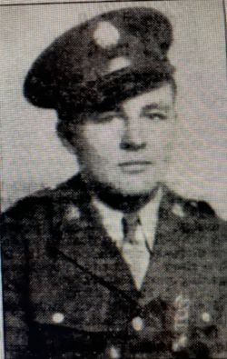

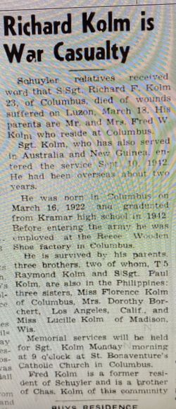
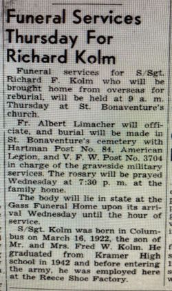
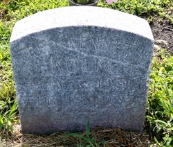
SGT Richard F. Kolm
| Birth | : | 16 Mar 1922 Columbus, Platte County, Nebraska, USA |
| Death | : | 18 Mar 1945 Philippines |
| Burial | : | St Swithun Churchyard, Long Bennington, South Kesteven District, England |
| Coordinate | : | 52.9856290, -0.7449190 |
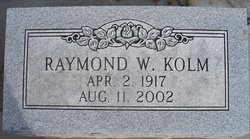
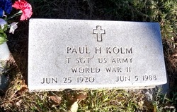
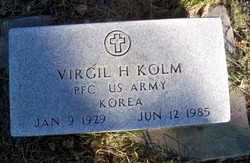
| Description | : | Son of Fred W. Kolm. WW II - US Army - Enlisted 9-10-1942 - 128th Infantry, 32nd Division - Staff Sgt., Ser#37262709 - Died of wounds received at Luzon, Phillipine Islands. ---------------------------- From the web site: http://www.usgennet.org/usa/ne/topic/resources/OLLibrary/Platte/pages/heros/hpcn0183.htm#arkluck Staff Sergeant Richard F. Kolm was born in Columbus, Nebraska, on March 16, 1922, and died March 18, 1945, from wounds suffered in action on Luzon. He was the son of Mr. and Mrs. Fred W. Kolm of Columbus, Nebraska. He had three brothers, Raymond KoIm and Paul KoIm, both in the service in the Philippines during World War II, and Virgil Kolm of Columbus, and three sisters, Mrs.... Read More |
frequently asked questions (FAQ):
-
Where is SGT Richard F. Kolm's memorial?
SGT Richard F. Kolm's memorial is located at: St Swithun Churchyard, Long Bennington, South Kesteven District, England.
-
When did SGT Richard F. Kolm death?
SGT Richard F. Kolm death on 18 Mar 1945 in Philippines
-
Where are the coordinates of the SGT Richard F. Kolm's memorial?
Latitude: 52.9856290
Longitude: -0.7449190
Family Members:
Parent
Siblings
Flowers:


Nearby Cemetories:
1. St Swithun Churchyard
Long Bennington, South Kesteven District, England
Coordinate: 52.9856290, -0.7449190
2. All Saints Churchyard
Westborough, South Kesteven District, England
Coordinate: 52.9892900, -0.7350100
3. St Peter Churchyard
Foston, South Kesteven District, England
Coordinate: 52.9771630, -0.7227360
4. St James Churchyard
Allington, South Kesteven District, England
Coordinate: 52.9525695, -0.7245301
5. All Saints Churchyard
Hougham, South Kesteven District, England
Coordinate: 52.9878240, -0.6806910
6. St Mary's Churchyard
Kilvington, Newark and Sherwood District, England
Coordinate: 52.9772500, -0.8092250
7. St. Mary the Virgin Churchyard
Bottesford, Melton Borough, England
Coordinate: 52.9434270, -0.8001460
8. St. Lawrence Churchyard
Sedgebrook, South Kesteven District, England
Coordinate: 52.9329460, -0.7256530
9. St Michael's Churchyard
Cotham, Newark and Sherwood District, England
Coordinate: 53.0199600, -0.8174700
10. St Peter's Churchyard
Flawborough, Rushcliffe Borough, England
Coordinate: 52.9773700, -0.8365800
11. St John the Baptist Churchyard
Muston, Melton Borough, England
Coordinate: 52.9315700, -0.7680600
12. St Mary & All Saints Churchyard
Shelton, Rushcliffe Borough, England
Coordinate: 52.9932200, -0.8389300
13. All Saints Churchyard
Fenton, South Kesteven District, England
Coordinate: 53.0462300, -0.6910100
14. St Mary's Churchyard
Orston, Rushcliffe Borough, England
Coordinate: 52.9622500, -0.8560300
15. St Sebastian Churchyard
Great Gonerby, South Kesteven District, England
Coordinate: 52.9329260, -0.6657700
16. St Giles Churchyard
Balderton, Newark and Sherwood District, England
Coordinate: 53.0553010, -0.7780750
17. Balderton Cemetery
Balderton, Newark and Sherwood District, England
Coordinate: 53.0539100, -0.7877400
18. Balderton Methodist Church
Newark-on-Trent, Newark and Sherwood District, England
Coordinate: 53.0551620, -0.7823410
19. All Saints Churchyard
Barrowby, South Kesteven District, England
Coordinate: 52.9186420, -0.6946810
20. All Saints Churchyard
Hough-on-the-Hill, South Kesteven District, England
Coordinate: 53.0069700, -0.6255100
21. St Mary & All Saints Churchyard
Hawksworth, Rushcliffe Borough, England
Coordinate: 52.9831700, -0.8800500
22. St Marys Churchyard
Syston, South Kesteven District, England
Coordinate: 52.9578420, -0.6172940
23. All Saints Churchyard
Hawton, Newark and Sherwood District, England
Coordinate: 53.0513890, -0.8258330
24. St Nicholas Churchyard
Barkston, South Kesteven District, England
Coordinate: 52.9629960, -0.6129380