
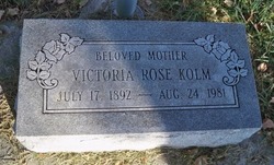
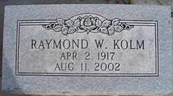
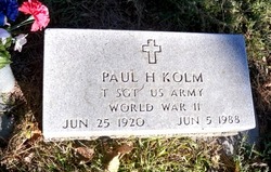
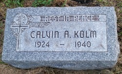
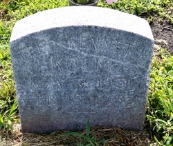
Victoria Rose Koziol Kolm
| Birth | : | 17 Jul 1892 Duncan, Platte County, Nebraska, USA |
| Death | : | 24 Aug 1981 Columbus, Platte County, Nebraska, USA |
| Burial | : | St Swithun Churchyard, Long Bennington, South Kesteven District, England |
| Coordinate | : | 52.9856290, -0.7449190 |
| Description | : | Married to Frederick W. Kolm ------------------------------------- Birth/baptismal records: St. Stanislaus Church - Duncan, Platte, Nebraska KOZIOL, Victoria Born: 17 July 1892 Baptized: 19 July 1892 Daughter of Joannes Koziol and Anna Bryg Godparents: Joseph Micek and Cath. Jelen Contributor: diaNEB (47466150) |
frequently asked questions (FAQ):
-
Where is Victoria Rose Koziol Kolm's memorial?
Victoria Rose Koziol Kolm's memorial is located at: St Swithun Churchyard, Long Bennington, South Kesteven District, England.
-
When did Victoria Rose Koziol Kolm death?
Victoria Rose Koziol Kolm death on 24 Aug 1981 in Columbus, Platte County, Nebraska, USA
-
Where are the coordinates of the Victoria Rose Koziol Kolm's memorial?
Latitude: 52.9856290
Longitude: -0.7449190
Family Members:
Parent
Siblings
Children
Flowers:


Nearby Cemetories:
1. St Swithun Churchyard
Long Bennington, South Kesteven District, England
Coordinate: 52.9856290, -0.7449190
2. All Saints Churchyard
Westborough, South Kesteven District, England
Coordinate: 52.9892900, -0.7350100
3. St Peter Churchyard
Foston, South Kesteven District, England
Coordinate: 52.9771630, -0.7227360
4. St James Churchyard
Allington, South Kesteven District, England
Coordinate: 52.9525695, -0.7245301
5. All Saints Churchyard
Hougham, South Kesteven District, England
Coordinate: 52.9878240, -0.6806910
6. St Mary's Churchyard
Kilvington, Newark and Sherwood District, England
Coordinate: 52.9772500, -0.8092250
7. St. Mary the Virgin Churchyard
Bottesford, Melton Borough, England
Coordinate: 52.9434270, -0.8001460
8. St. Lawrence Churchyard
Sedgebrook, South Kesteven District, England
Coordinate: 52.9329460, -0.7256530
9. St Michael's Churchyard
Cotham, Newark and Sherwood District, England
Coordinate: 53.0199600, -0.8174700
10. St Peter's Churchyard
Flawborough, Rushcliffe Borough, England
Coordinate: 52.9773700, -0.8365800
11. St John the Baptist Churchyard
Muston, Melton Borough, England
Coordinate: 52.9315700, -0.7680600
12. St Mary & All Saints Churchyard
Shelton, Rushcliffe Borough, England
Coordinate: 52.9932200, -0.8389300
13. All Saints Churchyard
Fenton, South Kesteven District, England
Coordinate: 53.0462300, -0.6910100
14. St Mary's Churchyard
Orston, Rushcliffe Borough, England
Coordinate: 52.9622500, -0.8560300
15. St Sebastian Churchyard
Great Gonerby, South Kesteven District, England
Coordinate: 52.9329260, -0.6657700
16. St Giles Churchyard
Balderton, Newark and Sherwood District, England
Coordinate: 53.0553010, -0.7780750
17. Balderton Cemetery
Balderton, Newark and Sherwood District, England
Coordinate: 53.0539100, -0.7877400
18. Balderton Methodist Church
Newark-on-Trent, Newark and Sherwood District, England
Coordinate: 53.0551620, -0.7823410
19. All Saints Churchyard
Barrowby, South Kesteven District, England
Coordinate: 52.9186420, -0.6946810
20. All Saints Churchyard
Hough-on-the-Hill, South Kesteven District, England
Coordinate: 53.0069700, -0.6255100
21. St Mary & All Saints Churchyard
Hawksworth, Rushcliffe Borough, England
Coordinate: 52.9831700, -0.8800500
22. St Marys Churchyard
Syston, South Kesteven District, England
Coordinate: 52.9578420, -0.6172940
23. All Saints Churchyard
Hawton, Newark and Sherwood District, England
Coordinate: 53.0513890, -0.8258330
24. St Nicholas Churchyard
Barkston, South Kesteven District, England
Coordinate: 52.9629960, -0.6129380