

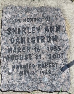
Shirley Ann Quam Dahlstrom
| Birth | : | 16 Mar 1935 Decorah, Winneshiek County, Iowa, USA |
| Death | : | 31 Aug 2007 Waukon, Allamakee County, Iowa, USA |
| Burial | : | Garner Cemetery, Council Bluffs, Pottawattamie County, USA |
| Coordinate | : | 41.2956161, -95.8001709 |
| Description | : | Shirley A. Dahlstrom, 72, of Waukon, IA, died Friday, August 31, 2007 at Northgate Care Center in Waukon, following a battle with cancer. Memorial services will be held Tuesday, September 4th at 11:00 am at St. John's Lutheran Church in Waukon, with Rev. Lynn G. Groe officiating. Friends may greet the family from 10:00 am until time of service at the church on Tuesday and again during a fellowship time immediately following the service. Shirley Ann Dahlstrom was born on March 16, 1935 in Decorah, IA, the daughter of Milford and Elsie (Nesset) Quam. She was baptized First Lutheran Church, confirmed... Read More |
frequently asked questions (FAQ):
-
Where is Shirley Ann Quam Dahlstrom's memorial?
Shirley Ann Quam Dahlstrom's memorial is located at: Garner Cemetery, Council Bluffs, Pottawattamie County, USA.
-
When did Shirley Ann Quam Dahlstrom death?
Shirley Ann Quam Dahlstrom death on 31 Aug 2007 in Waukon, Allamakee County, Iowa, USA
-
Where are the coordinates of the Shirley Ann Quam Dahlstrom's memorial?
Latitude: 41.2956161
Longitude: -95.8001709
Family Members:
Parent
Spouse
Siblings
Children
Flowers:


Nearby Cemetories:
1. Garner Cemetery
Council Bluffs, Pottawattamie County, USA
Coordinate: 41.2956161, -95.8001709
2. Green Valley Cemetery
Council Bluffs, Pottawattamie County, USA
Coordinate: 41.2743988, -95.8225021
3. Saint Joseph Cemetery
Council Bluffs, Pottawattamie County, USA
Coordinate: 41.2722015, -95.8208008
4. Cedar Lawn Cemetery
Council Bluffs, Pottawattamie County, USA
Coordinate: 41.2694016, -95.8182983
5. Walnut Hill Cemetery
Council Bluffs, Pottawattamie County, USA
Coordinate: 41.2719002, -95.8255997
6. Bikhor Cholim Cemetery
Council Bluffs, Pottawattamie County, USA
Coordinate: 41.2703670, -95.8229350
7. Oak Hill Cemetery
Council Bluffs, Pottawattamie County, USA
Coordinate: 41.2700900, -95.8226400
8. Ridgewood Cemetery
Council Bluffs, Pottawattamie County, USA
Coordinate: 41.2694016, -95.8272018
9. Memorial Park Cemetery
Council Bluffs, Pottawattamie County, USA
Coordinate: 41.2644005, -95.8261032
10. Gregg Cemetery
Weston, Pottawattamie County, USA
Coordinate: 41.3330000, -95.7931000
11. Evans Cemetery
Crescent, Pottawattamie County, USA
Coordinate: 41.3255997, -95.8368988
12. Clark Cemetery
Pottawattamie County, USA
Coordinate: 41.2551610, -95.8223390
13. Fairview Cemetery
Council Bluffs, Pottawattamie County, USA
Coordinate: 41.2703018, -95.8480988
14. Stoker-Graybill Cemetery
Council Bluffs, Pottawattamie County, USA
Coordinate: 41.2532620, -95.7751770
15. Hazel Dell Cemetery
Council Bluffs, Pottawattamie County, USA
Coordinate: 41.3489723, -95.7939911
16. Saint Columbanus Cemetery
Weston, Pottawattamie County, USA
Coordinate: 41.3429440, -95.7435260
17. Maple Grove Cemetery
Council Bluffs, Pottawattamie County, USA
Coordinate: 41.2265560, -95.8187100
18. Crescent Cemetery
Crescent, Pottawattamie County, USA
Coordinate: 41.3664894, -95.8566208
19. Lewis Township Cemetery
Council Bluffs, Pottawattamie County, USA
Coordinate: 41.2117004, -95.7938995
20. Downsville Cemetery
Pottawattamie County, USA
Coordinate: 41.3502998, -95.7039032
21. Council Point Cemetery
Council Bluffs, Pottawattamie County, USA
Coordinate: 41.2110830, -95.8788610
22. Pottawattamie County Home Cemetery
McClelland, Pottawattamie County, USA
Coordinate: 41.3269400, -95.6691738
23. Trinity Cathedral Columbarium
Omaha, Douglas County, USA
Coordinate: 41.2603900, -95.9393660
24. Hardin Township Cemetery
McClelland, Pottawattamie County, USA
Coordinate: 41.2949982, -95.6513977