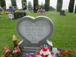
Shirley Mae Nierling
| Birth | : | 24 Feb 1937 Waukon, Allamakee County, Iowa, USA |
| Death | : | 4 Apr 2022 Mabel, Fillmore County, Minnesota, USA |
| Burial | : | St. John the Baptist Churchyard, Heaton Mersey, Metropolitan Borough of Stockport, England |
| Coordinate | : | 53.4124526, -2.2064749 |
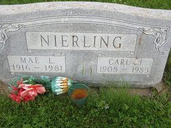
| Description | : | Shirley Mae Nierling, age 85 of Dorchester, passed away April 4, 2022 at Green Lea Manor in Mabel, Minnesota She was born Feb. 24, 1937 to Carl and Mae (Dresselhaus) Nierling. She attended rural Dorchester schools. Shirley lived in Dorchester and rural Spring Grove. She farmed two farms, one in Wilmington Township, and the other in Allamakee Township. She had also worked for twenty-two years as a nurses aid in Spring Grove and Mabel, Mn and Postville, IA hospitals. Shirley enjoyed Square dancing, going for drives and looming rag rugs. She was... Read More |
frequently asked questions (FAQ):
-
Where is Shirley Mae Nierling's memorial?
Shirley Mae Nierling's memorial is located at: St. John the Baptist Churchyard, Heaton Mersey, Metropolitan Borough of Stockport, England.
-
When did Shirley Mae Nierling death?
Shirley Mae Nierling death on 4 Apr 2022 in Mabel, Fillmore County, Minnesota, USA
-
Where are the coordinates of the Shirley Mae Nierling's memorial?
Latitude: 53.4124526
Longitude: -2.2064749
Family Members:
Parent
Flowers:
Nearby Cemetories:
1. St. John the Baptist Churchyard
Heaton Mersey, Metropolitan Borough of Stockport, England
Coordinate: 53.4124526, -2.2064749
2. Heaton Mersey Congregational Churchyard
Stockport, Metropolitan Borough of Stockport, England
Coordinate: 53.4128680, -2.2038150
3. Mill Lane Cemetery
Cheadle, Metropolitan Borough of Stockport, England
Coordinate: 53.3992000, -2.2150800
4. Parsonage Gardens
Didsbury, Metropolitan Borough of Manchester, England
Coordinate: 53.4094440, -2.2302780
5. St James Churchyard
Didsbury, Metropolitan Borough of Manchester, England
Coordinate: 53.4088737, -2.2330498
6. St Mary's Churchyard
Cheadle, Metropolitan Borough of Stockport, England
Coordinate: 53.3944820, -2.2176205
7. Cheadle Cemetery
Cheadle, Metropolitan Borough of Stockport, England
Coordinate: 53.3927610, -2.2054690
8. St. Paul's Churchyard
Portwood, Metropolitan Borough of Stockport, England
Coordinate: 53.4215604, -2.1717953
9. Christ Church
Heaton Norris, Metropolitan Borough of Stockport, England
Coordinate: 53.4144000, -2.1678000
10. Saint Thomas the Apostle Heaton Chapel
Heaton Norris, Metropolitan Borough of Stockport, England
Coordinate: 53.4297783, -2.1797558
11. St. Paul's Churchyard
Withington, Metropolitan Borough of Manchester, England
Coordinate: 53.4324900, -2.2280790
12. Wesleyan Chapel
Edgeley, Metropolitan Borough of Stockport, England
Coordinate: 53.4019700, -2.1673860
13. St. Peter's Churchyard
Stockport, Metropolitan Borough of Stockport, England
Coordinate: 53.4105000, -2.1587000
14. St. Mary's Churchyard
Stockport, Metropolitan Borough of Stockport, England
Coordinate: 53.4112340, -2.1555140
15. Stockport Quaker Burial Ground (Defunct)
Stockport, Metropolitan Borough of Stockport, England
Coordinate: 53.4096205, -2.1555406
16. St Thomas Churchyard
Stockport, Metropolitan Borough of Stockport, England
Coordinate: 53.4036000, -2.1550000
17. The Parish Church of Saint Peter
Stockport, Metropolitan Borough of Stockport, England
Coordinate: 53.4084880, -2.1492930
18. Willow Grove Cemetery
Stockport, Metropolitan Borough of Stockport, England
Coordinate: 53.4252900, -2.1508100
19. Southern Cemetery
Chorlton-Cum-Hardy, Metropolitan Borough of Manchester, England
Coordinate: 53.4278060, -2.2611000
20. Stockport Cemetery and Crematorium
Stockport, Metropolitan Borough of Stockport, England
Coordinate: 53.3979110, -2.1511430
21. St Elisabeth Church
Reddish, Metropolitan Borough of Stockport, England
Coordinate: 53.4379400, -2.1633950
22. St James Churchyard
Rusholme, Metropolitan Borough of Manchester, England
Coordinate: 53.4490050, -2.2151450
23. Manchester Crematorium
Manchester, Metropolitan Borough of Manchester, England
Coordinate: 53.4306520, -2.2669990
24. Former Saint Johns Churchyard
Longsight, Metropolitan Borough of Manchester, England
Coordinate: 53.4570760, -2.2025800


