
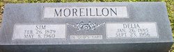
Simeon Marion “Sim” Moreillon
| Birth | : | 26 Feb 1879 Switzerland County, Indiana, USA |
| Death | : | 8 May 1960 Madison, Jefferson County, Indiana, USA |
| Burial | : | All Saints Churchyard, Godshill, Isle of Wight Unitary Authority, England |
| Coordinate | : | 50.6336900, -1.2558300 |
frequently asked questions (FAQ):
-
Where is Simeon Marion “Sim” Moreillon's memorial?
Simeon Marion “Sim” Moreillon's memorial is located at: All Saints Churchyard, Godshill, Isle of Wight Unitary Authority, England.
-
When did Simeon Marion “Sim” Moreillon death?
Simeon Marion “Sim” Moreillon death on 8 May 1960 in Madison, Jefferson County, Indiana, USA
-
Where are the coordinates of the Simeon Marion “Sim” Moreillon's memorial?
Latitude: 50.6336900
Longitude: -1.2558300
Family Members:
Parent
Spouse

Siblings
Children


Nearby Cemetories:
1. All Saints Churchyard
Godshill, Isle of Wight Unitary Authority, England
Coordinate: 50.6336900, -1.2558300
2. Billingham Manor
Newport, Isle of Wight Unitary Authority, England
Coordinate: 50.6347663, -1.3140535
3. Whitwell New Burial Ground
Whitwell, Isle of Wight Unitary Authority, England
Coordinate: 50.5943366, -1.2689275
4. St Olave's Churchyard
Gatcombe, Isle of Wight Unitary Authority, England
Coordinate: 50.6636110, -1.3041670
5. Old Church of St Lawrence
Ventnor, Isle of Wight Unitary Authority, England
Coordinate: 50.5871078, -1.2438191
6. Parish Church of St. Lawrence
Ventnor, Isle of Wight Unitary Authority, England
Coordinate: 50.5858807, -1.2436714
7. Niton Baptist Church
Ventnor, Isle of Wight Unitary Authority, England
Coordinate: 50.5850100, -1.2864900
8. Shanklin Cemetery
Sandown, Isle of Wight Unitary Authority, England
Coordinate: 50.6445083, -1.1742694
9. Shanklin Cemetery
Shanklin, Isle of Wight Unitary Authority, England
Coordinate: 50.6441740, -1.1738343
10. Lake Cemetery
Lake, Isle of Wight Unitary Authority, England
Coordinate: 50.6498713, -1.1734786
11. St Boniface Bonchurch Churchyard
Bonchurch, Isle of Wight Unitary Authority, England
Coordinate: 50.6000880, -1.1867990
12. St Boniface Old Churchyard
Bonchurch, Isle of Wight Unitary Authority, England
Coordinate: 50.5988889, -1.1850000
13. Carisbrooke Priory
Carisbrooke, Isle of Wight Unitary Authority, England
Coordinate: 50.6859710, -1.3070000
14. Christ Churchyard
Sandown, Isle of Wight Unitary Authority, England
Coordinate: 50.6521319, -1.1621056
15. St Peter New Churchyard
Shorwell, Isle of Wight Unitary Authority, England
Coordinate: 50.6433100, -1.3541400
16. St Peter's Parish Church
Shorwell, Isle of Wight Unitary Authority, England
Coordinate: 50.6449290, -1.3545580
17. Carisbrooke Cemetery
Carisbrooke, Isle of Wight Unitary Authority, England
Coordinate: 50.6882160, -1.3083040
18. St Thomas Church
Newport, Isle of Wight Unitary Authority, England
Coordinate: 50.6997610, -1.2940130
19. Newport Cemetery
Newport, Isle of Wight Unitary Authority, England
Coordinate: 50.7041360, -1.2887540
20. St Paul's Cemetery
Newport, Isle of Wight Unitary Authority, England
Coordinate: 50.7072300, -1.2827400
21. Parkhurst Military Cemetery
Newport, Isle of Wight Unitary Authority, England
Coordinate: 50.7084440, -1.3044120
22. Isle of Wight Workhouse Burial Ground
Carisbrooke, Isle of Wight Unitary Authority, England
Coordinate: 50.7112150, -1.2979810
23. St Peter's
Havenstreet, Isle of Wight Unitary Authority, England
Coordinate: 50.7095580, -1.2063290
24. St Mary the Virgin Churchyard
Brading, Isle of Wight Unitary Authority, England
Coordinate: 50.6824400, -1.1429600