| Birth | : | Apr 1855 |
| Death | : | 28 Mar 1931 |
| Burial | : | Druid Ridge Cemetery, Pikesville, Baltimore County, USA |
| Coordinate | : | 39.3793800, -76.7275700 |
| Plot | : | Block 75, Section 277D |
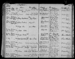
| Description | : | Rosebud Episcopal Mission Church Records, Book G, File #007856516, Image 364 of 554. Record states he is 73 years old and the cause of death is a stroke. He was buried 30 Mar 1931 with J.B. DeCory officiating at the funeral. He was found to be listed as Smith Gunhammer also. Indian Census Rolls, 1885-1940, Rosebud, 1905: Little Money, 49, head Zanetta, 49, wife Rebecca, 16, daughter Nancy, 14, daughter Celia, 10, daughter Charles, 9, son Amos, 5 1/2 years old, son Philomene, 2, daughter Indian Census Rolls 1885-1940 Rosebud 1929: "Little Money, b 1855, head " |
frequently asked questions (FAQ):
-
Where is Smith Cleveland “Mazaskala” Little Money's memorial?
Smith Cleveland “Mazaskala” Little Money's memorial is located at: Druid Ridge Cemetery, Pikesville, Baltimore County, USA.
-
When did Smith Cleveland “Mazaskala” Little Money death?
Smith Cleveland “Mazaskala” Little Money death on 28 Mar 1931 in
-
Where are the coordinates of the Smith Cleveland “Mazaskala” Little Money's memorial?
Latitude: 39.3793800
Longitude: -76.7275700
Family Members:
Spouse
Children
Flowers:
Nearby Cemetories:
1. Druid Ridge Cemetery
Pikesville, Baltimore County, USA
Coordinate: 39.3793800, -76.7275700
2. Saint Charles Borromeo Church Cemetery
Pikesville, Baltimore County, USA
Coordinate: 39.3738100, -76.7254000
3. Mettam Memorial Baptist Church Cemetery
Pikesville, Baltimore County, USA
Coordinate: 39.3780700, -76.7197300
4. Stone Chapel United Methodist Church Cemetery
Pikesville, Baltimore County, USA
Coordinate: 39.3934000, -76.7407500
5. Howard Graveyard at Grayrock
Pikesville, Baltimore County, USA
Coordinate: 39.3954560, -76.7367020
6. Holy Trinity Monastery Cemetery
Pikesville, Baltimore County, USA
Coordinate: 39.3971991, -76.7277734
7. Croxall Family Cemetery
Baltimore County, USA
Coordinate: 39.3968735, -76.7207870
8. Saint Thomas Cemetery
Milford, Baltimore County, USA
Coordinate: 39.3605995, -76.7735977
9. Mount Olive Cemetery
Randallstown, Baltimore County, USA
Coordinate: 39.3623400, -76.7769800
10. Arlington Chizuk Amuno Cemetery
Baltimore, Baltimore City, USA
Coordinate: 39.3442001, -76.6971970
11. Hook Family Cemetery
Bare Hills, Baltimore County, USA
Coordinate: 39.3886600, -76.6653300
12. Rosewood State Hospital Cemetery
Owings Mills, Baltimore County, USA
Coordinate: 39.4215500, -76.7619000
13. Saint Thomas Episcopal Church Cemetery
Owings Mills, Baltimore County, USA
Coordinate: 39.4215500, -76.7619000
14. Resurrection Acres Cemetery
Randallstown, Baltimore County, USA
Coordinate: 39.3353340, -76.7691617
15. Bihy Cemetery
Baltimore County, USA
Coordinate: 39.3278008, -76.7506027
16. Cockey-Reed Cemetery
Greenspring, Baltimore County, USA
Coordinate: 39.4196400, -76.6671300
17. Shaarei Tfiloh Cemetery
Baltimore County, USA
Coordinate: 39.3163700, -76.7175700
18. Har Sinai Cemetery
Owings Mills, Baltimore County, USA
Coordinate: 39.4353900, -76.7683800
19. Garrison Forest Cemetery
Owings Mills, Baltimore County, USA
Coordinate: 39.4363000, -76.7674800
20. Saint Johns AME Chapel Cemetery
Ruxton, Baltimore County, USA
Coordinate: 39.3944300, -76.6458400
21. Saters Baptist Historical Church Cemetery
Timonium, Baltimore County, USA
Coordinate: 39.4362920, -76.6870810
22. Carrolls-Gills United Methodist Church Cemetery
Lutherville, Baltimore County, USA
Coordinate: 39.4465300, -76.7185900
23. Holy Family Cemetery
Randallstown, Baltimore County, USA
Coordinate: 39.3752800, -76.8156000
24. Garrison Forest Veterans Cemetery
Owings Mills, Baltimore County, USA
Coordinate: 39.4407600, -76.7680800

