
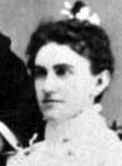


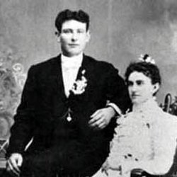
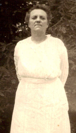
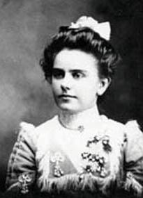
Sophia Line Anna Margarethe Seifert Zahrndt
| Birth | : | 7 Dec 1876 Clayton Center, Clayton County, Iowa, USA |
| Death | : | 27 Sep 1947 Elkader, Clayton County, Iowa, USA |
| Burial | : | Spalding Cemetery, Spalding, South Holland District, England |
| Coordinate | : | 52.7954960, -0.1519390 |
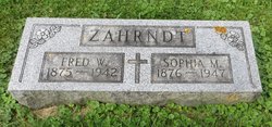
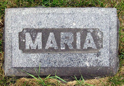
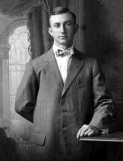
| Inscription | : | ZAHRNDT Fred W. 1875 - 1942 Sophia M. 1876 - 1947 |
| Description | : | Extract from the 1880 Census: Name: Sophie Seifert Age: 4 Estimated birth year: 1876 Birthplace: Iowa Race: white Sex: female Relationship to head-of-household: daughter Home in 1880: Read, Clayton, Iowa Marital status: single Father's birthplace: Braunschweig Mother's birthplace: Bavaria Occupation: none Siblings living at home: Anna (age 12), Louisa (10), Marie (8), Amelia (6), and Friedrich (1) Census place: Read, Clayton, Iowa; Roll: T9_333; Family History Film: 1254333; Page: 522.1000; Enumeration District: 145; Image: 0687 Date: 1 Jun 1880 Extract from the 1900 Census: Name: Sophia Zahrndt Age at last birthday: 23 Date of birth: Dec 1876 Birthplace: Iowa Race: white Sex: female Relationship to head-of-house: wife Home in 1900: Cox Creek, Clayton, Iowa Marital status: married Number of years of marriage: 1 Number of children: 0 Number... Read More |
frequently asked questions (FAQ):
-
Where is Sophia Line Anna Margarethe Seifert Zahrndt's memorial?
Sophia Line Anna Margarethe Seifert Zahrndt's memorial is located at: Spalding Cemetery, Spalding, South Holland District, England.
-
When did Sophia Line Anna Margarethe Seifert Zahrndt death?
Sophia Line Anna Margarethe Seifert Zahrndt death on 27 Sep 1947 in Elkader, Clayton County, Iowa, USA
-
Where are the coordinates of the Sophia Line Anna Margarethe Seifert Zahrndt's memorial?
Latitude: 52.7954960
Longitude: -0.1519390
Family Members:
Parent
Spouse
Siblings


Children


Nearby Cemetories:
1. Spalding Cemetery
Spalding, South Holland District, England
Coordinate: 52.7954960, -0.1519390
2. St Paul's Churchyard
Spalding, South Holland District, England
Coordinate: 52.7969559, -0.1305557
3. St. Mary's Churchyard
Pinchbeck, South Holland District, England
Coordinate: 52.8135340, -0.1589220
4. St. Laurence Churchyard
Surfleet, South Holland District, England
Coordinate: 52.8369500, -0.1436110
5. St Bartholomew's Church West Pinchbeck
Pinchbeck, South Holland District, England
Coordinate: 52.8080873, -0.2216285
6. Surfleet Cemetery
Surfleet, South Holland District, England
Coordinate: 52.8391670, -0.1383330
7. St. Mary's Cemetery
Weston, South Holland District, England
Coordinate: 52.8078662, -0.0809039
8. South Lincolnshire Crematorium
Surfleet, South Holland District, England
Coordinate: 52.8451100, -0.1475110
9. All Saints Churchyard
Moulton, South Holland District, England
Coordinate: 52.7990056, -0.0629691
10. Moulton Cemetery
Moulton, South Holland District, England
Coordinate: 52.8017000, -0.0632400
11. St Gilbert and St Hugh Churchyard
Gosberton Clough, South Holland District, England
Coordinate: 52.8518081, -0.2166268
12. St. Mary's Churchyard
Whaplode, South Holland District, England
Coordinate: 52.7974840, -0.0385520
13. Gosberton Baptist Church
Gosberton, South Holland District, England
Coordinate: 52.8651820, -0.1533940
14. Gosberton Cemetery
Gosberton, South Holland District, England
Coordinate: 52.8659400, -0.1623000
15. St. Peter and St. Paul Churchyard
Gosberton, South Holland District, England
Coordinate: 52.8690870, -0.1629740
16. Whaplode Cemetery
Whaplode, South Holland District, England
Coordinate: 52.8016190, -0.0281347
17. St. Margaret's Churchyard
Quadring, South Holland District, England
Coordinate: 52.8903400, -0.1819700
18. All Saints Churchyard
Holbeach, South Holland District, England
Coordinate: 52.8036140, 0.0142530
19. Holbeach Cemetery
Holbeach, South Holland District, England
Coordinate: 52.8062100, 0.0171500
20. St. John's Churchyard
Holbeach, South Holland District, England
Coordinate: 52.7457510, -0.0024000
21. All Saints Churchyard
Fosdyke, Boston Borough, England
Coordinate: 52.8811100, -0.0469440
22. Fosdyke Village Cemetery
Fosdyke, Boston Borough, England
Coordinate: 52.8808330, -0.0447220
23. Sutterton Village Cemetery
Sutterton, Boston Borough, England
Coordinate: 52.8994440, -0.0900000
24. St. John the Baptist Churchyard
Whaplode Drove, South Holland District, England
Coordinate: 52.7034435, -0.0476688