

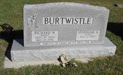
Stephanie A. “Stephie” Hubel Burtwistle
| Birth | : | 4 Aug 1927 Nebraska, USA |
| Death | : | 7 Dec 2013 Neligh, Antelope County, Nebraska, USA |
| Burial | : | St. John the Baptist Churchyard, Bentham, Craven District, England |
| Coordinate | : | 54.1180880, -2.5454540 |
| Plot | : | Block 2, Lot 27 |
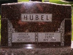
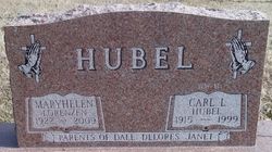
| Inscription | : | Parents of Linda, Betty, Rich, Jim |
frequently asked questions (FAQ):
-
Where is Stephanie A. “Stephie” Hubel Burtwistle's memorial?
Stephanie A. “Stephie” Hubel Burtwistle's memorial is located at: St. John the Baptist Churchyard, Bentham, Craven District, England.
-
When did Stephanie A. “Stephie” Hubel Burtwistle death?
Stephanie A. “Stephie” Hubel Burtwistle death on 7 Dec 2013 in Neligh, Antelope County, Nebraska, USA
-
Where are the coordinates of the Stephanie A. “Stephie” Hubel Burtwistle's memorial?
Latitude: 54.1180880
Longitude: -2.5454540
Family Members:
Parent
Spouse
Siblings

Flowers:


Nearby Cemetories:
1. St. John the Baptist Churchyard
Bentham, Craven District, England
Coordinate: 54.1180880, -2.5454540
2. Friends Burial Group
Bentham, Craven District, England
Coordinate: 54.1265450, -2.5374290
3. St Margaret Churchyard
Bentham, Craven District, England
Coordinate: 54.1146000, -2.5087300
4. All Saints Churchyard
Burton-in-Lonsdale, Craven District, England
Coordinate: 54.1437630, -2.5357130
5. St James the Less Churchyard
Tatham, City of Lancaster, England
Coordinate: 54.1190100, -2.6043200
6. Church of the Good Shepherd Churchyard
Tatham, City of Lancaster, England
Coordinate: 54.0830170, -2.5301250
7. Holy Trinity Churchyard
Wray, City of Lancaster, England
Coordinate: 54.1022960, -2.6081510
8. St Wilfrids Churchyard
Melling, City of Lancaster, England
Coordinate: 54.1346900, -2.6165100
9. St John The Baptist Churchyard
Tunstall, City of Lancaster, England
Coordinate: 54.1596600, -2.5924200
10. St. Margaret's Churchyard
Hornby, City of Lancaster, England
Coordinate: 54.1114000, -2.6362000
11. St Oswald Churchyard
Thornton-in-Lonsdale, Craven District, England
Coordinate: 54.1573600, -2.4830810
12. St John The Baptist Churchyard
Arkholme, City of Lancaster, England
Coordinate: 54.1406220, -2.6307800
13. St. Wilfred Priory
Hornby, City of Lancaster, England
Coordinate: 54.1143640, -2.6405490
14. St Mary Churchyard
Ingleton, Craven District, England
Coordinate: 54.1540480, -2.4682980
15. Ingleton Cemetery
Ingleton, Craven District, England
Coordinate: 54.1495470, -2.4569780
16. St. John The Evangelist Churchyard
Gressingham, City of Lancaster, England
Coordinate: 54.1233910, -2.6557800
17. Saint Peter's Churchyard
Leck, City of Lancaster, England
Coordinate: 54.1836860, -2.5485980
18. St. Chad's Churchyard
Claughton, City of Lancaster, England
Coordinate: 54.0931310, -2.6643990
19. St. Matthew's Churchyard
Keasden, Craven District, England
Coordinate: 54.0945680, -2.4245830
20. St. Michael the Archangel Churchyard
Whittington, City of Lancaster, England
Coordinate: 54.1807620, -2.6148790
21. St. Saviour's Church
Halton, City of Lancaster, England
Coordinate: 54.1025610, -2.6891750
22. Clapham Parish Cemetery
Clapham, Craven District, England
Coordinate: 54.1110400, -2.3963100
23. St James Churchyard
Clapham, Craven District, England
Coordinate: 54.1202400, -2.3904970
24. St Mary the Virgin Churchyard
Kirkby Lonsdale, South Lakeland District, England
Coordinate: 54.2036550, -2.5976790