Steven Lee Ulven
| Birth | : | 26 Jun 1948 Mapleton, Monona County, Iowa, USA |
| Death | : | 16 Jul 2005 Yutan, Saunders County, Nebraska, USA |
| Burial | : | Saint John the Baptist Churchyard, North Cheriton, South Somerset District, England |
| Coordinate | : | 51.0309000, -2.4474000 |
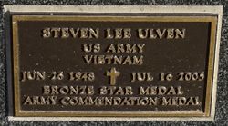
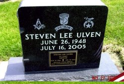
| Inscription | : | Steven Lee Ulven U.S. Army Vietnam June 26, 1948 - Jul 16, 2005 Bronze Star Medal Army Commendation Medal |
| Description | : | OMAHA WORLD-HERALD DATED JULY 19, 2005 ULVEN - Steven L., age 57, of Yutan, NE, passed away July 16, 2005. Served in U.S. Army, Vietnam. Member of the Fremont Masons Member of the Yutan VFW Chapter, Member of the Shriners of North America. Survived by sons, Eric and Sandy Ulven, Mark Ulven, Evan Ulven; daughter, Ingrid Ulven; sisters, Pamela and Dick Leinbaugh, Debbie Ulven; brother, Brad and Dianne Ulven. Graveside Service Wed. 1:30 PM Dunlap Iowa Cemetery. No Visitation. Please send flowers to Bramen Mortuary. ... Read More |
frequently asked questions (FAQ):
-
Where is Steven Lee Ulven's memorial?
Steven Lee Ulven's memorial is located at: Saint John the Baptist Churchyard, North Cheriton, South Somerset District, England.
-
When did Steven Lee Ulven death?
Steven Lee Ulven death on 16 Jul 2005 in Yutan, Saunders County, Nebraska, USA
-
Where are the coordinates of the Steven Lee Ulven's memorial?
Latitude: 51.0309000
Longitude: -2.4474000
Family Members:
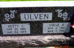
Parent
Flowers:
Nearby Cemetories:
1. Saint John the Baptist Churchyard
North Cheriton, South Somerset District, England
Coordinate: 51.0309000, -2.4474000
2. North Cheriton Cemetery
North Cheriton, South Somerset District, England
Coordinate: 51.0284840, -2.4389150
3. Saint Nicholas Churchyard
Holton, South Somerset District, England
Coordinate: 51.0401280, -2.4502641
4. St. Peter & St. Paul Churchyard
Maperton, South Somerset District, England
Coordinate: 51.0335993, -2.4686628
5. Saint John's Churchyard
Horsington, South Somerset District, England
Coordinate: 51.0126300, -2.4238400
6. St. Michael's Churchyard
Blackford, South Somerset District, England
Coordinate: 51.0336960, -2.4892290
7. Saint Peter & Saint Paul Churchyard
Charlton Horethorne, South Somerset District, England
Coordinate: 51.0060200, -2.4790100
8. St. Nicholas' Churchyard
Bratton Seymour, South Somerset District, England
Coordinate: 51.0679406, -2.4625400
9. Blessed Virgin Mary Churchyard
Compton Pauncefoot, South Somerset District, England
Coordinate: 51.0336770, -2.5089430
10. Saint Stephen Churchyard
Charlton Musgrove, South Somerset District, England
Coordinate: 51.0678630, -2.4008550
11. St Michael Churchyard
North Cadbury, South Somerset District, England
Coordinate: 51.0416670, -2.5213610
12. Corton Denham Cemetery
Corton Denham, South Somerset District, England
Coordinate: 51.0015810, -2.5202380
13. Saint Andrew Churchyard
Corton Denham, South Somerset District, England
Coordinate: 51.0015790, -2.5203100
14. All Saints Churchyard
Poyntington, West Dorset District, England
Coordinate: 50.9782070, -2.4997530
15. Civic Cemetery
Buckhorn Weston, North Dorset District, England
Coordinate: 51.0212440, -2.3484600
16. St Leonard Churchyard and Extension
Pitcombe, South Somerset District, England
Coordinate: 51.0925600, -2.4684600
17. St John The Baptist Churchyard
Buckhorn Weston, North Dorset District, England
Coordinate: 51.0212870, -2.3481780
18. St Lawrence Churchyard
Cucklington, South Somerset District, England
Coordinate: 51.0487190, -2.3507950
19. St Nicholas Churchyard
Henstridge, South Somerset District, England
Coordinate: 50.9762610, -2.3957980
20. Milborne Port Cemetery
Milborne Port, South Somerset District, England
Coordinate: 50.9662940, -2.4605880
21. Saint John's Churchyard
Charlton Musgrove, South Somerset District, England
Coordinate: 51.0840723, -2.3869787
22. Milborne Port Churchyard
Milborne Port, South Somerset District, England
Coordinate: 50.9653900, -2.4621550
23. St Peter Churchyard
Redlynch, South Somerset District, England
Coordinate: 51.0983279, -2.4299457
24. Castle Cary Cemetery
Castle Cary, South Somerset District, England
Coordinate: 51.0803800, -2.5223600


