
| Birth | : | Sep 1880 Coyville, Wilson County, Kansas, USA |
| Death | : | 17 Apr 1951 Council Bluffs, Pottawattamie County, Iowa, USA |
| Burial | : | Rose Hill Memorial Gardens, Missouri Valley, Harrison County, USA |
| Coordinate | : | 41.5656000, -95.8897000 |
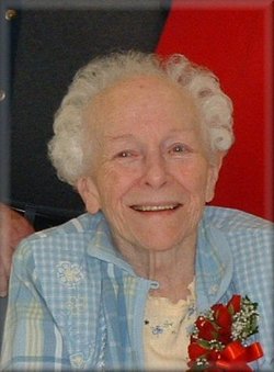
| Description | : | MISSOURI VALLEY - Services will be held at 2:30 p.m. Friday at the Hardy-Yutesler funeral home for Mrs. Susie Olinger, 70, of Modale who died Tuesday afternoon in a Council Bluffs hospital. The Rev. Raymond Walker will officiate. A Modale resident 60 years, Mrs. Olinger is survived by a daughter, Mrs. E. U. Kraushaar, Modale; son, Fred, Modale; four sisters, Mrs. Florence Fountain, Modale; Mrs. Henry Bostwick, Honey Creek; Mrs. Idyle House, Onawa; Mrs. John Erway, Missouri Valley; and three brothers, Britt Stokes, Blackfoot, Idaho; Ira Stokes, Fairfield, and Roy of Council Bluffs. There are also four grandchildren. Burial will be at Rose... Read More |
frequently asked questions (FAQ):
-
Where is Susie Emma Stokes Olinger's memorial?
Susie Emma Stokes Olinger's memorial is located at: Rose Hill Memorial Gardens, Missouri Valley, Harrison County, USA.
-
When did Susie Emma Stokes Olinger death?
Susie Emma Stokes Olinger death on 17 Apr 1951 in Council Bluffs, Pottawattamie County, Iowa, USA
-
Where are the coordinates of the Susie Emma Stokes Olinger's memorial?
Latitude: 41.5656000
Longitude: -95.8897000
Family Members:
Parent

Spouse
Siblings
Children
Flowers:


Nearby Cemetories:
1. Rose Hill Memorial Gardens
Missouri Valley, Harrison County, USA
Coordinate: 41.5656000, -95.8897000
2. Mount Carmel Cemetery
Missouri Valley, Harrison County, USA
Coordinate: 41.5675011, -95.8897018
3. Champan Frazier Cemetery
Harrison County, USA
Coordinate: 41.5773500, -95.8933500
4. Hurleys Evergreen Cemetery
Harrison County, USA
Coordinate: 41.5700989, -95.8618698
5. Frazier Cemetery
Missouri Valley, Harrison County, USA
Coordinate: 41.5932999, -95.8375015
6. Oak Grove Cemetery
Missouri Valley, Harrison County, USA
Coordinate: 41.5167007, -95.8649979
7. Calhoun Cemetery
Calhoun, Harrison County, USA
Coordinate: 41.6391983, -95.8938980
8. Branson Cemetery
Loveland, Pottawattamie County, USA
Coordinate: 41.4846992, -95.8606033
9. Linnwood Cemetery
Harrison County, USA
Coordinate: 41.5589200, -95.7502100
10. Crook Cemetery
Honey Creek, Pottawattamie County, USA
Coordinate: 41.4581330, -95.8737000
11. Saint Bridgets Cemetery
Honey Creek, Pottawattamie County, USA
Coordinate: 41.4664001, -95.8289032
12. Logan Cemetery
Logan, Harrison County, USA
Coordinate: 41.6487579, -95.7843170
13. Harris Grove Cemetery
Beebeetown, Harrison County, USA
Coordinate: 41.5782928, -95.7262192
14. Magnolia Cemetery
Magnolia, Harrison County, USA
Coordinate: 41.6903000, -95.8799973
15. Allen Cemetery
Pottawattamie County, USA
Coordinate: 41.4427986, -95.8550034
16. Saint Bridgets Cemetery
Magnolia, Harrison County, USA
Coordinate: 41.6915660, -95.8812480
17. Grange Cemetery
Honey Creek, Pottawattamie County, USA
Coordinate: 41.4446678, -95.8034668
18. Hauger-Rumbaugh Cemetery
Modale, Harrison County, USA
Coordinate: 41.6388797, -96.0502906
19. Silver Hill Cemetery
Harrison County, USA
Coordinate: 41.6897011, -95.7919006
20. Reels Cemetery
Crescent, Pottawattamie County, USA
Coordinate: 41.4234100, -95.8321700
21. Yutesler Cemetery
Harrison County, USA
Coordinate: 41.6684000, -96.0373000
22. Fort Calhoun Cemetery
Fort Calhoun, Washington County, USA
Coordinate: 41.4581375, -96.0352020
23. Bethel Cemetery
Logan, Harrison County, USA
Coordinate: 41.6239014, -95.6999969
24. William C McIntosh Cemetery
Crescent, Pottawattamie County, USA
Coordinate: 41.4088745, -95.8477097