

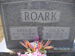
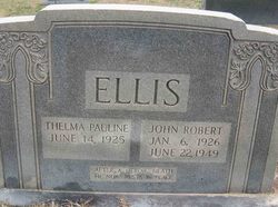
Thelma Pauline “Polly” Roark Ellis
| Birth | : | 14 Jun 1925 |
| Death | : | 28 Nov 2010 |
| Burial | : | Mount Vernon Cemetery, Miles Crossroads, Clay County, USA |
| Coordinate | : | 36.5435982, -85.7403030 |
| Description | : | Thelma Pauline Ellis (Roark) "Polly" Date of Death Sunday November 28th 2010 Place of Death Upstate Carolina Medicial Center Gordon Mortuary 400 West Cherokee Street Blacksburg, SC Service Information When Wednesday December 1st 2010 4:00pm Obituary for Thelma Ellis Gaffney -- Thelma Pauline (Polly) Roark Ellis, 85, of 1434 N. Limestone St., but formerly of 190 Roark Road in Blacksburg, passed away Sunday, November 28th, 2010 at Upstate Carolina Medicial Center. Born in Gaffney, Mrs. Ellis was the widow of John Robert Ellis and the daughter of the late John Sullivan and Lula Rachel Moss Roark. She retired as a record clerk for the... Read More |
frequently asked questions (FAQ):
-
Where is Thelma Pauline “Polly” Roark Ellis's memorial?
Thelma Pauline “Polly” Roark Ellis's memorial is located at: Mount Vernon Cemetery, Miles Crossroads, Clay County, USA.
-
When did Thelma Pauline “Polly” Roark Ellis death?
Thelma Pauline “Polly” Roark Ellis death on 28 Nov 2010 in
-
Where are the coordinates of the Thelma Pauline “Polly” Roark Ellis's memorial?
Latitude: 36.5435982
Longitude: -85.7403030
Family Members:
Parent

Spouse
Children
Flowers:


Nearby Cemetories:
1. Mount Vernon Cemetery
Miles Crossroads, Clay County, USA
Coordinate: 36.5435982, -85.7403030
2. James H. Cherry Family Cemetery
Clay County, USA
Coordinate: 36.5453700, -85.7266000
3. Browning Cemetery
Clay County, USA
Coordinate: 36.5578003, -85.7602997
4. Cherry Denton Cemetery
Clay County, USA
Coordinate: 36.5512200, -85.6971200
5. Edna Lee Biblery
Bakerton, Clay County, USA
Coordinate: 36.5048730, -85.7420270
6. Leonard Cemetery
Clay County, USA
Coordinate: 36.5250015, -85.7863998
7. Jonestown Cemetery
Clay County, USA
Coordinate: 36.5619011, -85.6921997
8. Hinson Cemetery
Moss, Clay County, USA
Coordinate: 36.5756750, -85.7020010
9. Hermitage Springs Cemetery
Hermitage Springs, Clay County, USA
Coordinate: 36.5823500, -85.7750900
10. Pedigo Cemetery
Clay County, USA
Coordinate: 36.5744019, -85.7863998
11. Pricetown Cemetery
Clay County, USA
Coordinate: 36.5422500, -85.6750670
12. Reeves Cemetery
Hermitage Springs, Clay County, USA
Coordinate: 36.5760994, -85.7977982
13. Griffith Family Cemetery
Gainesboro, Jackson County, USA
Coordinate: 36.4896790, -85.7759830
14. Franklin-York Cemetery
Clay County, USA
Coordinate: 36.5141190, -85.8079140
15. Cherry Cemetery #3
Oak Grove, Clay County, USA
Coordinate: 36.6015000, -85.7100300
16. Pitcock Cemetery
Clay County, USA
Coordinate: 36.5992012, -85.6911011
17. Cherry Family Cemetery #02
Clay County, USA
Coordinate: 36.5071260, -85.6685290
18. Clementsville Cemetery
Clementsville, Clay County, USA
Coordinate: 36.6132300, -85.7146410
19. Smith Cemetery
Pine Hill, Clay County, USA
Coordinate: 36.5714930, -85.6568170
20. Biles Cemetery
Hermitage Springs, Clay County, USA
Coordinate: 36.6039009, -85.7919006
21. Eads-Denton Cemetery
Pine Hill, Clay County, USA
Coordinate: 36.5644207, -85.6503187
22. Hix Family Cemetery
Jackson County, USA
Coordinate: 36.4842240, -85.6821690
23. Cunningham Family Cemetery
Jackson County, USA
Coordinate: 36.4652778, -85.7427778
24. Chimney Rock Cemetery
Hermitage Springs, Clay County, USA
Coordinate: 36.6138200, -85.7849000