
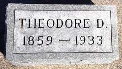
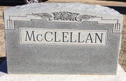
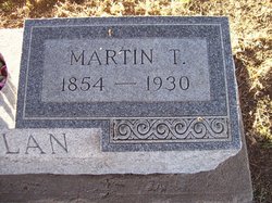
Theodore Davison “T. D.” McClellan
| Birth | : | 1 Sep 1859 Winterset, Madison County, Iowa, USA |
| Death | : | 14 Dec 1933 Glasco, Cloud County, Kansas, USA |
| Burial | : | Wolvercote Cemetery, Oxford, City of Oxford, England |
| Coordinate | : | 51.7913666, -1.2721500 |
| Plot | : | 7GE2 |
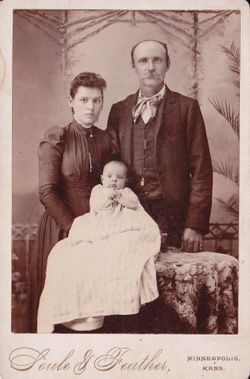
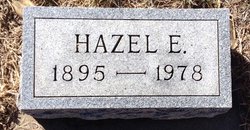
| Description | : | Glasco Sun, Dec. 21, 1933, page 1: Theodore Davison McClellan, the last of a family of eleven, was born near Winterset, Iowa September 1, 1859. He passed away at his home in Glasco, December 14, 1933. He came to Kansas, March 1872, and lived on his farm for 52 years. When his health began to fail, he moved to Glasco. He was married to Margaret Humble January 1, 1891. To this union were born one son and three daughters. The son died in infancy. Besides the widow, there remain three daughters; Mrs. Mary Elliott, Hazel and... Read More |
frequently asked questions (FAQ):
-
Where is Theodore Davison “T. D.” McClellan's memorial?
Theodore Davison “T. D.” McClellan's memorial is located at: Wolvercote Cemetery, Oxford, City of Oxford, England.
-
When did Theodore Davison “T. D.” McClellan death?
Theodore Davison “T. D.” McClellan death on 14 Dec 1933 in Glasco, Cloud County, Kansas, USA
-
Where are the coordinates of the Theodore Davison “T. D.” McClellan's memorial?
Latitude: 51.7913666
Longitude: -1.2721500
Family Members:
Parent
Spouse
Siblings
Children
Flowers:


Nearby Cemetories:
1. Wolvercote Cemetery
Oxford, City of Oxford, England
Coordinate: 51.7913666, -1.2721500
2. St. Peter Churchyard
Wolvercote, City of Oxford, England
Coordinate: 51.7848300, -1.2811100
3. St Michael and All Angels Summertown
Oxford, City of Oxford, England
Coordinate: 51.7796280, -1.2643940
4. Godstow Abbey Ruins
Oxford, City of Oxford, England
Coordinate: 51.7784060, -1.2998170
5. St. Bartholomew's Churchyard
Yarnton, Cherwell District, England
Coordinate: 51.8016610, -1.3087620
6. Yarnton Cemetery
Yarnton, Cherwell District, England
Coordinate: 51.8004080, -1.3103260
7. St. Nicholas Churchyard
Old Marston, City of Oxford, England
Coordinate: 51.7761340, -1.2373130
8. Saint Margaret of Antioch
City of Oxford, England
Coordinate: 51.7690340, -1.2975900
9. Elsfield Road Cemetery
Old Marston, City of Oxford, England
Coordinate: 51.7752940, -1.2332640
10. St. Sepulchres Cemetery
Oxford, City of Oxford, England
Coordinate: 51.7611110, -1.2694440
11. Wytham Churchyard
Wytham, Vale of White Horse District, England
Coordinate: 51.7736230, -1.3131610
12. Woodeaton Holy Rood Churchyard
Woodeaton, South Oxfordshire District, England
Coordinate: 51.8031620, -1.2257910
13. St Paul's Oxford Cemetery
Oxford, City of Oxford, England
Coordinate: 51.7594590, -1.2648470
14. St Giles Churchyard
Oxford, City of Oxford, England
Coordinate: 51.7591660, -1.2605170
15. Saint Barnabas Church
Oxford, City of Oxford, England
Coordinate: 51.7579620, -1.2697600
16. St Thomas of Canterbury Churchyard
Elsfield, South Oxfordshire District, England
Coordinate: 51.7858680, -1.2178310
17. Mansfield College Chapel
Oxford, City of Oxford, England
Coordinate: 51.7576410, -1.2523340
18. Blackfriars
Oxford, City of Oxford, England
Coordinate: 51.7561210, -1.2602060
19. St Johns College
Oxford, City of Oxford, England
Coordinate: 51.7560820, -1.2589910
20. Wadham College Chapel
Oxford, City of Oxford, England
Coordinate: 51.7560700, -1.2540350
21. Rewley Abbey
Oxford, City of Oxford, England
Coordinate: 51.7543810, -1.2675170
22. Martyrs' Memorial
Oxford, City of Oxford, England
Coordinate: 51.7550900, -1.2590100
23. Kidlington Burial Ground
Kidlington, Cherwell District, England
Coordinate: 51.8266010, -1.2916660
24. Trinity College Chapel
Oxford, City of Oxford, England
Coordinate: 51.7552360, -1.2569620