
| Birth | : | 29 Sep 1880 Floyd County, Virginia, USA |
| Death | : | 17 Feb 1962 Roanoke City, Virginia, USA |
| Burial | : | St. Leonard's Churchyard, Watlington, South Oxfordshire District, England |
| Coordinate | : | 51.6474030, -1.0117420 |
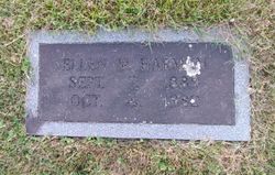
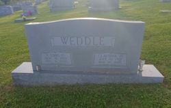
| Inscription | : | WEDDLE // Thomas T. / Sept. 29, 1880 / Feb. 17, 1962 // Loula A. / June 29, 1889 / Oct. 26, 1971 |
frequently asked questions (FAQ):
-
Where is Thomas Tazewell “Tom” Weddle's memorial?
Thomas Tazewell “Tom” Weddle's memorial is located at: St. Leonard's Churchyard, Watlington, South Oxfordshire District, England.
-
When did Thomas Tazewell “Tom” Weddle death?
Thomas Tazewell “Tom” Weddle death on 17 Feb 1962 in Roanoke City, Virginia, USA
-
Where are the coordinates of the Thomas Tazewell “Tom” Weddle's memorial?
Latitude: 51.6474030
Longitude: -1.0117420
Family Members:
Parent
Spouse

Siblings
Children
Flowers:


Nearby Cemetories:
1. St. Leonard's Churchyard
Watlington, South Oxfordshire District, England
Coordinate: 51.6474030, -1.0117420
2. Watlington War Memorial
Watlington, South Oxfordshire District, England
Coordinate: 51.6456450, -1.0065781
3. St Mary Churchyard
Pyrton, South Oxfordshire District, England
Coordinate: 51.6558520, -1.0076830
4. St Nicholas Churchyard
Britwell Salome, South Oxfordshire District, England
Coordinate: 51.6376983, -1.0262075
5. All Saints Churchyard
Shirburn, South Oxfordshire District, England
Coordinate: 51.6577000, -0.9945000
6. Holy Rood Churchyard
Cuxham, South Oxfordshire District, England
Coordinate: 51.6516250, -1.0376070
7. Brightwell Baldwin St Bartholomews Churchyard
Brightwell Baldwin, South Oxfordshire District, England
Coordinate: 51.6500670, -1.0569610
8. St Peter Churchyard
Easington, South Oxfordshire District, England
Coordinate: 51.6684300, -1.0443070
9. St Margarets Churchyard
Lewknor, South Oxfordshire District, England
Coordinate: 51.6730340, -0.9663030
10. St. Mary Magdalene
Stoke Talmage, South Oxfordshire District, England
Coordinate: 51.6878240, -1.0183240
11. St. Andrew's Churchyard
Wheatfield, South Oxfordshire District, England
Coordinate: 51.6879720, -1.0050930
12. St. Botolph Old Cemetery
Swyncombe, South Oxfordshire District, England
Coordinate: 51.6065347, -1.0157358
13. St. Botolph's New Graveyard
Swyncombe, South Oxfordshire District, England
Coordinate: 51.6064829, -1.0167999
14. St. Mary's Churchyard
Adwell, South Oxfordshire District, England
Coordinate: 51.6906560, -0.9938380
15. St. Mary the Virgin Churchyard
Ewelme, South Oxfordshire District, England
Coordinate: 51.6177310, -1.0674850
16. St Mary's Church Cemetery
Chalgrove, South Oxfordshire District, England
Coordinate: 51.6641000, -1.0802000
17. Getty Family Estate
Stokenchurch, Wycombe District, England
Coordinate: 51.6437360, -0.9334510
18. St. Peter and St. Paul's Church Cemetery
Aston Rowant, South Oxfordshire District, England
Coordinate: 51.6851100, -0.9502900
19. Pishill Parish Church Cemetery
Pishill, South Oxfordshire District, England
Coordinate: 51.6027550, -0.9527530
20. St Giles Churchyard
Tetsworth, South Oxfordshire District, England
Coordinate: 51.7085800, -1.0086700
21. Benson War Memorial
Benson, South Oxfordshire District, England
Coordinate: 51.6207890, -1.1108700
22. St Nicholas Churchyard
Ibstone, Wycombe District, England
Coordinate: 51.6247660, -0.9093120
23. St. Helen Churchyard Extension
Benson, South Oxfordshire District, England
Coordinate: 51.6201400, -1.1121200
24. Holy Trinity Churchyard
Nuffield, South Oxfordshire District, England
Coordinate: 51.5810040, -1.0378960