
| Memorials | : | 5 |
| Location | : | Stoke Talmage, South Oxfordshire District, England |
| Website | : | www.achurchnearyou.com/stoke-talmage-st-mary-magdalen/ |
| Coordinate | : | 51.6878240, -1.0183240 |
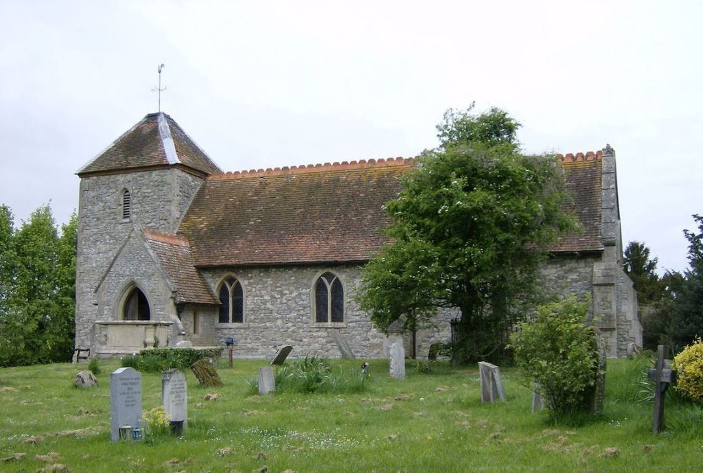
| Description | : | Stoke Talmage seems to have had a parish church since the 11th century, although the first clear historical reference to it dates from 1219. The Church of England parish church of Saint Mary Magdalene was restored in 1758. In 1860 it was restored again and extended to plans by George Gilbert Scott. St. Mary Magdalene Rectory was built in 1752. It was extended in 1820 by the builder and architect Daniel Harris. |
frequently asked questions (FAQ):
-
Where is St. Mary Magdalene?
St. Mary Magdalene is located at Stoke Talmage, Oxfordshire,- In the centre of the village Stoke Talmage, South Oxfordshire District ,Oxfordshire , OX9 7EVEngland.
-
St. Mary Magdalene cemetery's updated grave count on graveviews.com?
5 memorials
-
Where are the coordinates of the St. Mary Magdalene?
Latitude: 51.6878240
Longitude: -1.0183240
Nearby Cemetories:
1. St. Andrew's Churchyard
Wheatfield, South Oxfordshire District, England
Coordinate: 51.6879720, -1.0050930
2. St. Mary's Churchyard
Adwell, South Oxfordshire District, England
Coordinate: 51.6906560, -0.9938380
3. St Giles Churchyard
Tetsworth, South Oxfordshire District, England
Coordinate: 51.7085800, -1.0086700
4. St Peter Churchyard
Easington, South Oxfordshire District, England
Coordinate: 51.6684300, -1.0443070
5. St Mary Churchyard
Pyrton, South Oxfordshire District, England
Coordinate: 51.6558520, -1.0076830
6. All Saints Churchyard
Shirburn, South Oxfordshire District, England
Coordinate: 51.6577000, -0.9945000
7. St Margarets Churchyard
Lewknor, South Oxfordshire District, England
Coordinate: 51.6730340, -0.9663030
8. Holy Rood Churchyard
Cuxham, South Oxfordshire District, England
Coordinate: 51.6516250, -1.0376070
9. St Peter Churchyard
Great Haseley, South Oxfordshire District, England
Coordinate: 51.7102600, -1.0693200
10. St. Leonard's Churchyard
Watlington, South Oxfordshire District, England
Coordinate: 51.6474030, -1.0117420
11. St. Peter and St. Paul's Church Cemetery
Aston Rowant, South Oxfordshire District, England
Coordinate: 51.6851100, -0.9502900
12. Watlington War Memorial
Watlington, South Oxfordshire District, England
Coordinate: 51.6456450, -1.0065781
13. Brightwell Baldwin St Bartholomews Churchyard
Brightwell Baldwin, South Oxfordshire District, England
Coordinate: 51.6500670, -1.0569610
14. St Mary's Church Cemetery
Chalgrove, South Oxfordshire District, England
Coordinate: 51.6641000, -1.0802000
15. Rycote Chapel
Great Haseley, South Oxfordshire District, England
Coordinate: 51.7366100, -1.0355370
16. St Nicholas Churchyard
Britwell Salome, South Oxfordshire District, England
Coordinate: 51.6376983, -1.0262075
17. Thame Park Chapel
Thame, South Oxfordshire District, England
Coordinate: 51.7290130, -0.9650540
18. St Mary's Churchyard
Sydenham, South Oxfordshire District, England
Coordinate: 51.7112360, -0.9398460
19. St Mary the Virgin Churchyard
Great Milton, South Oxfordshire District, England
Coordinate: 51.7170320, -1.0921100
20. North Weston Chapel
Thame, South Oxfordshire District, England
Coordinate: 51.7433420, -1.0153490
21. St Helen Churchyard
Albury, South Oxfordshire District, England
Coordinate: 51.7406280, -1.0519520
22. Nativity of the Blessed Virgin Mary Churchyard
Crowell, South Oxfordshire District, England
Coordinate: 51.6921610, -0.9268631
23. St James Churchyard
Little Milton, South Oxfordshire District, England
Coordinate: 51.7019280, -1.1072800
24. Thame War Memorial
Thame, South Oxfordshire District, England
Coordinate: 51.7452570, -0.9743330