

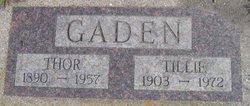
Thor Gaden
| Birth | : | 11 Mar 1890 Trondheim kommune, Sør-Trøndelag fylke, Norway |
| Death | : | 13 Nov 1957 Jessie, Griggs County, North Dakota, USA |
| Burial | : | Saint John the Baptist Churchyard, North Cheriton, South Somerset District, England |
| Coordinate | : | 51.0309000, -2.4474000 |
| Description | : | Thor Gaden, 68, died November 13 in Jessie. The funeral was held Saturday in Naroen church at Mose, the Rev. A. O. Borlaug officiating. Mr. Gaden was born March 11, 1890, in Trondheim, Norway, the son of Fredrick and Joanna Gaden. He came to the United States in 1909, coming first to Cooperstown. In 1914 he went to Mose. He married Tillie Johnson in Cooperstown November 6, 1924. They farmed near Mose until 1941, when they moved to Jessie. Survivors, besides Mrs. Gaden, include two sons, Ervin, in Minneapolis with the Air Force, and Kenneth, Jessie, and... Read More |
frequently asked questions (FAQ):
-
Where is Thor Gaden's memorial?
Thor Gaden's memorial is located at: Saint John the Baptist Churchyard, North Cheriton, South Somerset District, England.
-
When did Thor Gaden death?
Thor Gaden death on 13 Nov 1957 in Jessie, Griggs County, North Dakota, USA
-
Where are the coordinates of the Thor Gaden's memorial?
Latitude: 51.0309000
Longitude: -2.4474000
Family Members:
Spouse
Children


Flowers:


Nearby Cemetories:
1. Saint John the Baptist Churchyard
North Cheriton, South Somerset District, England
Coordinate: 51.0309000, -2.4474000
2. North Cheriton Cemetery
North Cheriton, South Somerset District, England
Coordinate: 51.0284840, -2.4389150
3. Saint Nicholas Churchyard
Holton, South Somerset District, England
Coordinate: 51.0401280, -2.4502641
4. St. Peter & St. Paul Churchyard
Maperton, South Somerset District, England
Coordinate: 51.0335993, -2.4686628
5. Saint John's Churchyard
Horsington, South Somerset District, England
Coordinate: 51.0126300, -2.4238400
6. St. Michael's Churchyard
Blackford, South Somerset District, England
Coordinate: 51.0336960, -2.4892290
7. Saint Peter & Saint Paul Churchyard
Charlton Horethorne, South Somerset District, England
Coordinate: 51.0060200, -2.4790100
8. St. Nicholas' Churchyard
Bratton Seymour, South Somerset District, England
Coordinate: 51.0679406, -2.4625400
9. Blessed Virgin Mary Churchyard
Compton Pauncefoot, South Somerset District, England
Coordinate: 51.0336770, -2.5089430
10. Saint Stephen Churchyard
Charlton Musgrove, South Somerset District, England
Coordinate: 51.0678630, -2.4008550
11. St Michael Churchyard
North Cadbury, South Somerset District, England
Coordinate: 51.0416670, -2.5213610
12. Corton Denham Cemetery
Corton Denham, South Somerset District, England
Coordinate: 51.0015810, -2.5202380
13. Saint Andrew Churchyard
Corton Denham, South Somerset District, England
Coordinate: 51.0015790, -2.5203100
14. All Saints Churchyard
Poyntington, West Dorset District, England
Coordinate: 50.9782070, -2.4997530
15. Civic Cemetery
Buckhorn Weston, North Dorset District, England
Coordinate: 51.0212440, -2.3484600
16. St Leonard Churchyard and Extension
Pitcombe, South Somerset District, England
Coordinate: 51.0925600, -2.4684600
17. St John The Baptist Churchyard
Buckhorn Weston, North Dorset District, England
Coordinate: 51.0212870, -2.3481780
18. St Lawrence Churchyard
Cucklington, South Somerset District, England
Coordinate: 51.0487190, -2.3507950
19. St Nicholas Churchyard
Henstridge, South Somerset District, England
Coordinate: 50.9762610, -2.3957980
20. Milborne Port Cemetery
Milborne Port, South Somerset District, England
Coordinate: 50.9662940, -2.4605880
21. Saint John's Churchyard
Charlton Musgrove, South Somerset District, England
Coordinate: 51.0840723, -2.3869787
22. Milborne Port Churchyard
Milborne Port, South Somerset District, England
Coordinate: 50.9653900, -2.4621550
23. St Peter Churchyard
Redlynch, South Somerset District, England
Coordinate: 51.0983279, -2.4299457
24. Castle Cary Cemetery
Castle Cary, South Somerset District, England
Coordinate: 51.0803800, -2.5223600