

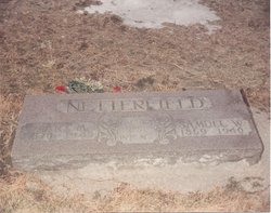
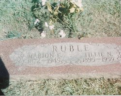
Tillie Leroy Netterfield Ruble
| Birth | : | 6 Aug 1895 Cambridge, Story County, Iowa, USA |
| Death | : | 16 Aug 1959 Des Moines, Polk County, Iowa, USA |
| Burial | : | Saint John the Baptist, Stanton St John, South Oxfordshire District, England |
| Coordinate | : | 51.7800350, -1.1642830 |
| Plot | : | South Section, Row 17, Grave 1 |
| Description | : | Tillie is a daughter of Samuel Warren Netterfield and Mary Margaret ("Maggie") (McCollister), and the wife first of Bernie Brown, second of Sherm Smithart, and third of Marion "Elmer" Ruble. |
frequently asked questions (FAQ):
-
Where is Tillie Leroy Netterfield Ruble's memorial?
Tillie Leroy Netterfield Ruble's memorial is located at: Saint John the Baptist, Stanton St John, South Oxfordshire District, England.
-
When did Tillie Leroy Netterfield Ruble death?
Tillie Leroy Netterfield Ruble death on 16 Aug 1959 in Des Moines, Polk County, Iowa, USA
-
Where are the coordinates of the Tillie Leroy Netterfield Ruble's memorial?
Latitude: 51.7800350
Longitude: -1.1642830
Family Members:
Parent

Spouse
Siblings
Children

Flowers:


Nearby Cemetories:
1. Saint John the Baptist
Stanton St John, South Oxfordshire District, England
Coordinate: 51.7800350, -1.1642830
2. Forest Hill Church Cemetery
Forest Hill, South Oxfordshire District, England
Coordinate: 51.7641700, -1.1567100
3. St. Nicholas' Church
Forest Hill, South Oxfordshire District, England
Coordinate: 51.7641400, -1.1567200
4. Oxford Crematorium
Headington, City of Oxford, England
Coordinate: 51.7719240, -1.1904020
5. Assumption of the Blessed Virgin Mary Churchyard
Beckley, South Oxfordshire District, England
Coordinate: 51.7972530, -1.1858920
6. Cornerstone Church Cemetery
Headington, City of Oxford, England
Coordinate: 51.7587275, -1.1995588
7. Holy Trinity Churchyard
Headington, City of Oxford, England
Coordinate: 51.7577500, -1.1979980
8. St Barnabas Churchyard
Horton-cum-Studley, Cherwell District, England
Coordinate: 51.8077260, -1.1409690
9. Studley Priory
Horton-cum-Studley, Cherwell District, England
Coordinate: 51.8054560, -1.1346920
10. The Priory
Headington, City of Oxford, England
Coordinate: 51.7638260, -1.2108100
11. St Andrew Churchyard
Headington, City of Oxford, England
Coordinate: 51.7647100, -1.2121400
12. St Thomas of Canterbury Churchyard
Elsfield, South Oxfordshire District, England
Coordinate: 51.7858680, -1.2178310
13. Headington Cemetery
Headington, City of Oxford, England
Coordinate: 51.7668050, -1.2179280
14. St Bartholomew Churchyard
Holton, South Oxfordshire District, England
Coordinate: 51.7529490, -1.1246510
15. St Mary the Virgin Churchyard
Wheatley, South Oxfordshire District, England
Coordinate: 51.7476020, -1.1366080
16. Wheatley War Memorial
Wheatley, South Oxfordshire District, England
Coordinate: 51.7468630, -1.1388780
17. St. Giles' Churchyard
Horspath, South Oxfordshire District, England
Coordinate: 51.7397190, -1.1738770
18. St. Aldate's Churchyard
Oxford, City of Oxford, England
Coordinate: 51.7497900, -1.2118500
19. Elsfield Road Cemetery
Old Marston, City of Oxford, England
Coordinate: 51.7752940, -1.2332640
20. Woodeaton Holy Rood Churchyard
Woodeaton, South Oxfordshire District, England
Coordinate: 51.8031620, -1.2257910
21. St Giles Churchyard
Noke, Cherwell District, England
Coordinate: 51.8145050, -1.2114790
22. St. Nicholas Churchyard
Old Marston, City of Oxford, England
Coordinate: 51.7761340, -1.2373130
23. St. Clements Churchyard
Oxford, City of Oxford, England
Coordinate: 51.7527790, -1.2369920
24. St. Andrew Churchyard
Oddington, Cherwell District, England
Coordinate: 51.8291010, -1.1996230