
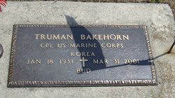
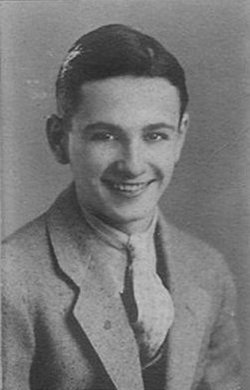
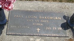
Truman “Bud” Bakehorn
| Birth | : | 18 Jan 1931 Wabash, Wabash County, Indiana, USA |
| Death | : | 31 Mar 2001 Wabash, Wabash County, Indiana, USA |
| Burial | : | Saint Mary the Virgin Churchyard, Uttoxeter, East Staffordshire Borough, England |
| Coordinate | : | 52.8987700, -1.8624100 |
| Inscription | : | CPL US Marine Korea |
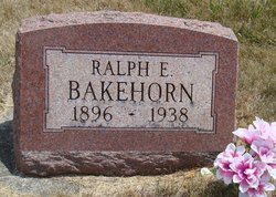
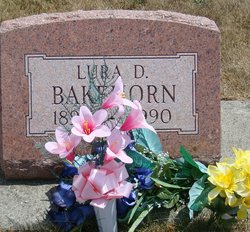
| Description | : | Truman was the son of Ralph and Lura (Kistler) Bakehorn. |
frequently asked questions (FAQ):
-
Where is Truman “Bud” Bakehorn's memorial?
Truman “Bud” Bakehorn's memorial is located at: Saint Mary the Virgin Churchyard, Uttoxeter, East Staffordshire Borough, England.
-
When did Truman “Bud” Bakehorn death?
Truman “Bud” Bakehorn death on 31 Mar 2001 in Wabash, Wabash County, Indiana, USA
-
Where are the coordinates of the Truman “Bud” Bakehorn's memorial?
Latitude: 52.8987700
Longitude: -1.8624100
Family Members:
Parent
Siblings


Nearby Cemetories:
1. Saint Mary the Virgin Churchyard
Uttoxeter, East Staffordshire Borough, England
Coordinate: 52.8987700, -1.8624100
2. St. Cuthbert's Churchyard
Doveridge, Derbyshire Dales District, England
Coordinate: 52.9042368, -1.8317361
3. St Michael and All Angels Churchyard
Stramshall, East Staffordshire Borough, England
Coordinate: 52.9201040, -1.8836100
4. St Lawrence Churchyard
Bramshall, East Staffordshire Borough, England
Coordinate: 52.8963900, -1.9106400
5. Dove Evangelical Free Church, Somersal Herbert
Doveridge, Derbyshire Dales District, England
Coordinate: 52.9109200, -1.7905560
6. St. John the Baptist Churchyard
Kingstone, East Staffordshire Borough, England
Coordinate: 52.8630944, -1.9115108
7. St Peter's Churchyard
Marchington, East Staffordshire Borough, England
Coordinate: 52.8738278, -1.7967917
8. St. Giles Churchyard
Marston Montgomery, Derbyshire Dales District, England
Coordinate: 52.9382120, -1.8007610
9. All Saints Churchyard
Sudbury, Derbyshire Dales District, England
Coordinate: 52.8867660, -1.7667510
10. Croxden Abbey
Croxden, East Staffordshire Borough, England
Coordinate: 52.9549890, -1.9042630
11. All Saints Churchyard
Leigh, East Staffordshire Borough, England
Coordinate: 52.9199520, -1.9657840
12. St. Mary and All Saints Churchyard
Checkley, Staffordshire Moorlands District, England
Coordinate: 52.9384190, -1.9598100
13. St Leonard Churchyard
Bradley in the Moors, Staffordshire Moorlands District, England
Coordinate: 52.9693440, -1.9135150
14. St. Nicholas Churchyard
Abbots Bromley, East Staffordshire Borough, England
Coordinate: 52.8184560, -1.8837460
15. St John Churchyard
Alton, Staffordshire Moorlands District, England
Coordinate: 52.9783380, -1.8919190
16. St. Peter's Churchyard
Alton, Staffordshire Moorlands District, England
Coordinate: 52.9783470, -1.8918600
17. St. John the Baptist Churchyard
Boylestone, Derbyshire Dales District, England
Coordinate: 52.9195410, -1.7313190
18. All Saints Churchyard
Newborough, East Staffordshire Borough, England
Coordinate: 52.8259013, -1.8003185
19. St. Mary and St. Barlock Churchyard
Norbury, Derbyshire Dales District, England
Coordinate: 52.9787350, -1.8146430
20. St Werburgh's Church
Hanbury, East Staffordshire Borough, England
Coordinate: 52.8485000, -1.7478000
21. Christ Church Churchyard
Upper Tean, Staffordshire Moorlands District, England
Coordinate: 52.9529687, -1.9831798
22. Saint Peter's Cemetery
Ellastone, East Staffordshire Borough, England
Coordinate: 52.9882900, -1.8275000
23. RAF Fauld
Hanbury, East Staffordshire Borough, England
Coordinate: 52.8474200, -1.7303500
24. St. Paul's Churchyard Extension
Scropton, South Derbyshire District, England
Coordinate: 52.8687230, -1.7133750