

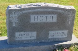
Viola Marie Schloetzer Hoth
| Birth | : | 4 Jul 1905 Garnavillo, Clayton County, Iowa, USA |
| Death | : | 24 Apr 1978 Elkader, Clayton County, Iowa, USA |
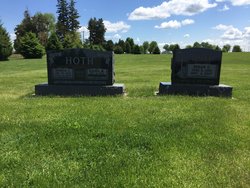
| Burial | : | Zion Lutheran Cemetery, Clayton Center, Clayton County, USA |
| Coordinate | : | 42.8841705, -91.3249969 |
| Description | : | Viola Marie Hoth Funeral service for Viola Marie (Schloetzer) Hoth were conducted by Rev. John Zerhusen Wed., April 26, 1978 at 11 a.m. at Zion Lutheran Church, Clayton Center, Ia. Viola died April 24, 1978 at Central Community Hospital, Elkader. A daughter of Wm. and Kathryn Schloetzer, she was born July 4, 1905 on a Garnavillo Township farm. She attended the rural school of her community. Viola was baptized Sept. 10, 1905 and confirmed April 13, 1919. On Sept. 25, 1923 she was married to Edwin Ernst Hoth in Dubuque, Ia. by Rev. J. Zelilinger. They celebrated their 50th wedding... Read More |
frequently asked questions (FAQ):
-
Where is Viola Marie Schloetzer Hoth's memorial?
Viola Marie Schloetzer Hoth's memorial is located at: Zion Lutheran Cemetery, Clayton Center, Clayton County, USA.
-
When did Viola Marie Schloetzer Hoth death?
Viola Marie Schloetzer Hoth death on 24 Apr 1978 in Elkader, Clayton County, Iowa, USA
-
Where are the coordinates of the Viola Marie Schloetzer Hoth's memorial?
Latitude: 42.8841705
Longitude: -91.3249969
Family Members:
Spouse
Children
Flowers:


Nearby Cemetories:
1. Zion Lutheran Cemetery
Clayton Center, Clayton County, USA
Coordinate: 42.8841705, -91.3249969
2. Clayton Center Cemetery
Clayton Center, Clayton County, USA
Coordinate: 42.8841705, -91.3225021
3. County Home Cemetery
Clayton Center, Clayton County, USA
Coordinate: 42.8916702, -91.3499985
4. Colony Catholic Cemetery (Defunct)
Read Township, Clayton County, USA
Coordinate: 42.8830000, -91.3580000
5. Saint Joseph Cemetery
Garnavillo, Clayton County, USA
Coordinate: 42.8628006, -91.2502975
6. Elkader Cemetery
Elkader, Clayton County, USA
Coordinate: 42.8541718, -91.4000015
7. Garnavillo Community Cemetery
Garnavillo, Clayton County, USA
Coordinate: 42.8656000, -91.2422100
8. Garnavillo Cemetery
Garnavillo, Clayton County, USA
Coordinate: 42.8660300, -91.2390100
9. Saint Josephs Cemetery
Elkader, Clayton County, USA
Coordinate: 42.8488998, -91.4021988
10. Farmersburg-Wagner Cemetery
Farmersburg, Clayton County, USA
Coordinate: 42.9481010, -91.3700027
11. National Cemetery
National, Clayton County, USA
Coordinate: 42.9536018, -91.2902985
12. Hartman Cemetery
Cox Creek Township, Clayton County, USA
Coordinate: 42.8155360, -91.3880840
13. Meenan Cemetery
Communia, Clayton County, USA
Coordinate: 42.7999862, -91.3584693
14. Norway Lutheran Church Cemetery
Saint Olaf, Clayton County, USA
Coordinate: 42.9352798, -91.4302826
15. Krumm Cemetery
Garber, Clayton County, USA
Coordinate: 42.7913760, -91.3023559
16. Bismark Cemetery
Farmersburg, Clayton County, USA
Coordinate: 42.9790000, -91.3500000
17. Patterson Pioneer Cemetery
Saint Olaf, Clayton County, USA
Coordinate: 42.9216000, -91.4489000
18. Communia Cemetery
Volga Township, Clayton County, USA
Coordinate: 42.7868996, -91.3630981
19. McClelland Cemetery
Garnavillo, Clayton County, USA
Coordinate: 42.8249879, -91.2084641
20. Weymouth Cemetery
Saint Olaf, Clayton County, USA
Coordinate: 42.9278799, -91.4583559
21. Giard Cemetery
Farmersburg, Clayton County, USA
Coordinate: 42.9933014, -91.3080978
22. Clark Family Cemetery
Beulah, Clayton County, USA
Coordinate: 42.9166505, -91.4751415
23. Wagner Township Cemetery
Saint Olaf, Clayton County, USA
Coordinate: 42.9519386, -91.4513931
24. Blanchaine Cemetery
Volga, Clayton County, USA
Coordinate: 42.7676210, -91.3389040