
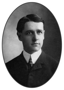
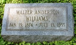
Walter Anderson Williams
| Birth | : | 19 Jan 1874 Maryland, USA |
| Death | : | 13 Jul 1955 Rockville, Montgomery County, Maryland, USA |
| Burial | : | Sunset View Cemetery, El Cerrito, Contra Costa County, USA |
| Coordinate | : | 37.9077721, -122.2871017 |
| Plot | : | Section A, Lot 9, Site 3 |
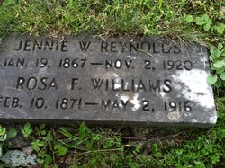
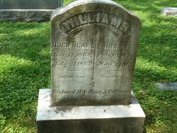
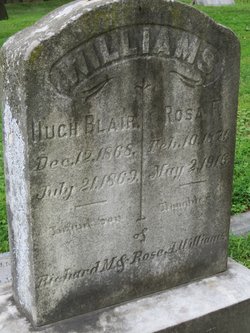
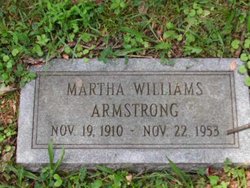
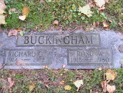
| Description | : | WILLIAMS, WALTER A. On Wednesday, July 13, 1955, at Montgomery County General Hospital, WALTER A. WILLIAMS of 10 Williams st., Rockville, Md., beloved husband of the late Barry Abert Williams, father of W. Anderson Williams, Mrs. Rose W. Buckingham, Mrs. Constance B. Allnutt and the late Martha S Armstrong. Friends are invited to call at the Colonial Funeral Home of Robert A. Pumphrey, Rockville, Md. Services Friday, July 15, at 2 p.m. at Christ Episcopal Church, Rockville, Md. Interment Rockville Union Cemetery. [The Washington Post, Times Herald, 15 Jul 1955: 36] |
frequently asked questions (FAQ):
-
Where is Walter Anderson Williams's memorial?
Walter Anderson Williams's memorial is located at: Sunset View Cemetery, El Cerrito, Contra Costa County, USA.
-
When did Walter Anderson Williams death?
Walter Anderson Williams death on 13 Jul 1955 in Rockville, Montgomery County, Maryland, USA
-
Where are the coordinates of the Walter Anderson Williams's memorial?
Latitude: 37.9077721
Longitude: -122.2871017
Family Members:
Parent

Spouse
Siblings
Children

Flowers:


Nearby Cemetories:
1. Sunset View Cemetery
El Cerrito, Contra Costa County, USA
Coordinate: 37.9077721, -122.2871017
2. Golden Gate Mausoleum and Columbaria
El Cerrito, Contra Costa County, USA
Coordinate: 37.9073150, -122.2857220
3. Northbrae Community Church Columbarium
Berkeley, Alameda County, USA
Coordinate: 37.8905500, -122.2763200
4. Golden Gate Fields
Albany, Alameda County, USA
Coordinate: 37.8854000, -122.3117000
5. Salesian Cemetery
Richmond, Contra Costa County, USA
Coordinate: 37.9532650, -122.3401230
6. Saint Joseph Catholic Cemetery
San Pablo, Contra Costa County, USA
Coordinate: 37.9612700, -122.3336600
7. Saint Pauls Cemetery (Defunct)
San Pablo, Contra Costa County, USA
Coordinate: 37.9563332, -122.3430099
8. Rolling Hills Memorial Park
Richmond, Contra Costa County, USA
Coordinate: 37.9756012, -122.3146973
9. Saint Mary's Cemetery
Oakland, Alameda County, USA
Coordinate: 37.8349991, -122.2418976
10. Home of Eternity Cemetery
Oakland, Alameda County, USA
Coordinate: 37.8322970, -122.2448270
11. Chapel of the Chimes Columbarium and Mausoleum
Oakland, Alameda County, USA
Coordinate: 37.8318863, -122.2456894
12. Chapel of Memories Columbarium
Oakland, Alameda County, USA
Coordinate: 37.8310471, -122.2480927
13. Gan Shalom Cemetery
Contra Costa County, USA
Coordinate: 37.9528122, -122.1975098
14. Mountain View Cemetery
Oakland, Alameda County, USA
Coordinate: 37.8327600, -122.2395200
15. Saint Stephens Episcopal Church Memorial Garden
Orinda, Contra Costa County, USA
Coordinate: 37.8982650, -122.1729170
16. Cathedral of Christ the Light Mausoleum
Oakland, Alameda County, USA
Coordinate: 37.8105316, -122.2633896
17. Lafayette-Orinda Presbyterian Church Garden
Contra Costa County, USA
Coordinate: 37.8866040, -122.1606950
18. Yerba Buena Island Cemetery (Defunct)
San Francisco, San Francisco County, USA
Coordinate: 37.8127420, -122.3707880
19. Saint Paul Lutheran Church
Oakland, Alameda County, USA
Coordinate: 37.8020820, -122.2222780
20. Angel Island Cemetery (defunct)
Tiburon, Marin County, USA
Coordinate: 37.8621830, -122.4325920
21. Home of Peace Cemetery
Oakland, Alameda County, USA
Coordinate: 37.7790604, -122.2036285
22. First Street Cemetery (Defunct)
San Francisco, San Francisco County, USA
Coordinate: 37.7906170, -122.3991770
23. Muir-Strentzel Hanna Cemetery
Martinez, Contra Costa County, USA
Coordinate: 37.9784393, -122.1232681
24. Bush Street Cemetery (Defunct)
San Francisco, San Francisco County, USA
Coordinate: 37.7907950, -122.4011960