
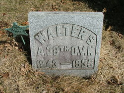


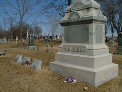
Walter Sperry Tomlinson
| Birth | : | 16 Jun 1843 Bryan, Williams County, Ohio, USA |
| Death | : | 6 Apr 1935 Farmer Township, Defiance County, Ohio, USA |
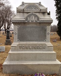
| Burial | : | Farmer Cemetery, Farmer, Defiance County, USA |
| Coordinate | : | 41.3903008, -84.6410980 |
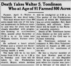
| Description | : | Walter was a breeder of Holstein Friesians and a farmer who owned a stock farm of 700 acres in Defiance County located 3/4 mile southeast of Williams Center (Williams Co. Ohio). Walter grew up at Williams Center and after he completed his education he became a teacher for a number of years. He served during the Civil War as a member of Co. A, 38th Ohio Volunteer Infantry, enlisting on August 26, 1861 and remaining in that unit until the close of the war. He was the former Commander of Lew Bowker Post No. 725, Grand Army of the Republic,... Read More |
frequently asked questions (FAQ):
-
Where is Walter Sperry Tomlinson's memorial?
Walter Sperry Tomlinson's memorial is located at: Farmer Cemetery, Farmer, Defiance County, USA.
-
When did Walter Sperry Tomlinson death?
Walter Sperry Tomlinson death on 6 Apr 1935 in Farmer Township, Defiance County, Ohio, USA
-
Where are the coordinates of the Walter Sperry Tomlinson's memorial?
Latitude: 41.3903008
Longitude: -84.6410980
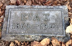
Family Members:
Parent

Spouse
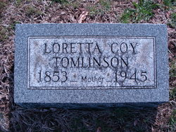
Children
Flowers:


Nearby Cemetories:
1. Farmer Cemetery
Farmer, Defiance County, USA
Coordinate: 41.3903008, -84.6410980
2. Upper Lost Creek Cemetery
Farmer, Defiance County, USA
Coordinate: 41.3840000, -84.6700000
3. Kemp Cemetery
Defiance County, USA
Coordinate: 41.3703003, -84.6802979
4. Lost Creek Cemetery
Farmer, Defiance County, USA
Coordinate: 41.3553000, -84.6700000
5. Williams Center Cemetery
Williams Center, Williams County, USA
Coordinate: 41.4288902, -84.6125031
6. Tamarack Cemetery
Milford Township, Defiance County, USA
Coordinate: 41.4117012, -84.7089005
7. Zion Lutheran Church Cemetery
Defiance County, USA
Coordinate: 41.4261017, -84.7099991
8. Fetters Cemetery
Williams County, USA
Coordinate: 41.4519500, -84.6159900
9. Melbern-Neihardt Cemetery
Melbern, Williams County, USA
Coordinate: 41.4633600, -84.6416330
10. Lintz Cemetery
Ney, Defiance County, USA
Coordinate: 41.3760986, -84.5402985
11. Trinity Lutheran Cemetery
Ney, Defiance County, USA
Coordinate: 41.4016991, -84.5353012
12. Yackee Cemetery
Williams County, USA
Coordinate: 41.4707985, -84.6324997
13. Ney Cemetery
Ney, Defiance County, USA
Coordinate: 41.3856010, -84.5271988
14. Six Corners Cemetery
Hicksville, Defiance County, USA
Coordinate: 41.3213997, -84.7153015
15. Saint Johns Lutheran Cemetery
Sherwood, Defiance County, USA
Coordinate: 41.3092003, -84.5931015
16. Doud Cemetery
Ney, Defiance County, USA
Coordinate: 41.3811680, -84.5161110
17. Fountain Grove Cemetery
Bryan, Williams County, USA
Coordinate: 41.4572182, -84.5480576
18. Thomas Cemetery
Williams County, USA
Coordinate: 41.4769100, -84.6994240
19. Brown Cemetery
Bryan, Williams County, USA
Coordinate: 41.4822006, -84.5935974
20. Maple Grove Cemetery
Edgerton, Williams County, USA
Coordinate: 41.4435997, -84.7521973
21. St. Mary's Cemetery
Edgerton, Williams County, USA
Coordinate: 41.4441120, -84.7542700
22. Clarksville Cemetery
Edgerton, Williams County, USA
Coordinate: 41.4281006, -84.7677994
23. Auglaize Village Cemetery
Defiance, Defiance County, USA
Coordinate: 41.3399760, -84.5165610
24. Funk Cemetery
Defiance County, USA
Coordinate: 41.3396988, -84.5164032