
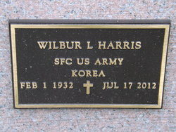
Wilbur Lee “Bill” Harris
| Birth | : | 1 Feb 1932 Ida Grove, Ida County, Iowa, USA |
| Death | : | 17 Jul 2012 Holton, Jackson County, Kansas, USA |
| Burial | : | General Cemetery, Nottingham, Nottingham Unitary Authority, England |
| Coordinate | : | 52.9561430, -1.1615420 |
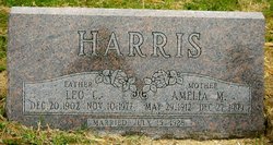
| Description | : | Wilbur Lee "Bill" Harris, 80, of Holton, KS passed July 17, 2012 at Medicalodge Jackson County in Holton. He was born February 1, 1932 in Ida Grove, Iowa the son of Leo C. and Amelia Martha (Wittmaack) Harris. Wilbur attended school in Ida Grove, IA and Powhattan. He served in the United States Army during the Korean Conflict from 1950 – 1953. He was a carpenter most of his life and was owner and operator of W.L. Harris Construction working out of Topeka and Mayetta. Wilbur attended the Larkinburg Christian Church. He was a life member of the... Read More |
frequently asked questions (FAQ):
-
Where is Wilbur Lee “Bill” Harris's memorial?
Wilbur Lee “Bill” Harris's memorial is located at: General Cemetery, Nottingham, Nottingham Unitary Authority, England.
-
When did Wilbur Lee “Bill” Harris death?
Wilbur Lee “Bill” Harris death on 17 Jul 2012 in Holton, Jackson County, Kansas, USA
-
Where are the coordinates of the Wilbur Lee “Bill” Harris's memorial?
Latitude: 52.9561430
Longitude: -1.1615420
Family Members:
Parent

Spouse
Siblings


Children
Flowers:


Nearby Cemetories:
1. General Cemetery
Nottingham, Nottingham Unitary Authority, England
Coordinate: 52.9561430, -1.1615420
2. Nottingham General Cemetery
Nottingham, Nottingham Unitary Authority, England
Coordinate: 52.9575370, -1.1594236
3. Cathedral Church of St. Barnabas
Nottingham, Nottingham Unitary Authority, England
Coordinate: 52.9546750, -1.1570460
4. Hardy Street Jewish Cemetery
Nottingham, Nottingham Unitary Authority, England
Coordinate: 52.9619500, -1.1665900
5. St Nicholas Churchyard
Nottingham, Nottingham Unitary Authority, England
Coordinate: 52.9504780, -1.1509220
6. St Peters Church Yard
Nottingham, Nottingham Unitary Authority, England
Coordinate: 52.9522800, -1.1486940
7. Nottingham Church Cemetery
Nottingham, Nottingham Unitary Authority, England
Coordinate: 52.9649830, -1.1558070
8. Holy Trinity Churchyard
Lenton, Nottingham Unitary Authority, England
Coordinate: 52.9485630, -1.1753148
9. St. Peter Churchyard Old Radford
Nottingham, Nottingham Unitary Authority, England
Coordinate: 52.9601830, -1.1789620
10. National Justice Museum High Pavement Nottingham
Nottingham Unitary Authority, England
Coordinate: 52.9510680, -1.1443050
11. St Mary's Burial Grounds
Nottingham, Nottingham Unitary Authority, England
Coordinate: 52.9527860, -1.1419160
12. St. Mary Rest Ground
Nottingham, Nottingham Unitary Authority, England
Coordinate: 52.9568310, -1.1406580
13. National Ice Centre
Nottingham, Nottingham Unitary Authority, England
Coordinate: 52.9527790, -1.1394460
14. St. John's Carrington Churchyard
Nottingham, Nottingham Unitary Authority, England
Coordinate: 52.9755350, -1.1506790
15. St. Wilfrid Churchyard
Wilford, Nottingham Unitary Authority, England
Coordinate: 52.9346290, -1.1587770
16. Wilford Village Cemetery
Wilford, Nottingham Unitary Authority, England
Coordinate: 52.9338540, -1.1591170
17. Basford Cemetery
Old Basford, Nottingham Unitary Authority, England
Coordinate: 52.9799700, -1.1725900
18. St. Leodegarius Churchyard
Old Basford, Nottingham Unitary Authority, England
Coordinate: 52.9794240, -1.1778650
19. St. Paul's Churchyard
Nottingham Unitary Authority, England
Coordinate: 52.9667590, -1.1172140
20. St. Giles's Church & Churchyard
West Bridgford, Rushcliffe Borough, England
Coordinate: 52.9316460, -1.1288450
21. St. Leonard's Churchyard
Wollaton, Nottingham Unitary Authority, England
Coordinate: 52.9529790, -1.2200830
22. Wollaton Cemetery
Wollaton, Nottingham Unitary Authority, England
Coordinate: 52.9503000, -1.2260800
23. Beeston Baptist Chapel
Beeston, Broxtowe Borough, England
Coordinate: 52.9246600, -1.2122000
24. Carlton Cemetery
Nottingham, Nottingham Unitary Authority, England
Coordinate: 52.9682820, -1.0900230