
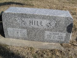
| Birth | : | 9 Nov 1881 Edgar, Clay County, Nebraska, USA |
| Death | : | 17 Mar 1969 Wymore, Gage County, Nebraska, USA |
| Burial | : | Street Cemetery, Street, Mendip District, England |
| Coordinate | : | 51.1302840, -2.7508240 |
| Plot | : | Block 16, Lot 11, Grave 4.5, Row 7 |
frequently asked questions (FAQ):
-
Where is William Arthur Wildt's memorial?
William Arthur Wildt's memorial is located at: Street Cemetery, Street, Mendip District, England.
-
When did William Arthur Wildt death?
William Arthur Wildt death on 17 Mar 1969 in Wymore, Gage County, Nebraska, USA
-
Where are the coordinates of the William Arthur Wildt's memorial?
Latitude: 51.1302840
Longitude: -2.7508240
Family Members:
Parent

Spouse
Siblings
Children
Flowers:


Nearby Cemetories:
1. Religious Society of Friends Quaker Cemetery
Street, Mendip District, England
Coordinate: 51.1294100, -2.7375630
2. Holy Trinity Churchyard
Street, Mendip District, England
Coordinate: 51.1310100, -2.7330800
3. Holy Trinity Churchyard Extension
Walton, Mendip District, England
Coordinate: 51.1234150, -2.7695832
4. Holy Trinity Churchyard
Walton, Mendip District, England
Coordinate: 51.1236200, -2.7709580
5. St Benedict Churchyard
Glastonbury, Mendip District, England
Coordinate: 51.1465970, -2.7196900
6. Glastonbury Abbey
Glastonbury, Mendip District, England
Coordinate: 51.1464996, -2.7151000
7. Saint John the Baptist Churchyard
Glastonbury, Mendip District, England
Coordinate: 51.1481520, -2.7161400
8. All Saint's Churchyard
Ashcott, Sedgemoor District, England
Coordinate: 51.1309220, -2.8058870
9. Glastonbury Cemetery
Glastonbury, Mendip District, England
Coordinate: 51.1565160, -2.7132380
10. Saint Andrew Churchyard
Compton Dundon, South Somerset District, England
Coordinate: 51.0897330, -2.7442800
11. St. Mary & All Saints Churchyard
Meare, Mendip District, England
Coordinate: 51.1715900, -2.7804100
12. St Leonard Churchyard
Butleigh, Mendip District, England
Coordinate: 51.1025800, -2.6868850
13. Holy Trinity Church
Godney, Mendip District, England
Coordinate: 51.1793400, -2.7377400
14. Blessed Virgin Mary Churchyard
Shapwick, Sedgemoor District, England
Coordinate: 51.1405090, -2.8336100
15. St. Michael and All Angels Churchyard
Greinton, Sedgemoor District, England
Coordinate: 51.1240140, -2.8408590
16. St. Dunstan Churchyard
Baltonsborough, Mendip District, England
Coordinate: 51.1107200, -2.6557600
17. All Saints Churchyard
Kingweston, South Somerset District, England
Coordinate: 51.0793076, -2.6791489
18. Blessed Virgin Mary Churchyard
Moorlinch, Sedgemoor District, England
Coordinate: 51.1280000, -2.8616000
19. St Nicholas Churchyard
West Pennard, Mendip District, England
Coordinate: 51.1415596, -2.6413050
20. St. Andrew's Churchyard
High Ham, South Somerset District, England
Coordinate: 51.0760320, -2.8218400
21. High Ham Cemetery
High Ham, South Somerset District, England
Coordinate: 51.0739931, -2.8216351
22. Christ Church
Coxley, Mendip District, England
Coordinate: 51.1869530, -2.6797580
23. Saint James Churchyard
West Bradley, Mendip District, England
Coordinate: 51.1293030, -2.6332386
24. St. David's Churchyard
Barton St David, South Somerset District, England
Coordinate: 51.0828220, -2.6585470