
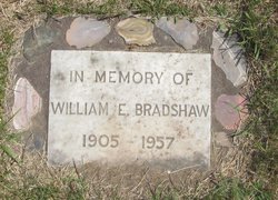
William Edward Bradshaw
| Birth | : | 18 Oct 1905 Thorp, Kittitas County, Washington, USA |
| Death | : | 19 Aug 1957 Seattle, King County, Washington, USA |
| Burial | : | Goodrich Cemetery, Goodrich, Sheridan County, USA |
| Coordinate | : | 47.4716988, -100.1406021 |
| Description | : | OBIT: Death came early Monday morning at Harborview Hospital in Seattle for William Edward Bradshaw, 51, a lifelong resident of the Kittitas Valley. In Ill health for the past eight years and bedridden most of the past five years, Bradshaw had been taken by ambulance to the Seattle Hospital for observation Sunday. Attending physicians said that a circulatory ailment developed shortly after his arrival, causing his death. Bradshaw was born October 18, 1905 on a farm near Thorp and attended Thorp Public Schools. He was married to Miriam Snowden at Kent, Washington, March 6, 1930. They farmed on... Read More |
frequently asked questions (FAQ):
-
Where is William Edward Bradshaw's memorial?
William Edward Bradshaw's memorial is located at: Goodrich Cemetery, Goodrich, Sheridan County, USA.
-
When did William Edward Bradshaw death?
William Edward Bradshaw death on 19 Aug 1957 in Seattle, King County, Washington, USA
-
Where are the coordinates of the William Edward Bradshaw's memorial?
Latitude: 47.4716988
Longitude: -100.1406021
Family Members:
Parent
Siblings

Flowers:


Nearby Cemetories:
1. Goodrich Cemetery
Goodrich, Sheridan County, USA
Coordinate: 47.4716988, -100.1406021
2. Goodrich Seventh-Day Adventist Cemetery
Goodrich, Sheridan County, USA
Coordinate: 47.4803200, -100.1402969
3. Denhoff Catholic Cemetery
Denhoff, Sheridan County, USA
Coordinate: 47.4853247, -100.2673544
4. Denhoff Cemetery
Denhoff, Sheridan County, USA
Coordinate: 47.4839973, -100.2679291
5. Denhoff Adventist Cemetery
Sheridan County, USA
Coordinate: 47.4197006, -100.2446976
6. Saint Jacobus Lutheran Cemetery
Sheridan County, USA
Coordinate: 47.5739100, -100.1917600
7. Fairview Cemetery
Sheridan County, USA
Coordinate: 47.6032982, -100.1502991
8. First German Baptist Church Cemetery
McClusky, Sheridan County, USA
Coordinate: 47.4450684, -100.3536987
9. Pleasant Hill Cemetery
Hurdsfield, Wells County, USA
Coordinate: 47.4364014, -99.9274979
10. Hazel Grove Cemetery
Wing, Burleigh County, USA
Coordinate: 47.3150940, -100.1690700
11. Stark Mennonite Church Cemetery
Wing, Burleigh County, USA
Coordinate: 47.3153800, -100.1770700
12. Zion Cemetery
Sheridan County, USA
Coordinate: 47.6493988, -100.0755997
13. Saint Emanuel Evangelical Lutheran Cemetery
Sheridan County, USA
Coordinate: 47.6594009, -100.2247009
14. McClusky City Cemetery
McClusky, Sheridan County, USA
Coordinate: 47.4801178, -100.4373550
15. Holy Family Catholic Cemetery
McClusky, Sheridan County, USA
Coordinate: 47.4807854, -100.4375076
16. Lincoln Valley Seventh-Day Adventist Cemetery
Lincoln Valley, Sheridan County, USA
Coordinate: 47.6179466, -100.3515167
17. Lincoln Valley Baptist Cemetery
Lincoln Valley, Sheridan County, USA
Coordinate: 47.6469688, -100.2972870
18. Hope Mennonite Cemetery
Wells County, USA
Coordinate: 47.5307999, -99.8422012
19. Saint Petri Lutheran Cemetery
Harvey, Wells County, USA
Coordinate: 47.6176020, -99.9048720
20. Eigenheim Cemetery
Harvey, Wells County, USA
Coordinate: 47.6175620, -99.9046900
21. Hieb-Huft Cemetery
McClusky, Sheridan County, USA
Coordinate: 47.6029100, -100.3952700
22. Harvey Mennonite Brethren Cemetery
Harvey, Wells County, USA
Coordinate: 47.6739006, -100.0260010
23. Chaseley Cemetery
Wells County, USA
Coordinate: 47.4571991, -99.8191986
24. Lincoln Valley Lutheran Cemetery
Lincoln Valley, Sheridan County, USA
Coordinate: 47.6722527, -100.3097916