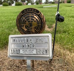
William Henry “Bud” Viner
| Birth | : | 27 Aug 1931 Stanton, Montgomery County, Iowa, USA |
| Death | : | 28 Feb 2021 Council Bluffs, Pottawattamie County, Iowa, USA |
| Burial | : | Emerson Cemetery, Emerson, Mills County, USA |
| Coordinate | : | 41.0325012, -95.4021988 |
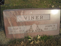
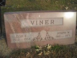
| Description | : | William Henry "Bud" Viner, age 89, of Emerson, Iowa, passed away Sunday, February 28, 2021 at the Jennie Edmundson Hospital in Council Bluffs, Iowa. Bud was born August 27, 1931 in Stanton, Iowa, the son of Joseph William and Elsie Elizabeth (Carlstedt) Viner. He was raised in Villisca, Iowa and Omaha, Nebraska. Bud graduated from South High School in Omaha in 1950. He was a mechanic in Omaha and then moved to Emerson, Iowa, where he started Viner Garage in 1953. Bud served in the Army Reserves from 1954 until 1957. Over the years, he added trucking to the business... Read More |
frequently asked questions (FAQ):
-
Where is William Henry “Bud” Viner's memorial?
William Henry “Bud” Viner's memorial is located at: Emerson Cemetery, Emerson, Mills County, USA.
-
When did William Henry “Bud” Viner death?
William Henry “Bud” Viner death on 28 Feb 2021 in Council Bluffs, Pottawattamie County, Iowa, USA
-
Where are the coordinates of the William Henry “Bud” Viner's memorial?
Latitude: 41.0325012
Longitude: -95.4021988
Family Members:
Parent
Spouse
Siblings
Flowers:
Nearby Cemetories:
1. Emerson Cemetery
Emerson, Mills County, USA
Coordinate: 41.0325012, -95.4021988
2. Lowens Cemetery
Garfield Township, Montgomery County, USA
Coordinate: 41.0527728, -95.3758292
3. North Grove Cemetery
Hastings, Mills County, USA
Coordinate: 41.0161018, -95.4618988
4. Hastings Cemetery
Hastings, Mills County, USA
Coordinate: 41.0097008, -95.4993973
5. Walnut Cemetery
Montgomery County, USA
Coordinate: 40.9519005, -95.3741989
6. South Grove Cemetery
Mills County, USA
Coordinate: 40.9775009, -95.4931030
7. Salem Cemetery
Red Oak, Montgomery County, USA
Coordinate: 40.9733009, -95.3088989
8. Wearin Cemetery
Malvern, Mills County, USA
Coordinate: 41.0395000, -95.5313000
9. Farm Creek Cemetery
Henderson, Mills County, USA
Coordinate: 41.1319008, -95.4186020
10. Wesley Chapel Cemetery
Henderson, Mills County, USA
Coordinate: 41.1019249, -95.4987793
11. Cotten Cemetery
Mills County, USA
Coordinate: 41.0845000, -95.5167000
12. Saylers Farm Cemetery
Henderson, Mills County, USA
Coordinate: 41.1083300, -95.4919440
13. Parker Cemetery
White Cloud, Mills County, USA
Coordinate: 40.9737649, -95.5184363
14. David Farm Cemetery
West Township, Montgomery County, USA
Coordinate: 40.9249960, -95.3766593
15. Gomer Cemetery
Wales, Montgomery County, USA
Coordinate: 41.1171989, -95.3082962
16. Saint Marys Cemetery
Red Oak, Montgomery County, USA
Coordinate: 41.0447006, -95.2275009
17. Buckner Cemetery
Wales, Montgomery County, USA
Coordinate: 41.1595600, -95.3440700
18. Hewitt Cemetery
Red Oak, Montgomery County, USA
Coordinate: 40.9850006, -95.2335968
19. Evergreen Cemetery
Red Oak, Montgomery County, USA
Coordinate: 41.0228004, -95.2205963
20. Malvern Cemetery
Malvern, Mills County, USA
Coordinate: 40.9886017, -95.5785980
21. Monroe Cemetery
Imogene, Fremont County, USA
Coordinate: 40.8880997, -95.4222031
22. Center Ridge Cemetery
Montgomery County, USA
Coordinate: 41.1452141, -95.2787018
23. L Laire Property Cemetery (Defunct)
Sherman Township, Montgomery County, USA
Coordinate: 41.0958257, -95.2224927
24. Saint Clair Cemetery
Red Oak Township, Montgomery County, USA
Coordinate: 41.0598400, -95.2049810


