
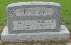
William Henry Foster
| Birth | : | 6 Mar 1900 Maryville, Nodaway County, Missouri, USA |
| Death | : | 8 Sep 1969 Maryville, Nodaway County, Missouri, USA |
| Burial | : | Fairview Cemetery, Council Bluffs, Pottawattamie County, USA |
| Coordinate | : | 41.2703018, -95.8480988 |
| Plot | : | New Central C (6), Row 2 |
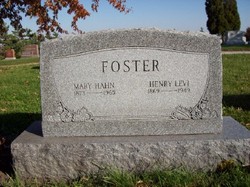
| Description | : | Son of Henry Levi Foster and Mary Hahn Foster. He married Mary Amelia Crawford December 12, 1923. Their children: Gerald and Fred. Final Rites Held for W. H. Foster Final rites were held at 2 p.m. Thursday at the Price Funeral Home for William Henry Foster, Maryville, Missouri, who died Monday. The Rev. Howard Judah officiated and burial was in Oak Hill Cemetery. Ken Bittiker, accompanied by Mrs. Eldon Asbell, sang "No Night There," and "Beyond the Sunset." Pallbearers were James B. Robinson, Lloyd Gutting, Henry DeMott, Frank Garton, Donald Wiederholt, and J. W. Price. Masonic rites were held at the graveside under the... Read More |
frequently asked questions (FAQ):
-
Where is William Henry Foster's memorial?
William Henry Foster's memorial is located at: Fairview Cemetery, Council Bluffs, Pottawattamie County, USA.
-
When did William Henry Foster death?
William Henry Foster death on 8 Sep 1969 in Maryville, Nodaway County, Missouri, USA
-
Where are the coordinates of the William Henry Foster's memorial?
Latitude: 41.2703018
Longitude: -95.8480988
Family Members:
Parent

Spouse

Siblings

Children


Nearby Cemetories:
1. Fairview Cemetery
Council Bluffs, Pottawattamie County, USA
Coordinate: 41.2703018, -95.8480988
2. Ridgewood Cemetery
Council Bluffs, Pottawattamie County, USA
Coordinate: 41.2694016, -95.8272018
3. Walnut Hill Cemetery
Council Bluffs, Pottawattamie County, USA
Coordinate: 41.2719002, -95.8255997
4. Memorial Park Cemetery
Council Bluffs, Pottawattamie County, USA
Coordinate: 41.2644005, -95.8261032
5. Bikhor Cholim Cemetery
Council Bluffs, Pottawattamie County, USA
Coordinate: 41.2703670, -95.8229350
6. Oak Hill Cemetery
Council Bluffs, Pottawattamie County, USA
Coordinate: 41.2700900, -95.8226400
7. Green Valley Cemetery
Council Bluffs, Pottawattamie County, USA
Coordinate: 41.2743988, -95.8225021
8. Saint Joseph Cemetery
Council Bluffs, Pottawattamie County, USA
Coordinate: 41.2722015, -95.8208008
9. Cedar Lawn Cemetery
Council Bluffs, Pottawattamie County, USA
Coordinate: 41.2694016, -95.8182983
10. Clark Cemetery
Pottawattamie County, USA
Coordinate: 41.2551610, -95.8223390
11. Garner Cemetery
Council Bluffs, Pottawattamie County, USA
Coordinate: 41.2956161, -95.8001709
12. Maple Grove Cemetery
Council Bluffs, Pottawattamie County, USA
Coordinate: 41.2265560, -95.8187100
13. Evans Cemetery
Crescent, Pottawattamie County, USA
Coordinate: 41.3255997, -95.8368988
14. Stoker-Graybill Cemetery
Council Bluffs, Pottawattamie County, USA
Coordinate: 41.2532620, -95.7751770
15. Council Point Cemetery
Council Bluffs, Pottawattamie County, USA
Coordinate: 41.2110830, -95.8788610
16. Trinity Cathedral Columbarium
Omaha, Douglas County, USA
Coordinate: 41.2603900, -95.9393660
17. Lewis Township Cemetery
Council Bluffs, Pottawattamie County, USA
Coordinate: 41.2117004, -95.7938995
18. Gregg Cemetery
Weston, Pottawattamie County, USA
Coordinate: 41.3330000, -95.7931000
19. Prospect Hill Cemetery
Omaha, Douglas County, USA
Coordinate: 41.2780991, -95.9593964
20. Hazel Dell Cemetery
Council Bluffs, Pottawattamie County, USA
Coordinate: 41.3489723, -95.7939911
21. First Central Congregational Columbarium
Omaha, Douglas County, USA
Coordinate: 41.2563456, -95.9658365
22. Nash Chapel Crypt
Omaha, Douglas County, USA
Coordinate: 41.2665090, -95.9721790
23. Crescent Cemetery
Crescent, Pottawattamie County, USA
Coordinate: 41.3664894, -95.8566208
24. Douglas County Poor Farm Cemetery
Omaha, Douglas County, USA
Coordinate: 41.2437240, -95.9723480