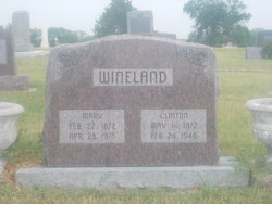
| Birth | : | Apr 1860 Pottawattamie County, Iowa, USA |
| Death | : | 20 Dec 1946 Osborne County, Kansas, USA |
| Burial | : | Kill Creek Cemetery, Alton, Osborne County, USA |
| Coordinate | : | 39.3805528, -98.8967658 |
| Description | : | OSBORNE FARMER JOURNAL Monday Dec. 23, 1946 Marshal Wineland Succumbed Friday Kill Creek Pioneer Passed On Friday, December 20, After a Short Illness The Angel of Death has called Marshal Wineland, one of the last pioneers of Kill Creek neighborhood. His first connection with Kansas occurred when Kansas was still a territory, extending from the Missouri River to the Rocky Mountians. In the spring of 1860 when Marshal was three weeks old his parents, Mr. and Mrs. John Wineland took him with them on a trip to Denver, where silver had recently been discovered. The journey was made in a lumber wagon pulled by an... Read More |
frequently asked questions (FAQ):
-
Where is William Marshall Wineland's memorial?
William Marshall Wineland's memorial is located at: Kill Creek Cemetery, Alton, Osborne County, USA.
-
When did William Marshall Wineland death?
William Marshall Wineland death on 20 Dec 1946 in Osborne County, Kansas, USA
-
Where are the coordinates of the William Marshall Wineland's memorial?
Latitude: 39.3805528
Longitude: -98.8967658
Family Members:
Parent
Spouse
Siblings
Children
Flowers:
Nearby Cemetories:
1. Kill Creek Cemetery
Alton, Osborne County, USA
Coordinate: 39.3805528, -98.8967658
2. Mount Hope Cemetery
Bloomington, Osborne County, USA
Coordinate: 39.3939018, -98.8450012
3. Mount Ayr Cemetery
Alton, Osborne County, USA
Coordinate: 39.3764000, -98.9717026
4. Sumner Cemetery
Alton, Osborne County, USA
Coordinate: 39.4799995, -98.9338913
5. Bloomington Cemetery
Bloomington, Osborne County, USA
Coordinate: 39.4669800, -98.8120800
6. Pioneer Cemetery
Alton, Osborne County, USA
Coordinate: 39.4742012, -98.9749985
7. Covert Cemetery
Osborne County, USA
Coordinate: 39.2896996, -98.8107986
8. Pleasant Valley Cemetery
Osborne County, USA
Coordinate: 39.4583015, -99.0077972
9. Bristow Cemetery
Osborne, Osborne County, USA
Coordinate: 39.3506012, -98.7506027
10. Pleasant Plain Cemetery
Osborne County, USA
Coordinate: 39.3367004, -99.0372009
11. Round Mound Cemetery
Osborne County, USA
Coordinate: 39.2630997, -98.9636002
12. IXL Cemetery
Natoma, Osborne County, USA
Coordinate: 39.2491989, -98.9218979
13. Cedar Bluff Cemetery
Osborne County, USA
Coordinate: 39.2496986, -98.8431015
14. Immanuel Lutheran Cemetery
Natoma, Osborne County, USA
Coordinate: 39.2708015, -99.0096970
15. Victor Cemetery
Osborne County, USA
Coordinate: 39.2380981, -98.8613968
16. Grant Center Cemetery
Alton, Osborne County, USA
Coordinate: 39.5242004, -98.9708023
17. Chalk Mound Cemetery
Laton, Rooks County, USA
Coordinate: 39.3208008, -99.0852966
18. Osborne Cemetery
Osborne, Osborne County, USA
Coordinate: 39.4514008, -98.7138977
19. Cole Cemetery
Osborne County, USA
Coordinate: 39.2352982, -98.8060989
20. Butler Cemetery
Osborne County, USA
Coordinate: 39.5400009, -98.8494034
21. Saint Aloysius Cemetery
Osborne, Osborne County, USA
Coordinate: 39.4536018, -98.6903000
22. Aurora Cemetery
Laton, Rooks County, USA
Coordinate: 39.2778015, -99.0847015
23. Spring Branch Cemetery
Woodston, Rooks County, USA
Coordinate: 39.5099983, -99.0580978
24. Survey Cemetery
Woodston, Rooks County, USA
Coordinate: 39.3722000, -99.1333008


