
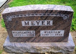
William Meyer
| Birth | : | 1877 |
| Death | : | 1943 |
| Burial | : | All Saints Churchyard, West Acre, Kings Lynn and West Norfolk Borough, England |
| Coordinate | : | 52.7055420, 0.6339660 |
frequently asked questions (FAQ):
-
Where is William Meyer's memorial?
William Meyer's memorial is located at: All Saints Churchyard, West Acre, Kings Lynn and West Norfolk Borough, England.
-
When did William Meyer death?
William Meyer death on 1943 in
-
Where are the coordinates of the William Meyer's memorial?
Latitude: 52.7055420
Longitude: 0.6339660
Family Members:
Spouse

Flowers:


Nearby Cemetories:
1. All Saints Churchyard
West Acre, Kings Lynn and West Norfolk Borough, England
Coordinate: 52.7055420, 0.6339660
2. Exton Hall Roman Catholic Chapel
Exton, Rutland Unitary Authority, England
Coordinate: 52.6925000, 0.6382000
3. St. Mary's Churchyard
Narford, Breckland Borough, England
Coordinate: 52.6928740, 0.6095600
4. St George's Churchyard
Southacre, Breckland Borough, England
Coordinate: 52.6962700, 0.6769400
5. St James The Great Churchyard
Castle Acre, Kings Lynn and West Norfolk Borough, England
Coordinate: 52.7023700, 0.6861000
6. Saint Mary Churchyard
East Walton, Kings Lynn and West Norfolk Borough, England
Coordinate: 52.7146600, 0.5787130
7. All Saints Churchyard
Narborough, Breckland Borough, England
Coordinate: 52.6861790, 0.5825420
8. St. Mary's Churchyard
Gayton Thorpe, Kings Lynn and West Norfolk Borough, England
Coordinate: 52.7362310, 0.5832080
9. St. Mary and All Saints Churchyard
Newton by Castle Acre, Breckland Borough, England
Coordinate: 52.7061570, 0.7085120
10. St. Mary Magdalene Churchyard
Pentney, Kings Lynn and West Norfolk Borough, England
Coordinate: 52.6950490, 0.5449550
11. St Cecilia's Churchyard
West Bilney, Kings Lynn and West Norfolk Borough, England
Coordinate: 52.7079810, 0.5395750
12. St Nicholas Churchyard
Gayton, Kings Lynn and West Norfolk Borough, England
Coordinate: 52.7435700, 0.5615600
13. St. Mary's Churchyard
Sporle, Breckland Borough, England
Coordinate: 52.6694460, 0.7342630
14. St Mary's Churchyard
Great Massingham, Kings Lynn and West Norfolk Borough, England
Coordinate: 52.7743160, 0.6652320
15. St. Andrew's Churchyard
East Lexham, Breckland Borough, England
Coordinate: 52.7200190, 0.7522010
16. Pentney Priory
Pentney, Kings Lynn and West Norfolk Borough, England
Coordinate: 52.6803890, 0.5143830
17. St. Margaret's Churchyard
Little Dunham, Breckland Borough, England
Coordinate: 52.6822220, 0.7551140
18. Marham Cemetery
Marham, Kings Lynn and West Norfolk Borough, England
Coordinate: 52.6622260, 0.5287110
19. Saint Botolphs Churchyard
Grimston, Kings Lynn and West Norfolk Borough, England
Coordinate: 52.7671870, 0.5509690
20. All Saints Churchyard
Ashwicken, Kings Lynn and West Norfolk Borough, England
Coordinate: 52.7404620, 0.5146680
21. All Saints Churchyard
East Winch, Kings Lynn and West Norfolk Borough, England
Coordinate: 52.7175790, 0.5025340
22. St. Andrew's Churchyard
Little Massingham, Kings Lynn and West Norfolk Borough, England
Coordinate: 52.7851360, 0.6566710
23. Holy Trinity Churchyard
Marham, Kings Lynn and West Norfolk Borough, England
Coordinate: 52.6583800, 0.5236900
24. St. Andrew's Churchyard
Great Dunham, Breckland Borough, England
Coordinate: 52.6976440, 0.7715910