
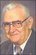
William O. Sagers
| Birth | : | 1911 |
| Death | : | 6 Apr 2007 Maquoketa, Jackson County, Iowa, USA |
| Burial | : | St John the Baptist, Acklam, Ryedale District, England |
| Coordinate | : | 54.0451010, -0.8006330 |
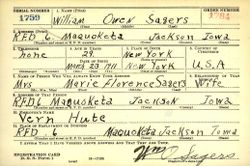
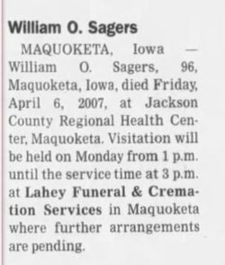
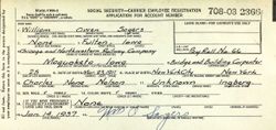
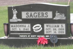
| Description | : | Father of Nancy Clark of Maquoketa, IA. the Gazette William O. Sagers Quad-City Times, The (IA) - Sunday, April 8, 2007MAQUOKETA, Iowa - William O. Sagers, 96, of Maquoketa, died Friday, April 6, 2007, at the Jackson County Regional Health Center, Maquoketa. A celebration of his life will be held Monday, April 9, 2007, at 3 p.m. at Lahey Funeral Home in Maquoketa. Family and friends may call on Monday from 1 p.m. until the service time at the funeral home. Burial will be in Mt. Hope Cemetery, Maquoketa. Memorials are preferred.William Owen Sagers (born William Irving Nelson) was born on March 23,... Read More |
frequently asked questions (FAQ):
-
Where is William O. Sagers's memorial?
William O. Sagers's memorial is located at: St John the Baptist, Acklam, Ryedale District, England.
-
When did William O. Sagers death?
William O. Sagers death on 6 Apr 2007 in Maquoketa, Jackson County, Iowa, USA
-
Where are the coordinates of the William O. Sagers's memorial?
Latitude: 54.0451010
Longitude: -0.8006330
Family Members:
Spouse

Children
Flowers:


Nearby Cemetories:
1. St John the Baptist
Acklam, Ryedale District, England
Coordinate: 54.0451010, -0.8006330
2. Burythorpe Churchyard
Burythorpe, Ryedale District, England
Coordinate: 54.0752951, -0.7955984
3. All Saints Churchyard
Kirby Underdale, East Riding of Yorkshire Unitary Authority, England
Coordinate: 54.0166200, -0.7677100
4. St Andrew Churchyard
Bugthorpe, East Riding of Yorkshire Unitary Authority, England
Coordinate: 54.0108100, -0.8226900
5. St Mary Churchyard
Birdsall, Ryedale District, England
Coordinate: 54.0780000, -0.7508000
6. Howsham Churchyard
Howsham, Ryedale District, England
Coordinate: 54.0565520, -0.8755670
7. St. Mary's Churchyard
Westow, Ryedale District, England
Coordinate: 54.0846190, -0.8406850
8. St Peter and St Paul Churchyard
Scrayingham, Ryedale District, England
Coordinate: 54.0342510, -0.8826130
9. St Andrew Churchyard
Langton, Ryedale District, England
Coordinate: 54.0934510, -0.7834680
10. St. Mary's Churchyard
Thixendale, Ryedale District, England
Coordinate: 54.0387360, -0.7154888
11. St Michael Churchyard
Crambe, Ryedale District, England
Coordinate: 54.0744550, -0.8809390
12. St John the Evangelist Churchyard
Buttercrambe, Ryedale District, England
Coordinate: 54.0137300, -0.8812900
13. Kirkham Priory
Kirkham, Ryedale District, England
Coordinate: 54.0826180, -0.8768470
14. St. Edith Churchyard
Bishop Wilton, East Riding of Yorkshire Unitary Authority, England
Coordinate: 53.9862300, -0.7838500
15. St Botolph Churchyard
Bossall, Ryedale District, England
Coordinate: 54.0375570, -0.9047540
16. St Mary Churchyard
Full Sutton, East Riding of Yorkshire Unitary Authority, England
Coordinate: 53.9897620, -0.8613700
17. St. Margaret's Churchyard
Huttons Ambo, Ryedale District, England
Coordinate: 54.1066490, -0.8490640
18. St. Martin Churchyard
Wharram Percy, Ryedale District, England
Coordinate: 54.0665700, -0.6901300
19. St. Nicholas Churchyard
North Grimston, Ryedale District, England
Coordinate: 54.0989220, -0.7148680
20. St Ethelburga Churchyard
Great Givendale, East Riding of Yorkshire Unitary Authority, England
Coordinate: 53.9745030, -0.7617170
21. St Martin Churchyard
Fangfoss, East Riding of Yorkshire Unitary Authority, England
Coordinate: 53.9704970, -0.8324690
22. St. Mary's Churchyard
Wharram le Street, Ryedale District, England
Coordinate: 54.0820040, -0.6810779
23. St John the Evangelist Churchyard
Welburn (Malton), Ryedale District, England
Coordinate: 54.1008850, -0.8985440
24. St. Mary's Churchyard
Fridaythorpe, East Riding of Yorkshire Unitary Authority, England
Coordinate: 54.0220090, -0.6667190