
Winnifred Belau Horning
| Birth | : | 1890 |
| Death | : | 1995 |
| Burial | : | St. John's Churchyard, Hornton, Cherwell District, England |
| Coordinate | : | 52.1020090, -1.4287560 |
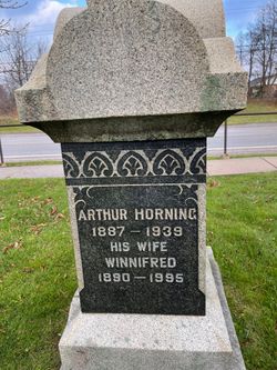
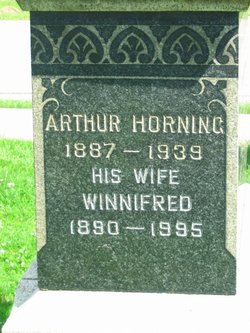
| Inscription | : | Arthur Horning, 1887-1939; His wife, Winnifred, 1890-1995. |
| Description | : | Wife of Arthur Horning. |
frequently asked questions (FAQ):
-
Where is Winnifred Belau Horning's memorial?
Winnifred Belau Horning's memorial is located at: St. John's Churchyard, Hornton, Cherwell District, England.
-
When did Winnifred Belau Horning death?
Winnifred Belau Horning death on 1995 in
-
Where are the coordinates of the Winnifred Belau Horning's memorial?
Latitude: 52.1020090
Longitude: -1.4287560
Family Members:

Flowers:


Nearby Cemetories:
1. St. John's Churchyard
Hornton, Cherwell District, England
Coordinate: 52.1020090, -1.4287560
2. Ratley St Peter Ad Vincula Churchyard
Ratley and Upton, Stratford-on-Avon District, England
Coordinate: 52.1228440, -1.4411190
3. St Michael and All Angels Churchyard
Alkerton, Cherwell District, England
Coordinate: 52.0834080, -1.4509680
4. St Etheldreda Churchyard
Horley, Cherwell District, England
Coordinate: 52.0924610, -1.3930320
5. St Michael Churchyard
Warmington, Stratford-on-Avon District, England
Coordinate: 52.1241420, -1.4028940
6. St. Laurence Churchyard
Shotteswell, Stratford-on-Avon District, England
Coordinate: 52.1061720, -1.3787950
7. St Peter Church
Radway, Stratford-on-Avon District, England
Coordinate: 52.1298000, -1.4636000
8. All Saints Churchyard
Wroxton, Cherwell District, England
Coordinate: 52.0726220, -1.3925790
9. St. Peters Churchyard
Hanwell, Cherwell District, England
Coordinate: 52.0887920, -1.3657000
10. St Peter's Churchyard
Drayton, Cherwell District, England
Coordinate: 52.0707360, -1.3764670
11. St Mary's churchyard
Tysoe, Stratford-on-Avon District, England
Coordinate: 52.0966300, -1.5036400
12. St. Joseph's Churchyard
Avon Dassett, Stratford-on-Avon District, England
Coordinate: 52.1464266, -1.4020356
13. St. John The Baptist Churchyard
Avon Dassett, Stratford-on-Avon District, England
Coordinate: 52.1479847, -1.4002128
14. All Saint's Churchyard
Mollington, Cherwell District, England
Coordinate: 52.1238200, -1.3557600
15. St Anne's Parish Church
Epwell, Cherwell District, England
Coordinate: 52.0615780, -1.4866280
16. St. Botolph's Churchyard
Farnborough, Stratford-on-Avon District, England
Coordinate: 52.1427340, -1.3675320
17. Banbury Crematorium
Banbury, Cherwell District, England
Coordinate: 52.0865540, -1.3406860
18. All Saints' Church Great Bourton
Bourton, Cherwell District, England
Coordinate: 52.1062460, -1.3349970
19. Hardwick Hill Cemetery
Banbury, Cherwell District, England
Coordinate: 52.0864530, -1.3381430
20. All Saints Churchyard
Burton Dassett, Stratford-on-Avon District, England
Coordinate: 52.1609570, -1.4200750
21. Compton Wynyates Burial Grounds
Compton Wynyates, Stratford-on-Avon District, England
Coordinate: 52.0747020, -1.5198000
22. Southam Road Cemetery
Banbury, Cherwell District, England
Coordinate: 52.0679120, -1.3405760
23. St Nicholas Churchyard
Tadmarton, Cherwell District, England
Coordinate: 52.0377060, -1.4295690
24. St Mary the Virgin Churchyard
Broughton, Cherwell District, England
Coordinate: 52.0417020, -1.3912030