
| Memorials | : | 3 |
| Location | : | Horley, Cherwell District, England |
| Coordinate | : | 52.0924610, -1.3930320 |
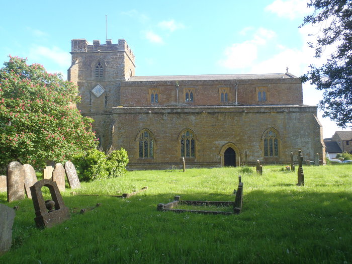
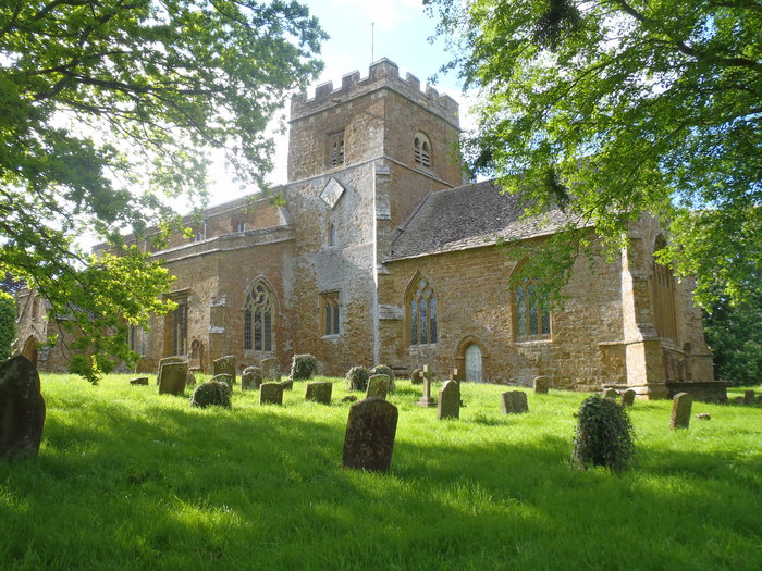
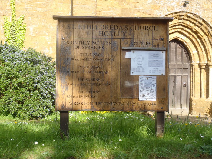
| Description | : | The church dedicated to St Etheldreda is situated on a hilltop overlooking the village. It is Grade 1 Listed. An excellent example of a medieval church. Dating from Norman to 13C/14C. It has three fine Early English doorways. Several wall paintings and a large wall painting of St Christopher, with the earliest depiction of rod and line anglers in this country, fishing by the light of the stars. Four architectural periods are harmonised in the building: Norman walls to chancel and font, through Early English, Decorated and Perpendicular. Two 15C stained glass windows. The... Read More |
frequently asked questions (FAQ):
-
Where is St Etheldreda Churchyard?
St Etheldreda Churchyard is located at Church Lane Horley, Cherwell District ,Oxfordshire , OX15 6BJEngland.
-
St Etheldreda Churchyard cemetery's updated grave count on graveviews.com?
2 memorials
-
Where are the coordinates of the St Etheldreda Churchyard?
Latitude: 52.0924610
Longitude: -1.3930320
Nearby Cemetories:
1. St. Laurence Churchyard
Shotteswell, Stratford-on-Avon District, England
Coordinate: 52.1061720, -1.3787950
2. St. Peters Churchyard
Hanwell, Cherwell District, England
Coordinate: 52.0887920, -1.3657000
3. All Saints Churchyard
Wroxton, Cherwell District, England
Coordinate: 52.0726220, -1.3925790
4. St. John's Churchyard
Hornton, Cherwell District, England
Coordinate: 52.1020090, -1.4287560
5. St Peter's Churchyard
Drayton, Cherwell District, England
Coordinate: 52.0707360, -1.3764670
6. St Michael Churchyard
Warmington, Stratford-on-Avon District, England
Coordinate: 52.1241420, -1.4028940
7. Banbury Crematorium
Banbury, Cherwell District, England
Coordinate: 52.0865540, -1.3406860
8. Hardwick Hill Cemetery
Banbury, Cherwell District, England
Coordinate: 52.0864530, -1.3381430
9. St Michael and All Angels Churchyard
Alkerton, Cherwell District, England
Coordinate: 52.0834080, -1.4509680
10. All Saints' Church Great Bourton
Bourton, Cherwell District, England
Coordinate: 52.1062460, -1.3349970
11. All Saint's Churchyard
Mollington, Cherwell District, England
Coordinate: 52.1238200, -1.3557600
12. Southam Road Cemetery
Banbury, Cherwell District, England
Coordinate: 52.0679120, -1.3405760
13. Ratley St Peter Ad Vincula Churchyard
Ratley and Upton, Stratford-on-Avon District, England
Coordinate: 52.1228440, -1.4411190
14. St. Mary the Virgin Churchyard
Banbury, Cherwell District, England
Coordinate: 52.0614620, -1.3391870
15. St. John the Evangelist Churchyard
Banbury, Cherwell District, England
Coordinate: 52.0598790, -1.3400100
16. St Mary the Virgin Churchyard
Broughton, Cherwell District, England
Coordinate: 52.0417020, -1.3912030
17. St. Botolph's Churchyard
Farnborough, Stratford-on-Avon District, England
Coordinate: 52.1427340, -1.3675320
18. St. Mary the Virgin Churchyard
Cropredy, Cherwell District, England
Coordinate: 52.1163600, -1.3165570
19. St. Joseph's Churchyard
Avon Dassett, Stratford-on-Avon District, England
Coordinate: 52.1464266, -1.4020356
20. St. John The Baptist Churchyard
Avon Dassett, Stratford-on-Avon District, England
Coordinate: 52.1479847, -1.4002128
21. St Peter Church
Radway, Stratford-on-Avon District, England
Coordinate: 52.1298000, -1.4636000
22. St Nicholas Churchyard
Tadmarton, Cherwell District, England
Coordinate: 52.0377060, -1.4295690
23. Bodicote Cemetery
Bodicote, Cherwell District, England
Coordinate: 52.0391710, -1.3397380
24. St. Peter and St. Paul Churchyard
Swalcliffe, Cherwell District, England
Coordinate: 52.0380790, -1.4497340