
| Memorials | : | 2 |
| Location | : | Bourton, Cherwell District, England |
| Coordinate | : | 52.1062460, -1.3349970 |
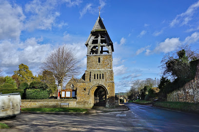
| Description | : | The village church, All Saints' Church, stands prominently in the centre of the village. Although originally 13th century the church was rebuilt almost entirely in the 19th century. The west wall of the nave has a recess containing a small bell which was cast in 1673. When the church was rebuilt the unusual bell tower, separate from the church, was built over the lychgate and is one of only three such bell towers in Britain. A mile to the south is the hamlet of Little Bourton, a mixture of local ironstone cottages, modern bungalows and a farm. Great Bourton is about... Read More |
frequently asked questions (FAQ):
-
Where is All Saints' Church Great Bourton?
All Saints' Church Great Bourton is located at off the A423 Banbury to Coventry road Bourton, Cherwell District ,Oxfordshire ,England.
-
All Saints' Church Great Bourton cemetery's updated grave count on graveviews.com?
2 memorials
-
Where are the coordinates of the All Saints' Church Great Bourton?
Latitude: 52.1062460
Longitude: -1.3349970
Nearby Cemetories:
1. St. Mary the Virgin Churchyard
Cropredy, Cherwell District, England
Coordinate: 52.1163600, -1.3165570
2. Hardwick Hill Cemetery
Banbury, Cherwell District, England
Coordinate: 52.0864530, -1.3381430
3. Banbury Crematorium
Banbury, Cherwell District, England
Coordinate: 52.0865540, -1.3406860
4. All Saint's Churchyard
Mollington, Cherwell District, England
Coordinate: 52.1238200, -1.3557600
5. St. Peters Churchyard
Hanwell, Cherwell District, England
Coordinate: 52.0887920, -1.3657000
6. St. Laurence Churchyard
Shotteswell, Stratford-on-Avon District, England
Coordinate: 52.1061720, -1.3787950
7. St. Mary Magdalene Churchyard
Wardington, Cherwell District, England
Coordinate: 52.1131949, -1.2841641
8. St. Peter and St. Paul Churchyard
Chacombe, South Northamptonshire Borough, England
Coordinate: 52.0916900, -1.2850100
9. St Etheldreda Churchyard
Horley, Cherwell District, England
Coordinate: 52.0924610, -1.3930320
10. Southam Road Cemetery
Banbury, Cherwell District, England
Coordinate: 52.0679120, -1.3405760
11. St. James Churchyard
Claydon, Cherwell District, England
Coordinate: 52.1467460, -1.3334590
12. St. Botolph's Churchyard
Farnborough, Stratford-on-Avon District, England
Coordinate: 52.1427340, -1.3675320
13. St Peter's Churchyard
Drayton, Cherwell District, England
Coordinate: 52.0707360, -1.3764670
14. St. Mary the Virgin Churchyard
Banbury, Cherwell District, England
Coordinate: 52.0614620, -1.3391870
15. St Michael Churchyard
Warmington, Stratford-on-Avon District, England
Coordinate: 52.1241420, -1.4028940
16. St. John the Evangelist Churchyard
Banbury, Cherwell District, England
Coordinate: 52.0598790, -1.3400100
17. Eydon Burial Ground
Eydon, South Northamptonshire Borough, England
Coordinate: 52.1347200, -1.2724300
18. All Saints Churchyard
Wroxton, Cherwell District, England
Coordinate: 52.0726220, -1.3925790
19. All Saints Churchyard
Middleton Cheney, South Northamptonshire Borough, England
Coordinate: 52.0741984, -1.2740247
20. St Mary Church
Warkworth, South Northamptonshire Borough, England
Coordinate: 52.0627000, -1.2917000
21. Middleton Cheney Cemetery
Middleton Cheney, South Northamptonshire Borough, England
Coordinate: 52.0745100, -1.2692900
22. St. Joseph's Churchyard
Avon Dassett, Stratford-on-Avon District, England
Coordinate: 52.1464266, -1.4020356
23. St. John's Churchyard
Hornton, Cherwell District, England
Coordinate: 52.1020090, -1.4287560
24. St. John The Baptist Churchyard
Avon Dassett, Stratford-on-Avon District, England
Coordinate: 52.1479847, -1.4002128