
| Memorials | : | 22 |
| Location | : | Banbury, Cherwell District, England |
| Website | : | www.banbury.gov.uk/Southam_Road_Cemetery_16585.aspx |
| Coordinate | : | 52.0679120, -1.3405760 |
frequently asked questions (FAQ):
-
Where is Southam Road Cemetery?
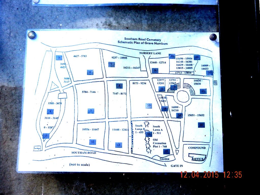
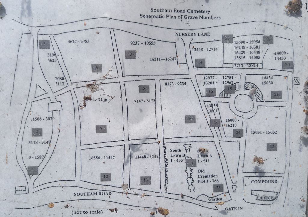
Southam Road Cemetery is located at Southam Road Banbury, Cherwell District ,Oxfordshire , OX16 2EWEngland.
-
Southam Road Cemetery cemetery's updated grave count on graveviews.com?
21 memorials
-
Where are the coordinates of the Southam Road Cemetery?
Latitude: 52.0679120
Longitude: -1.3405760
Nearby Cemetories:
1. St. Mary the Virgin Churchyard
Banbury, Cherwell District, England
Coordinate: 52.0614620, -1.3391870
2. St. John the Evangelist Churchyard
Banbury, Cherwell District, England
Coordinate: 52.0598790, -1.3400100
3. Hardwick Hill Cemetery
Banbury, Cherwell District, England
Coordinate: 52.0864530, -1.3381430
4. Banbury Crematorium
Banbury, Cherwell District, England
Coordinate: 52.0865540, -1.3406860
5. St Peter's Churchyard
Drayton, Cherwell District, England
Coordinate: 52.0707360, -1.3764670
6. St. Peters Churchyard
Hanwell, Cherwell District, England
Coordinate: 52.0887920, -1.3657000
7. Bodicote Cemetery
Bodicote, Cherwell District, England
Coordinate: 52.0391710, -1.3397380
8. St Mary Church
Warkworth, South Northamptonshire Borough, England
Coordinate: 52.0627000, -1.2917000
9. All Saints Churchyard
Wroxton, Cherwell District, England
Coordinate: 52.0726220, -1.3925790
10. Saint John the Baptist Churchyard
Bodicote, Cherwell District, England
Coordinate: 52.0356100, -1.3305700
11. All Saints' Church Great Bourton
Bourton, Cherwell District, England
Coordinate: 52.1062460, -1.3349970
12. St Etheldreda Churchyard
Horley, Cherwell District, England
Coordinate: 52.0924610, -1.3930320
13. St Mary the Virgin Churchyard
Broughton, Cherwell District, England
Coordinate: 52.0417020, -1.3912030
14. All Saints Churchyard
Middleton Cheney, South Northamptonshire Borough, England
Coordinate: 52.0741984, -1.2740247
15. St. Peter and St. Paul Churchyard
Chacombe, South Northamptonshire Borough, England
Coordinate: 52.0916900, -1.2850100
16. Middleton Cheney Cemetery
Middleton Cheney, South Northamptonshire Borough, England
Coordinate: 52.0745100, -1.2692900
17. St. Laurence Churchyard
Shotteswell, Stratford-on-Avon District, England
Coordinate: 52.1061720, -1.3787950
18. St. Mary the Virgin Churchyard
Cropredy, Cherwell District, England
Coordinate: 52.1163600, -1.3165570
19. St Mary's Churchyard
Bloxham, Cherwell District, England
Coordinate: 52.0181100, -1.3748900
20. Adderbury Parish Cemetery
Adderbury, Cherwell District, England
Coordinate: 52.0139537, -1.3246874
21. St Mary the Virgin Churchyard
Adderbury, Cherwell District, England
Coordinate: 52.0148420, -1.3152270
22. St John the Evangelist
Milton, Cherwell District, England
Coordinate: 52.0117900, -1.3452510
23. All Saint's Churchyard
Mollington, Cherwell District, England
Coordinate: 52.1238200, -1.3557600
24. St. Mary Magdalene Churchyard
Wardington, Cherwell District, England
Coordinate: 52.1131949, -1.2841641