
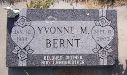
Yvonne Marie Speas Bernt
| Birth | : | 10 Jan 1934 Saint Edward, Boone County, Nebraska, USA |
| Death | : | 17 Sep 2000 Grand Island, Hall County, Nebraska, USA |
| Burial | : | St. Anne Churchyard, Fence, Pendle Borough, England |
| Coordinate | : | 53.8304372, -2.2679552 |
| Description | : | Thanks to contributor #48796369 Yvonne M. Bernt, 66, of Spalding died Sunday, Sept. 17, 2000, at St. Francis Skilled Care Center in Grand Island. Services will be at 10:30 a.m. Thursday at St. Michael's Catholic Church in Spalding. Burial will be in the church cemetery. Visitation will be from 3:30 to 5 p.m. and 7:30 to 9 p.m., with rosaries at 4:30 and 8:15 p.m., Wednesday at the church. Dolce-Scheef Mortuary of Spalding is in charge of arrangements. Mrs. Bernt was born on Jan. 10, 1934, in St. Edward to Robert and Margaret (Hittner) Speas. She... Read More |
frequently asked questions (FAQ):
-
Where is Yvonne Marie Speas Bernt's memorial?
Yvonne Marie Speas Bernt's memorial is located at: St. Anne Churchyard, Fence, Pendle Borough, England.
-
When did Yvonne Marie Speas Bernt death?
Yvonne Marie Speas Bernt death on 17 Sep 2000 in Grand Island, Hall County, Nebraska, USA
-
Where are the coordinates of the Yvonne Marie Speas Bernt's memorial?
Latitude: 53.8304372
Longitude: -2.2679552
Family Members:
Parent

Spouse
Siblings
Flowers:


Nearby Cemetories:
1. St. Anne Churchyard
Fence, Pendle Borough, England
Coordinate: 53.8304372, -2.2679552
2. Wheatley Lane Methodist Churchyard
Fence, Pendle Borough, England
Coordinate: 53.8341457, -2.2596202
3. St John Churchyard
Higham, Pendle Borough, England
Coordinate: 53.8251420, -2.2898120
4. Wheatley Lane Inghamite Church Churchyard
Wheatley Lane, Pendle Borough, England
Coordinate: 53.8412800, -2.2457100
5. St. Mary's Churchyard
Newchurch in Pendle, Pendle Borough, England
Coordinate: 53.8504181, -2.2706807
6. All Souls Cemetery
Barrowford, Pendle Borough, England
Coordinate: 53.8462900, -2.2355600
7. Marsden Friends Burial Ground
Marsden, Metropolitan Borough of Kirklees, England
Coordinate: 53.8241910, -2.2197410
8. St. Paul's Churchyard
Nelson, Pendle Borough, England
Coordinate: 53.8289250, -2.2157520
9. St. Thomas Churchyard
Barrowford, Pendle Borough, England
Coordinate: 53.8513900, -2.2196600
10. All Saints Churchyard
Habergham Eaves, Burnley Borough, England
Coordinate: 53.7971060, -2.2913770
11. Ebenezer Baptist Chapel Chapelyard
Burnley, Burnley Borough, England
Coordinate: 53.7975120, -2.2397260
12. Saint Nicholas Parish Churchyard
Sabden, Ribble Valley Borough, England
Coordinate: 53.8346503, -2.3332764
13. Barrowford Cemetery
Nelson, Pendle Borough, England
Coordinate: 53.8521100, -2.2130300
14. St. Leonard's Churchyard
Padiham, Burnley Borough, England
Coordinate: 53.8022600, -2.3164300
15. Holy Trinity Churchyard
Burnley, Burnley Borough, England
Coordinate: 53.7898290, -2.2574200
16. Wesleyan Methodist Chapel Chapelyard
Padiham, Burnley Borough, England
Coordinate: 53.8018980, -2.3181730
17. St. Peter's Churchyard
Burnley, Burnley Borough, England
Coordinate: 53.7924450, -2.2394890
18. St. John the Evangelist Churchyard
Nelson, Pendle Borough, England
Coordinate: 53.8367000, -2.1977200
19. St. James' Churchyard
Burnley, Burnley Borough, England
Coordinate: 53.7905590, -2.2458280
20. St. James' Churchyard
Briercliffe, Burnley Borough, England
Coordinate: 53.8107700, -2.2031800
21. Nelson Cemetery
Nelson, Pendle Borough, England
Coordinate: 53.8420330, -2.1972230
22. St Leonard Churchyard Extension
Padiham, Burnley Borough, England
Coordinate: 53.7991800, -2.3222000
23. St. John's Cemetery
Padiham, Burnley Borough, England
Coordinate: 53.7948720, -2.3145290
24. Haggate Baptist Church Burial Ground
Burnley Borough, England
Coordinate: 53.8145048, -2.1960725