
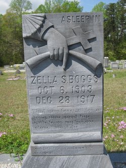

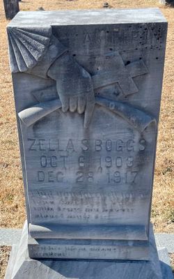
Zella Sloan Boggs
| Birth | : | 6 Oct 1903 Oconee County, South Carolina, USA |
| Death | : | 28 Dec 1917 Oconee County, South Carolina, USA |
| Burial | : | Clayton Center Cemetery, Clayton Center, Clayton County, USA |
| Coordinate | : | 42.8841705, -91.3225021 |
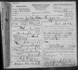
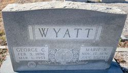
| Description | : | FATAL ACCIDENT AT NEW HOPE Miss Zella Boggs Lost Life When Auto Turned Over. The first fatal automobile accident for Oconee occurred last Friday afternoon in the New Hope section when a car driven by George Wyatt turned over, throwing the seven occupants of the car out, killing Miss Zella Boggs, seriously injuring young Wyatt and injuring slightly some of the other occupants. The cause of the accident is said to have been a defect in the steering gear of the machine. Young Wyatt purchased the car second-hand in Walhalla only a few days before the accident and just what... Read More |
frequently asked questions (FAQ):
-
Where is Zella Sloan Boggs's memorial?
Zella Sloan Boggs's memorial is located at: Clayton Center Cemetery, Clayton Center, Clayton County, USA.
-
When did Zella Sloan Boggs death?
Zella Sloan Boggs death on 28 Dec 1917 in Oconee County, South Carolina, USA
-
Where are the coordinates of the Zella Sloan Boggs's memorial?
Latitude: 42.8841705
Longitude: -91.3225021
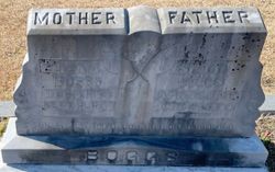
Family Members:
Parent

Siblings
Flowers:


Nearby Cemetories:
1. Clayton Center Cemetery
Clayton Center, Clayton County, USA
Coordinate: 42.8841705, -91.3225021
2. Zion Lutheran Cemetery
Clayton Center, Clayton County, USA
Coordinate: 42.8841705, -91.3249969
3. County Home Cemetery
Clayton Center, Clayton County, USA
Coordinate: 42.8916702, -91.3499985
4. Colony Catholic Cemetery (Defunct)
Read Township, Clayton County, USA
Coordinate: 42.8830000, -91.3580000
5. Saint Joseph Cemetery
Garnavillo, Clayton County, USA
Coordinate: 42.8628006, -91.2502975
6. Garnavillo Community Cemetery
Garnavillo, Clayton County, USA
Coordinate: 42.8656000, -91.2422100
7. Garnavillo Cemetery
Garnavillo, Clayton County, USA
Coordinate: 42.8660300, -91.2390100
8. Elkader Cemetery
Elkader, Clayton County, USA
Coordinate: 42.8541718, -91.4000015
9. Saint Josephs Cemetery
Elkader, Clayton County, USA
Coordinate: 42.8488998, -91.4021988
10. Farmersburg-Wagner Cemetery
Farmersburg, Clayton County, USA
Coordinate: 42.9481010, -91.3700027
11. National Cemetery
National, Clayton County, USA
Coordinate: 42.9536018, -91.2902985
12. Hartman Cemetery
Cox Creek Township, Clayton County, USA
Coordinate: 42.8155360, -91.3880840
13. Meenan Cemetery
Communia, Clayton County, USA
Coordinate: 42.7999862, -91.3584693
14. Krumm Cemetery
Garber, Clayton County, USA
Coordinate: 42.7913760, -91.3023559
15. Norway Lutheran Church Cemetery
Saint Olaf, Clayton County, USA
Coordinate: 42.9352798, -91.4302826
16. Bismark Cemetery
Farmersburg, Clayton County, USA
Coordinate: 42.9790000, -91.3500000
17. Patterson Pioneer Cemetery
Saint Olaf, Clayton County, USA
Coordinate: 42.9216000, -91.4489000
18. Communia Cemetery
Volga Township, Clayton County, USA
Coordinate: 42.7868996, -91.3630981
19. McClelland Cemetery
Garnavillo, Clayton County, USA
Coordinate: 42.8249879, -91.2084641
20. Weymouth Cemetery
Saint Olaf, Clayton County, USA
Coordinate: 42.9278799, -91.4583559
21. Giard Cemetery
Farmersburg, Clayton County, USA
Coordinate: 42.9933014, -91.3080978
22. Wagner Township Cemetery
Saint Olaf, Clayton County, USA
Coordinate: 42.9519386, -91.4513931
23. Clark Family Cemetery
Beulah, Clayton County, USA
Coordinate: 42.9166505, -91.4751415
24. Pioneer Rock Cemetery
Ceres, Clayton County, USA
Coordinate: 42.8230591, -91.1863937