
| Memorials | : | 0 |
| Location | : | Brightwalton, West Berkshire Unitary Authority, England |
| Coordinate | : | 51.5109870, -1.3860750 |
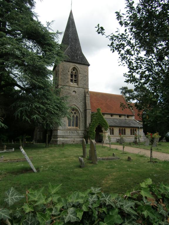
| Description | : | All Saints church, Brightwalton, Berkshire was constructed in 1861 on the site of a smaller Norman Church. The village of Brightwalton is located approximately 8-miles north of Newbury. |
frequently asked questions (FAQ):
-
Where is All Saints?
All Saints is located at Brightwalton, West Berkshire Unitary Authority ,Berkshire ,England.
-
All Saints cemetery's updated grave count on graveviews.com?
0 memorials
-
Where are the coordinates of the All Saints?
Latitude: 51.5109870
Longitude: -1.3860750
Nearby Cemetories:
1. St Andrew's Churchyard
Chaddleworth, West Berkshire Unitary Authority, England
Coordinate: 51.4969190, -1.4070694
2. All Saints Churchyard
Farnborough, West Berkshire Unitary Authority, England
Coordinate: 51.5346370, -1.3741600
3. Poughley Priory
Chaddleworth, West Berkshire Unitary Authority, England
Coordinate: 51.4770570, -1.4012960
4. St. Mary's Churchyard
Fawley, West Berkshire Unitary Authority, England
Coordinate: 51.5298010, -1.4375380
5. All Saints Churchyard
West Ilsley, West Berkshire Unitary Authority, England
Coordinate: 51.5393520, -1.3187210
6. Saint Thomas Churchyard
Little Shefford, West Berkshire Unitary Authority, England
Coordinate: 51.4697450, -1.4390310
7. St. Mary's Churchyard
Great Shefford, West Berkshire Unitary Authority, England
Coordinate: 51.4761000, -1.4541700
8. St Marys Churchyard
East Ilsley, West Berkshire Unitary Authority, England
Coordinate: 51.5249930, -1.2903250
9. Isley Baptist Churchyard
East Ilsley, West Berkshire Unitary Authority, England
Coordinate: 51.5270990, -1.2896650
10. St Michael & All Angels Churchyard
Letcombe Bassett, Vale of White Horse District, England
Coordinate: 51.5620598, -1.4620905
11. All Saints Churchyard
Wantage, Vale of White Horse District, England
Coordinate: 51.5827496, -1.3822236
12. East Lockinge War Memorial
Wantage, Vale of White Horse District, England
Coordinate: 51.5844426, -1.3883416
13. East Lockinge All Souls Church Cemetery
Lockinge, Vale of White Horse District, England
Coordinate: 51.5846900, -1.3899900
14. Chain Hill Cemetery
Wantage, Vale of White Horse District, England
Coordinate: 51.5843868, -1.4217107
15. St. Andrew Churchyard
Letcombe Regis, Vale of White Horse District, England
Coordinate: 51.5758900, -1.4527800
16. Holy Trinity Churchyard
Ardington, Vale of White Horse District, England
Coordinate: 51.5920530, -1.3784550
17. St. Peter and Paul Churchyard
Wantage, Vale of White Horse District, England
Coordinate: 51.5886860, -1.4284970
18. Wantage Baptist Church
Wantage, Vale of White Horse District, England
Coordinate: 51.5892190, -1.4270540
19. Holy Trinity Churchyard
West Hendred, Vale of White Horse District, England
Coordinate: 51.5916030, -1.3556760
20. Vicarage Hill Cemetery
East Challow, Vale of White Horse District, England
Coordinate: 51.5877810, -1.4512553
21. St Mary Roman Catholic Churchyard
East Hendred, Vale of White Horse District, England
Coordinate: 51.5937960, -1.3363240
22. St. Augustine of Canterbury Churchyard
East Hendred, Vale of White Horse District, England
Coordinate: 51.5944074, -1.3382489
23. Saint Mary and Saint Nicholas Churchyard
Compton, West Berkshire Unitary Authority, England
Coordinate: 51.5131760, -1.2430860
24. Cat Street Cemetery
East Hendred, Vale of White Horse District, England
Coordinate: 51.5964877, -1.3397450