
| Memorials | : | 151 |
| Location | : | Long Sutton, Hart District, England |
| Coordinate | : | 51.2207300, -0.9432800 |
| Description | : | Long Sutton is in an exclusive setting with easy access to the likes of Farnham, Fleet, Basingstoke, Reading and Alton. With a small village population there is a strong sense of community and the annual village summer fete is a key calendar event. The village is home to a family of ducks in the pond, a church and a recreation ground which is in regular use. The village includes picturesque brick and half-timbered cottages, and a farmhouse dating from Tudor times. In 1,200 acres (4.9 km2) of farmland stands Lord Wandsworth College, a Neo-Georgian structure built in 1915, founded as... Read More |
frequently asked questions (FAQ):
-
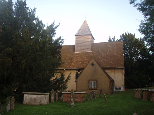
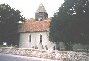
Where is All Saints Churchyard?
All Saints Churchyard is located at The Street Long Sutton, Hart District ,Hampshire , RG29 1STEngland.
-
All Saints Churchyard cemetery's updated grave count on graveviews.com?
151 memorials
-
Where are the coordinates of the All Saints Churchyard?
Latitude: 51.2207300
Longitude: -0.9432800
Nearby Cemetories:
1. Long Sutton Cemetery
Long Sutton, Hart District, England
Coordinate: 51.2193610, -0.9465190
2. St Andrew Churchyard
South Warnborough, Hart District, England
Coordinate: 51.2198000, -0.9684700
3. Froyle Cemetery
Froyle, East Hampshire District, England
Coordinate: 51.1941910, -0.9479140
4. Odiham Cemetery
Odiham, Hart District, England
Coordinate: 51.2521010, -0.9360700
5. All Saints Churchyard
Odiham, Hart District, England
Coordinate: 51.2529200, -0.9407000
6. St. Mary's Churchyard
Greywell, Hart District, England
Coordinate: 51.2536700, -0.9719700
7. St. Mary's Churchyard
Upton Grey, Basingstoke and Deane Borough, England
Coordinate: 51.2307800, -1.0025200
8. Assumption of the Blessed Virgin Mary Churchyard
Froyle, East Hampshire District, England
Coordinate: 51.1800930, -0.9203620
9. St Lawrence Churchyard
Weston Patrick, Basingstoke and Deane Borough, England
Coordinate: 51.2170740, -1.0121040
10. St. Mary's Churchyard
Bentley, East Hampshire District, England
Coordinate: 51.1957900, -0.8791600
11. All Saints Churchyard
Crondall, Hart District, England
Coordinate: 51.2299830, -0.8633050
12. St Stephen Churchyard
Up Nately, Basingstoke and Deane Borough, England
Coordinate: 51.2627500, -0.9971500
13. Holy Rood Churchyard
Holybourne, East Hampshire District, England
Coordinate: 51.1657120, -0.9535570
14. St Mary Churchyard
Mapledurwell, Basingstoke and Deane Borough, England
Coordinate: 51.2538100, -1.0161300
15. All Saints Churchyard
Tunworth, Basingstoke and Deane Borough, England
Coordinate: 51.2312600, -1.0367400
16. All Saints Churchyard
Dogmersfield, Hart District, England
Coordinate: 51.2674100, -0.8810800
17. St Mary the Virgin Churchyard
Winchfield, Hart District, England
Coordinate: 51.2764500, -0.9012600
18. St. Swithun Churchyard
Nately Scures, Basingstoke and Deane Borough, England
Coordinate: 51.2719600, -1.0022200
19. St John the Evangelist Churchyard
Hook, Hart District, England
Coordinate: 51.2833900, -0.9601300
20. Hook Cemetery
Hook, Hart District, England
Coordinate: 51.2840400, -0.9602700
21. Holy Cross Churchyard
Binsted, East Hampshire District, England
Coordinate: 51.1625300, -0.8981650
22. St Peter and St Paul Churchyard
Shalden, East Hampshire District, England
Coordinate: 51.1703300, -1.0097400
23. St Nicholas Churchyard
Newnham, Basingstoke and Deane Borough, England
Coordinate: 51.2806190, -0.9922190
24. St Mary Churchyard
Herriard, Basingstoke and Deane Borough, England
Coordinate: 51.2093000, -1.0515700