
| Memorials | : | 0 |
| Location | : | Nailsworth, Stroud District, England |
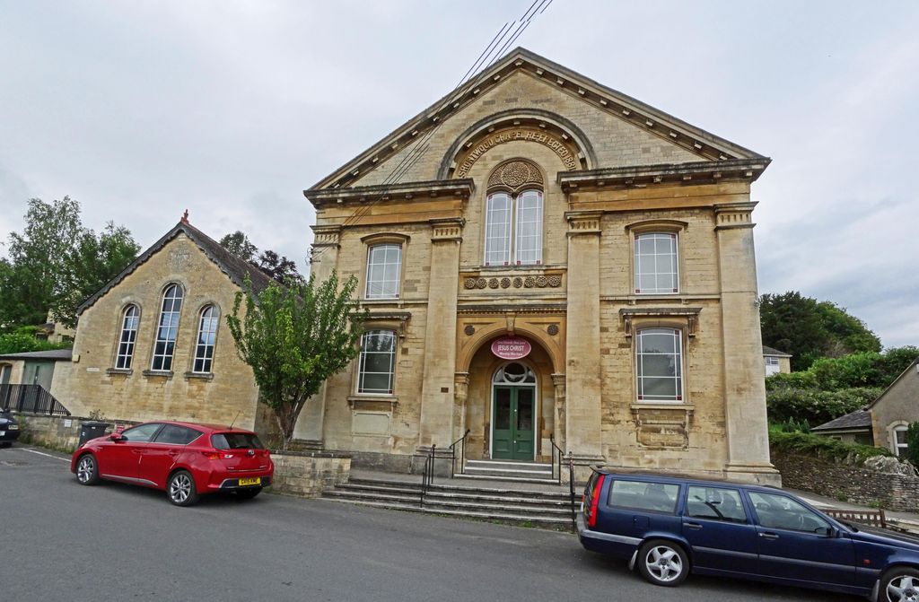
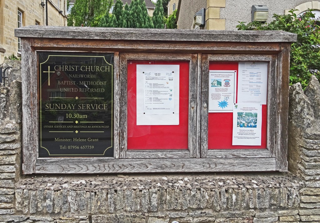
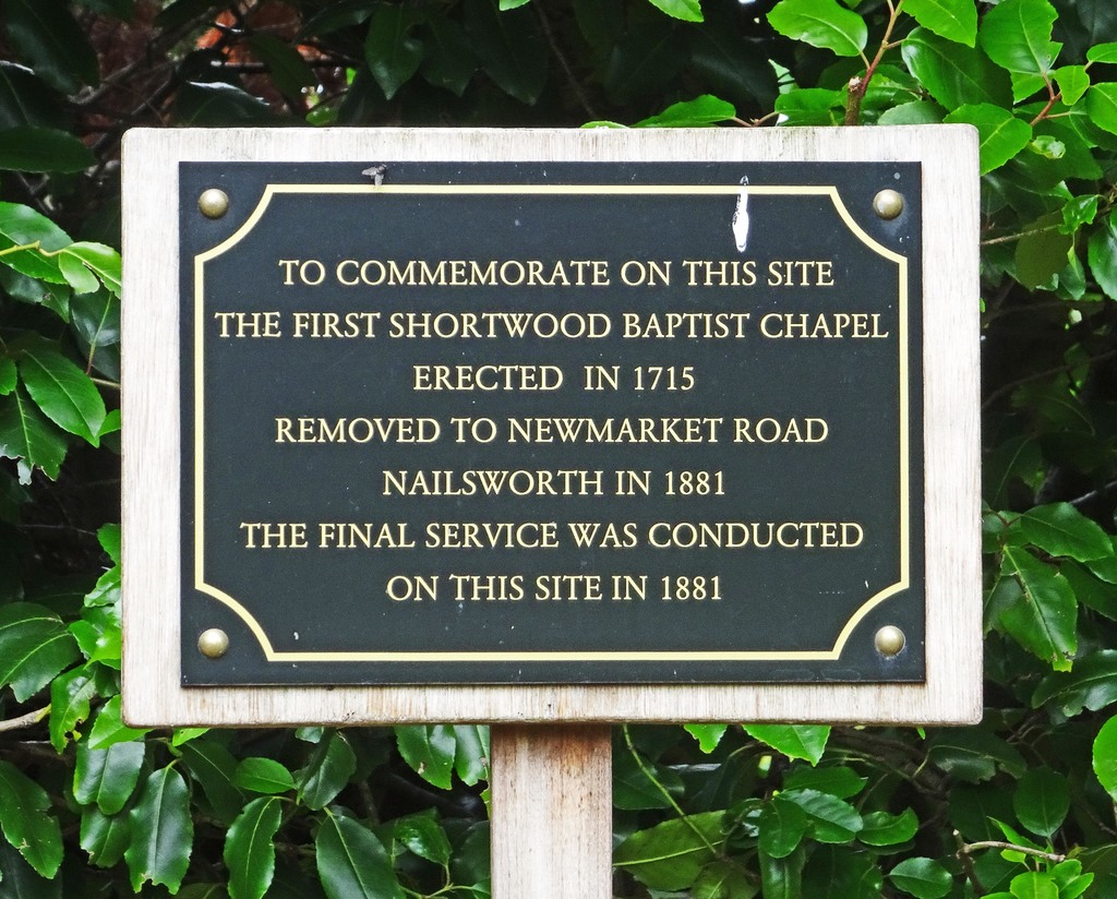
| Description | : | The Chapel that was originally located on this site has been demolished and a new chapel was built in 1881 at Newmarket Road, Nailsworth where it still stands. It is now called Christ Church and caters for Baptist, Methodist and United Reformed Denominations. |
frequently asked questions (FAQ):
-
Where is Baptist Chapelyard?
Baptist Chapelyard is located at Nailsworth, Stroud District, England.
-
Baptist Chapelyard cemetery's updated grave count on graveviews.com?
0 memorials
Nearby Cemetories:
1. St. Mary the Virgin Churchyard
Arlingham, Stroud District, England
2. Saint Matthews Churchyard
Cainscross, Stroud District, England
3. St. Michael and All Angels Churchyard
Eastington, Stroud District, England
Coordinate: 51.6155170, -2.3357530
4. Saint Andrew's Churchyard
Frocester, Stroud District, England
Coordinate: 51.7165900, -2.1900600
5. St Peters Churchyard
Frocester, Stroud District, England
6. Kings Stanley Baptist Cemetery
Kings Stanley, Stroud District, England
Coordinate: 51.6823727, -2.3571669
7. St George's Churchyard
Kings Stanley, Stroud District, England
Coordinate: 51.6893700, -2.3623400
8. Congregational Chapel Cemetery
Nailsworth, Stroud District, England
Coordinate: 51.6812840, -2.3530000
9. All Saints Churchyard, Shortwood
Nailsworth, Stroud District, England
Coordinate: 51.6777900, -2.3499800
10. Painswick Cemetery
Painswick, Stroud District, England
Coordinate: 51.7012900, -2.3653000
11. St. Mary the Virgin Churchyard
Painswick, Stroud District, England
Coordinate: 51.7804140, -2.3873960
12. St James the Great Churchyard
Saul, Stroud District, England
Coordinate: 51.6054787, -2.3318073
13. St Nicholas' Church
Standish, Stroud District, England
14. Upton St. Leonards Parish Church
Upton St Leonards, Stroud District, England
15. St Kenelm Churchyard
Alderley, Stroud District, England
Coordinate: 51.6155170, -2.3357530
16. Brimscombe Cemetery
Brimscombe, Stroud District, England
Coordinate: 51.7165900, -2.1900600
17. Holy Trinity Churchyard
Brimscombe, Stroud District, England
18. Dursley Tabernacle URC
Dursley, Stroud District, England
Coordinate: 51.6823727, -2.3571669
19. Dursley Town Cemetery
Dursley, Stroud District, England
Coordinate: 51.6893700, -2.3623400
20. St James the Great Church
Dursley, Stroud District, England
Coordinate: 51.6812840, -2.3530000
21. St Marks Churchyard
Dursley, Stroud District, England
Coordinate: 51.6777900, -2.3499800
22. St. Bartholomew's Churchyard
Dursley, Stroud District, England
Coordinate: 51.7012900, -2.3653000
23. St Mary the Virgin Churchyard
Fretherne, Stroud District, England
Coordinate: 51.7804140, -2.3873960
24. Hillesley Baptist Churchyard
Hillesley, Stroud District, England
Coordinate: 51.6054787, -2.3318073