
| Memorials | : | 1 |
| Location | : | Bourton-on-the-Water, Cotswold District, England |
| Website | : | churchdb.gukutils.org.uk/GLS774.php |
| Coordinate | : | 51.8856973, -1.7530678 |
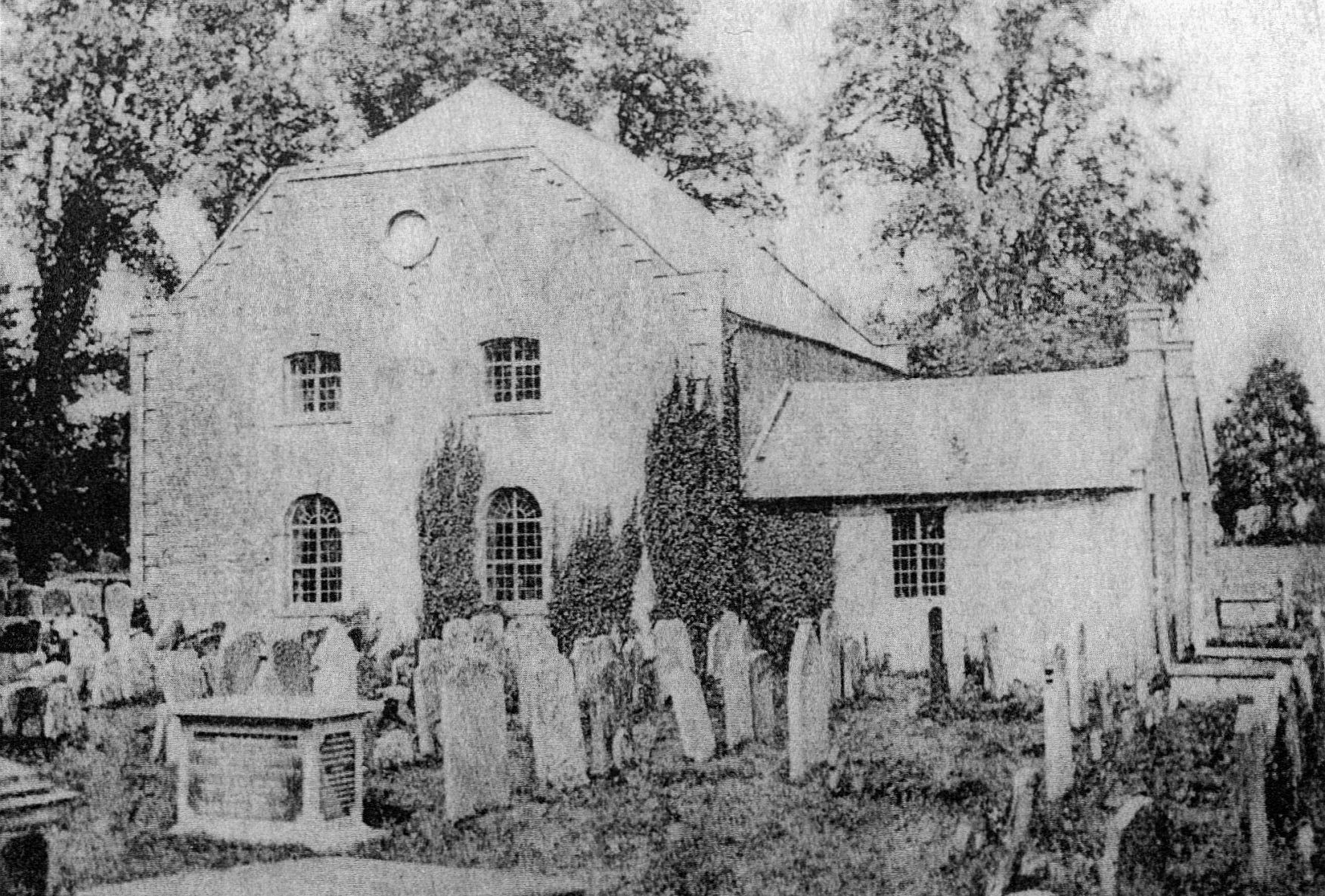
| Description | : | This Place of Worship was founded in 1655, but we understand it was closed in 1876. This former meeting house was replaced in 1876 by the building which is today's Bourton on the Water Baptist Church. It was built in 1701 for a congregation in existence by 1655, but has now been demolished. The surrounding burial ground survives, and is situated next to Bourton on the Water Cemetery. It is enclosed by a stone wall, and is approached through its own separate entrance. |
frequently asked questions (FAQ):
-
Where is Baptist Churchyard?
Baptist Churchyard is located at Cemetery Lane, Bourton-on-the-Water, Gloucestershire, England Bourton-on-the-Water, Cotswold District ,Gloucestershire ,England.
-
Baptist Churchyard cemetery's updated grave count on graveviews.com?
1 memorials
-
Where are the coordinates of the Baptist Churchyard?
Latitude: 51.8856973
Longitude: -1.7530678
Nearby Cemetories:
1. Water Cemetery
Bourton-on-the-Water, Cotswold District, England
Coordinate: 51.8853540, -1.7530440
2. St Lawrence Churchyard
Bourton-on-the-Water, Cotswold District, England
Coordinate: 51.8860500, -1.7588250
3. St. Mary's Churchyard
Lower Slaughter, Cotswold District, England
Coordinate: 51.9018830, -1.7605380
4. St. Peter's Churchyard
Little Rissington, Cotswold District, England
Coordinate: 51.8780460, -1.7262610
5. The Parish Church of St. Peter
Upper Slaughter, Cotswold District, England
Coordinate: 51.9074150, -1.7764140
6. St. John the Baptist Churchyard
Great Rissington, Cotswold District, England
Coordinate: 51.8526130, -1.7180490
7. St. Mary the Virgin Churchyard
Icomb, Cotswold District, England
Coordinate: 51.9018000, -1.6905000
8. Stow-on-the-Wold Cemetery
Stow-on-the-Wold, Cotswold District, England
Coordinate: 51.9264100, -1.7254670
9. St. Edward Churchyard
Stow-on-the-Wold, Cotswold District, England
Coordinate: 51.9299810, -1.7238290
10. St Mary's Churchyard
Upper Swell, Cotswold District, England
Coordinate: 51.9398030, -1.7441910
11. Sherborne Churchyard extension
Sherborne, Cotswold District, England
Coordinate: 51.8308450, -1.7536600
12. St Mary Magdalene Churchyard
Sherborne, Cotswold District, England
Coordinate: 51.8308380, -1.7562570
13. St Bartholomew Churchyard
Notgrove, Cotswold District, England
Coordinate: 51.8778620, -1.8426720
14. Naunton Baptist Chapel
Naunton, Cotswold District, England
Coordinate: 51.9092073, -1.8356252
15. St Andrew's Churchyard
Naunton, Cotswold District, England
Coordinate: 51.9091340, -1.8384210
16. St Nicholas Churchyard
Idbury, West Oxfordshire District, England
Coordinate: 51.8784370, -1.6584080
17. Saint John the Baptist Church
Fifield, West Oxfordshire District, England
Coordinate: 51.8668460, -1.6536260
18. All Saints Churchyard
Turkdean, Cotswold District, England
Coordinate: 51.8554710, -1.8456120
19. St Paul Churchyard
Broadwell, Cotswold District, England
Coordinate: 51.9476200, -1.7095100
20. St Nicholas Churchyard
Oddington, Cotswold District, England
Coordinate: 51.9278340, -1.6597080
21. SS Peter & Paul
Northleach, Cotswold District, England
Coordinate: 51.8295720, -1.8390300
22. St Peter Churchyard
Daylesford, Cotswold District, England
Coordinate: 51.9310080, -1.6479680
23. St. Peter's Churchyard
Little Barrington, Cotswold District, England
Coordinate: 51.8130930, -1.6983770
24. St. James Churchyard
Longborough, Cotswold District, England
Coordinate: 51.9658220, -1.7407990