
| Memorials | : | 0 |
| Location | : | Butley, Suffolk Coastal District, England |
| Coordinate | : | 52.0910000, 1.4650000 |
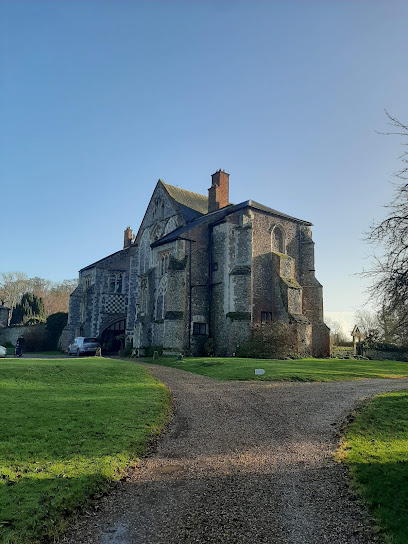
| Description | : | Butley Priory, sometimes called Butley Abbey, was a religious house of Canons regular (Augustinians, Black canons) in Butley, Suffolk, dedicated to The Blessed Virgin Mary. It was founded in 1171 by Ranulf de Glanville (c. 1112-1190), Chief Justiciar to King Henry II (1180-1189), and was the sister foundation to Ranulf's house of White canons (Premonstratensians) at Leiston Abbey, a few miles to the north, founded c. 1183. Butley Priory was suppressed in 1538. Although only minor fragments of the priory church and some masonry of the convent survive at Abbey Farm, the underground archaeology was expertly investigated and interpreted in 1931-33,... Read More |
frequently asked questions (FAQ):
-
Where is Butley Priory?
Butley Priory is located at Butley, Suffolk Coastal District ,Suffolk ,England.
-
Butley Priory cemetery's updated grave count on graveviews.com?
0 memorials
-
Where are the coordinates of the Butley Priory?
Latitude: 52.0910000
Longitude: 1.4650000
Nearby Cemetories:
1. St John the Baptist Churchyard
Butley, Suffolk Coastal District, England
Coordinate: 52.0989210, 1.4647100
2. St. Andrew's Churchyard
Boyton, Suffolk Coastal District, England
Coordinate: 52.0711930, 1.4609030
3. St. Peter's Churchyard
Chillesford, Suffolk Coastal District, England
Coordinate: 52.1169420, 1.4787340
4. St Bartholomew's Churchyard
Orford, Suffolk Coastal District, England
Coordinate: 52.0952340, 1.5352670
5. All Saints Churchyard
Sudbourne, Suffolk Coastal District, England
Coordinate: 52.1127220, 1.5343890
6. All Saints Churchyard
Hollesley, Suffolk Coastal District, England
Coordinate: 52.0473600, 1.4304300
7. Tunstall Baptist Chapel Yard
Tunstall, Suffolk Coastal District, England
Coordinate: 52.1437000, 1.4529690
8. Saint Michael's Churchyard
Tunstall, Suffolk Coastal District, England
Coordinate: 52.1437250, 1.4524320
9. St Gregory the Great Churchyard
Rendlesham, Suffolk Coastal District, England
Coordinate: 52.1247080, 1.3952270
10. All Saints Church Burial Ground
Eyke, Suffolk Coastal District, England
Coordinate: 52.1156810, 1.3832240
11. St. Margaret's Churchyard
Shottisham, Suffolk Coastal District, England
Coordinate: 52.0520710, 1.3841940
12. St Edmund's Churchyard
Bromeswell, Suffolk Coastal District, England
Coordinate: 52.1064300, 1.3617740
13. All Saints Churchyard
Sutton, Suffolk Coastal District, England
Coordinate: 52.0682690, 1.3636990
14. Campsey Priory
Campsey Ash, Suffolk Coastal District, England
Coordinate: 52.1396150, 1.3866000
15. St Peter's Churchyard
Blaxhall, Suffolk Coastal District, England
Coordinate: 52.1604450, 1.4442330
16. St John the Baptist Churchyard
Campsey Ash, Suffolk Coastal District, England
Coordinate: 52.1520000, 1.4040000
17. Melton Old Churchyard
Melton, Suffolk Coastal District, England
Coordinate: 52.1125150, 1.3505240
18. St. Botolph's Churchyard
Iken, Suffolk Coastal District, England
Coordinate: 52.1550820, 1.5250830
19. St. Andrew's Churchyard
Alderton, Suffolk Coastal District, England
Coordinate: 52.0239900, 1.4136300
20. St Andrew the Apostle Churchyard
Melton, Suffolk Coastal District, England
Coordinate: 52.1065910, 1.3336210
21. St. Peter and St. Paul Churchyard
Pettistree, Suffolk Coastal District, England
Coordinate: 52.1410880, 1.3525270
22. St Audry's Hospital Chapel Burial Grounds
Melton, Suffolk Coastal District, England
Coordinate: 52.1169050, 1.3321920
23. St. Mary's Churchyard
Bawdsey, Suffolk Coastal District, England
Coordinate: 52.0098980, 1.4177850
24. All Saints Churchyard
Ramsholt, Suffolk Coastal District, England
Coordinate: 52.0294500, 1.3617700