
| Memorials | : | 0 |
| Location | : | Ruby, Chesterfield County, USA |
| Coordinate | : | 34.7502340, -80.1913550 |
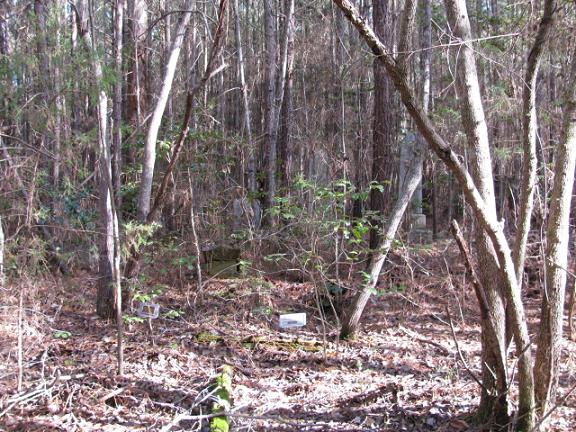
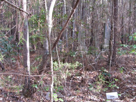
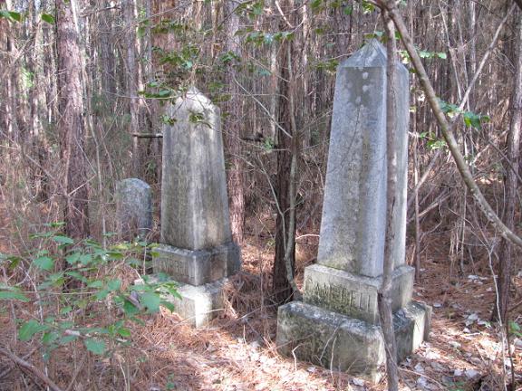
| Description | : | Note: This cemetery has been called Hancock Cemetery but the local people call it the Campbell Cemetery. Take Highway 9 West from the intersection at Ruby Baptist Church. Go just past the Ruby-Mount Croghan Fire Department. There will be a dirt drive to the right beside a field. In January of 2009 there is a small camper trailer about 100 yards off Highway 9 on this dirt drive. Turn down this dirt drive and start down the hill. The cemetery will be about half way down the hill to the right about 100 yards. If you look closely there is a plastic... Read More |
frequently asked questions (FAQ):
-
Where is Campbell Cemetery?
Campbell Cemetery is located at Highway 9 West Ruby, Chesterfield County ,South Carolina ,USA.
-
Campbell Cemetery cemetery's updated grave count on graveviews.com?
0 memorials
-
Where are the coordinates of the Campbell Cemetery?
Latitude: 34.7502340
Longitude: -80.1913550
Nearby Cemetories:
1. Brantley Family Cemetery
Ruby, Chesterfield County, USA
Coordinate: 34.7468360, -80.1879220
2. Smith Family Cemetery
Ruby, Chesterfield County, USA
Coordinate: 34.7451960, -80.1958290
3. Hancock Cemetery
Ruby, Chesterfield County, USA
Coordinate: 34.7579830, -80.1923260
4. Smith Cemetery
Ruby, Chesterfield County, USA
Coordinate: 34.7449670, -80.2004310
5. Smith Cemetery
Ruby, Chesterfield County, USA
Coordinate: 34.7451040, -80.1773000
6. Sellers Cemetery
Ruby, Chesterfield County, USA
Coordinate: 34.7590400, -80.2025340
7. Ruby Cemetery
Ruby, Chesterfield County, USA
Coordinate: 34.7447014, -80.1769028
8. Rock Springs Baptist Church Cemetery
Ruby, Chesterfield County, USA
Coordinate: 34.7338650, -80.1962580
9. Gulledge Family Cemetery
Ruby, Chesterfield County, USA
Coordinate: 34.7685860, -80.1802830
10. Ruby Church of God Cemetery
Ruby, Chesterfield County, USA
Coordinate: 34.7406250, -80.2151300
11. Melton Family Cemetery
Ruby, Chesterfield County, USA
Coordinate: 34.7428650, -80.1607650
12. Gulledge Cemetery
Ruby, Chesterfield County, USA
Coordinate: 34.7370540, -80.2192710
13. Gulledge Cemetery
Mount Croghan, Chesterfield County, USA
Coordinate: 34.7516890, -80.2247430
14. Timmonsville Baptist Church Cemetery Old
Mount Croghan, Chesterfield County, USA
Coordinate: 34.7789940, -80.1903360
15. Gaddy-Sellers Cemetery
Ruby, Chesterfield County, USA
Coordinate: 34.7500840, -80.1534820
16. Sellers Family Cemetery
Chesterfield, Chesterfield County, USA
Coordinate: 34.7437060, -80.1537960
17. Massey Cemetery
Ruby, Chesterfield County, USA
Coordinate: 34.7783050, -80.1735600
18. Timmonsville Baptist Church Cemetery
Mount Croghan, Chesterfield County, USA
Coordinate: 34.7825050, -80.1944070
19. Mount Croghan United Methodist Church Cemetery
Mount Croghan, Chesterfield County, USA
Coordinate: 34.7686430, -80.2240780
20. Mount Croghan Memorial Park
Mount Croghan, Chesterfield County, USA
Coordinate: 34.7686005, -80.2244034
21. Elizabeth Baptist Church Cemetery
Mount Croghan, Chesterfield County, USA
Coordinate: 34.7806015, -80.2130966
22. Thompson Creek Baptist Church Cemetery New
Chesterfield County, USA
Coordinate: 34.7756004, -80.1575012
23. Mount Airy A.M.E. Zion Church Cemetery
Chesterfield, Chesterfield County, USA
Coordinate: 34.7315780, -80.1514510
24. Berkley Family Cemetery
Chesterfield, Chesterfield County, USA
Coordinate: 34.7376230, -80.1478220