
| Memorials | : | 0 |
| Location | : | Charlwood, Mole Valley District, England |
| Coordinate | : | 51.1553700, -0.2305800 |
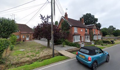
| Description | : | The small low build is part of an open hall house, including a main truss and a square stair turret, but the other part has been replaced by the brick build, probably in the late 1700's. We know something of its history from documents, which confirm that it was a tanyard. The property was left to the Society of Friends (Quakers) who had used it for small meetings and who also used a nearby field as a Quaker burial ground, the earliest in the area. At least 111 Quakers were buried here. (Surrey/Sussex registers at Friends House). There is a... Read More |
frequently asked questions (FAQ):
-
Where is Charlwood Friends Burial Ground?
Charlwood Friends Burial Ground is located at Russ Hill Road Charlwood, Mole Valley District ,Surrey , RH6 0EJEngland.
-
Charlwood Friends Burial Ground cemetery's updated grave count on graveviews.com?
0 memorials
-
Where are the coordinates of the Charlwood Friends Burial Ground?
Latitude: 51.1553700
Longitude: -0.2305800
Nearby Cemetories:
1. Friends Meeting House
Ifield, Crawley Borough, England
Coordinate: 51.1263400, -0.2120200
2. St Margaret of Antioch Churchyard
Ifield, Crawley Borough, England
Coordinate: 51.1238700, -0.2194760
3. St. Bartholomew's Churchyard
Horley, Reigate and Banstead Borough, England
Coordinate: 51.1698000, -0.1758000
4. St Peter Churchyard
Newdigate, Mole Valley District, England
Coordinate: 51.1652200, -0.2884860
5. Parish of Horley's New Churchyard
Horley, Reigate and Banstead Borough, England
Coordinate: 51.1711120, -0.1747610
6. Snell Hatch Cemetery
Crawley, Crawley Borough, England
Coordinate: 51.1164130, -0.2053970
7. Saint Mary Magdalene Churchyard
Rusper, Horsham District, England
Coordinate: 51.1227750, -0.2789080
8. St John the Baptist Church
Crawley, Crawley Borough, England
Coordinate: 51.1140840, -0.1892240
9. Friary Churchyard of St. Francis and St. Anthony
Crawley, Crawley Borough, England
Coordinate: 51.1133670, -0.1875970
10. St. Bartholomew's Churchyard
Leigh, Mole Valley District, England
Coordinate: 51.2085790, -0.2483520
11. Pleystowe in Capel Friends Grounds
Capel, Mole Valley District, England
Coordinate: 51.1411900, -0.3161300
12. Sidlow Bridge Emmanuel Churchyard
Sidlow, Reigate and Banstead Borough, England
Coordinate: 51.2077270, -0.1989510
13. Surrey and Sussex Crematorium
Crawley, Crawley Borough, England
Coordinate: 51.1357000, -0.1469230
14. St. John the Baptist Churchyard
Capel, Mole Valley District, England
Coordinate: 51.1539730, -0.3201980
15. Capel Friends Burial Ground #2
Capel, Mole Valley District, England
Coordinate: 51.1513970, -0.3219210
16. St Bartholomew Churchyard
Burstow, Tandridge District, England
Coordinate: 51.1558610, -0.1247750
17. St Mary Magdalene Churchyard
South Holmwood, Mole Valley District, England
Coordinate: 51.1904660, -0.3243540
18. St Nicholas Churchyard
Worth, Mid Sussex District, England
Coordinate: 51.1102870, -0.1415280
19. St John the Evangelist Churchyard
Copthorne, Crawley Borough, England
Coordinate: 51.1394100, -0.1175700
20. St Margaret Churchyard
Ockley, Mole Valley District, England
Coordinate: 51.1534880, -0.3473790
21. St Saviour Churchyard
Colgate, Horsham District, England
Coordinate: 51.0817080, -0.2444000
22. Smallfield Ebenezer Chapel Cemetery
Smallfield, Tandridge District, England
Coordinate: 51.1770230, -0.1151960
23. St. Michael's Churchyard
Betchworth, Mole Valley District, England
Coordinate: 51.2336480, -0.2673300
24. Reigate Cemetery
Reigate, Reigate and Banstead Borough, England
Coordinate: 51.2353550, -0.1977820